- Australia ▾
- Topographic
▾
- Australia AUSTopo 250k (2024)
- Australia 50k Geoscience maps
- Australia 100k Geoscience maps
- Australia 250k Geoscience maps
- Australia 1.1m Geoscience maps
- New Zealand 50k maps
- New Zealand 250k maps
- New South Wales 25k maps
- New South Wales 50k maps
- New South Wales 100k maps
- Queensland 10k maps
- Queensland 25k maps
- Queensland 50k maps
- Queensland 100k maps
- Compasses
- Software
- GPS Systems
- Orienteering
- International ▾
- Wall Maps
▾
- World
- Australia & New Zealand
- Countries, Continents & Regions
- Historical
- Vintage National Geographic
- Australian Capital Territory
- New South Wales
- Northern Territory
- Queensland
- South Australia
- Tasmania
- Victoria
- Western Australia
- Celestial
- Children's
- Mining & Resources
- Wine Maps
- Healthcare
- Postcode Maps
- Electoral Maps
- Nautical ▾
- Flags
▾
- Australian Flag Sets & Banners
- Flag Bunting
- Handwavers
- Australian National Flags
- Aboriginal Flags
- Torres Strait Islander Flags
- International Flags
- Flagpoles & Accessories
- Australian Capital Territory Flags
- New South Wales Flags
- Northern Territory Flags
- Queensland Flags
- South Australia Flags
- Tasmania Flags
- Victoria Flags
- Western Australia Flags
- Gifts ▾
- Globes ▾
Dear valued customer. Please note that our checkout is not supported by old browsers. Please use a recent browser to access all checkout capabilities


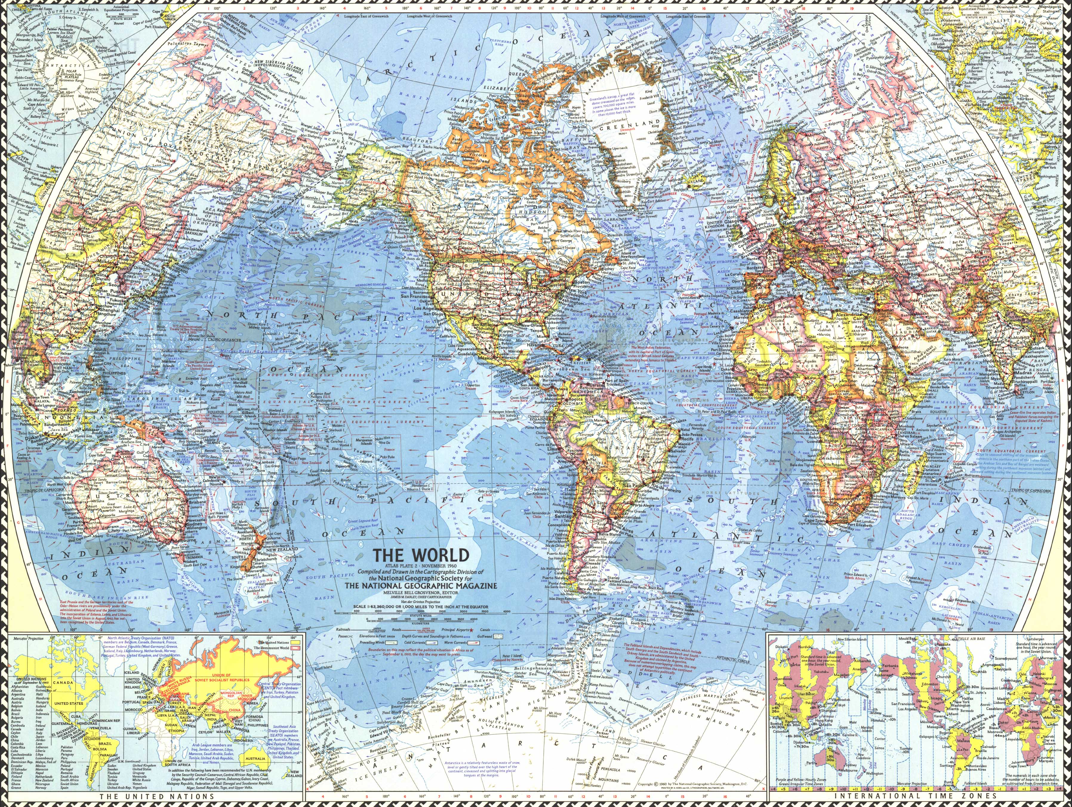
World Wall Map 1960 by National Geographic
$69.95
or make 4 interest-free payments of
$17.49 AUD
fortnightly with
![]() More info
More info
Borders, Currents & Independence — World Wall Map (1960)
A snapshot of a world in transition, rendered with clarity and restraint. Published by National Geographic in 1960, this world sheet captures the sweeping post-colonial changes in Africa as of September 1960. Vivid country borders, thousands of place names (including capitals), and rich oceanography—depth curves and soundings (in fathoms), warm/cold currents, and prevailing winds—are set out in clean, legible cartography that rewards both room-distance viewing and close study. North and South Polar insets, international time zones, and a United Nations / Communist World inset round out a compelling, era-true reference.
More Than a Map – A Testament to History
This isn’t just wall art—it’s a record of decolonisation and global connectivity at a pivotal moment. Trace newly independent African states, compare UN membership against geopolitical blocs, and read the world’s networks via principal airports, canals, and transport corridors layered over terrain and sea. Ideal for educators, planners, historians, designers, and collectors, this sheet pairs beautifully with earlier and later National Geographic world maps for a powerful then-and-now display.
Hang it in studios, libraries, classrooms, museums, offices, or at home to invite reflection, study, and conversation.
Premium Materials & Finishes
We treat history with the respect it deserves. That’s why we offer multiple formats, each produced using high-quality materials and modern archival printing.
🌟 Archival Paper Print
Printed on heavyweight 160gsm archival-grade paper.
Smooth matte finish reduces glare and preserves fine linework and small labels.
Ideal for framing under glass—clean, timeless, and built to last.
💎 Laminated Edition
Encapsulated in two sheets of 80-micron gloss laminate using true thermal bonding—not just surface lamination.
Moisture-resistant, wipe-clean surface—perfect for classrooms and high-traffic reference spaces.
Optional Natural Timber Hang Rails: lacquered rails with a fitted hanging cord provide a polished, ready-to-hang presentation—no frame required. (Please allow up to 10 working days for delivery with hang rails.)
🏆 Museum-Quality Canvas
Printed on heavyweight 395gsm HP Professional Matte Canvas for rich texture and exceptional strength.
Pigment-based, fade-resistant inks deliver deep tone and crisp typography that endure for generations.
Optional Natural Timber Hang Rails: lacquered to enhance the wood grain and protect against wear; top cord for effortless hanging—elegant in any setting. (Please allow up to 10 working days for delivery with hang rails.)
Specifications
| Feature | Details |
|---|---|
| Title | World Wall Map |
| Series | National Geographic single-sheet world map |
| Original Publication | 1960 (showing updates as of September press date) |
| Scale | Not specified |
| Cartographic Content | Vivid borders; thousands of place names incl. capitals; North & South Polar insets; UN & Communist World inset; international time zones; principal airports; canals; depth curves & soundings (fathoms); elevations; prevailing winds; warm & cold ocean currents |
| Map Size | 632 mm (W) × 478 mm (H) |
| Available Formats | Paper, Laminated, Canvas |
| Paper Weight | 160gsm archival-quality |
| Laminate | 2 × 80-micron gloss laminate sheets (encapsulated) |
| Canvas Weight | 395gsm HP Professional Matte Canvas |
| Inks | Pigment-based, fade-resistant |
| Optional Hang Rails | Available on Laminated & Canvas (lead time up to 10 working days) |
| Origin | Made in Australia |
Why Choose This Map
✔ Era-True Snapshot: African independence and global borders exactly as mapped in 1960.
✔ Layered Context: UN / bloc inset, time zones, and polar panels at a glance.
✔ Network Insight: Airports, canals, and currents connect political and physical geography.
✔ Clarity at Scale: Classic National Geographic design with dense, readable detail.
✔ Archival Craft: Premium substrates and inks preserve contrast, labels, and linework for decades.
Our Commitment
We believe that preserving history is as important as telling it. Every map is printed locally in Australia using state-of-the-art technology, carefully checked by hand, and packed with care. From the moment it leaves our workshop to the day it hangs on your wall, we ensure quality you can trust and a legacy you’ll be proud to share.
Bring the turning point of 1960 into focus. Order the World Wall Map (1960) today—a faithful, beautifully produced sheet that turns a room into a conversation.


