- Australia ▾
- Topographic
▾
- Australia AUSTopo 250k (2025)
- Australia 50k Geoscience maps
- Australia 100k Geoscience maps
- Australia 250k Geoscience maps
- Australia 1:1m Geoscience maps
- New Zealand 50k maps
- New Zealand 250k maps
- New South Wales 25k maps
- New South Wales 50k maps
- New South Wales 100k maps
- Queensland 10k maps
- Queensland 25k maps
- Queensland 50k maps
- Queensland 100k maps
- Western Australia 25k maps
- Western Australia 50k maps
- Western Australia 100k maps
- Compasses
- Software
- GPS Systems
- International ▾
- Wall Maps
▾
- World
- Australia & New Zealand
- Countries, Continents & Regions
- Historical
- Vintage National Geographic
- Australian Capital Territory
- New South Wales
- Northern Territory
- Queensland
- South Australia
- Tasmania
- Victoria
- Western Australia
- Celestial
- Children's
- Mining & Resources
- Wine Maps
- Healthcare
- Postcode Maps
- Electoral Maps
- Nautical ▾
- Flags
▾
- Australian Flag Sets & Banners
- Flag Bunting
- Handwavers
- Australian National Flags
- Aboriginal Flags
- Torres Strait Islander Flags
- International Flags
- Flagpoles & Accessories
- Australian Capital Territory Flags
- New South Wales Flags
- Northern Territory Flags
- Queensland Flags
- South Australia Flags
- Tasmania Flags
- Victoria Flags
- Western Australia Flags
- Gifts ▾
- Globes ▾
Dear valued customer. Please note that our checkout is not supported by old browsers. Please use a recent browser to access all checkout capabilities


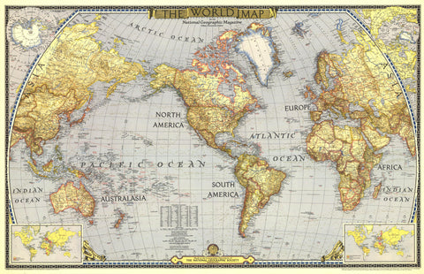
World Wall Map 1932 by National Geographic
$69.95
or make 4 interest-free payments of
$17.49 AUD
fortnightly with
![]() More info
More info
"The Story of the Map" – A Landmark in Cartographic History
Size: 970 x 656 mm
Originally Published: December 1932, National Geographic Magazine
Projection: Van der Grinten
Reproduction Format Options: Paper, Laminated, Canvas, or Canvas with Wooden Hang Rails
🗺️ A Timeless Map from the Golden Age of Exploration
Step back into the elegant world of early 20th-century exploration with this exquisite reproduction of the 1932 World Map by National Geographic – a masterpiece originally created to accompany the magazine's landmark article, “The Story of the Map.”
Crafted at a time when international borders were shifting and the world was still being charted in remote corners, this map offers a captivating historical window into the global imagination of the interwar years. Every detail – from its refined typography to the understated, sepia-toned palette – reflects the artistry, precision, and prestige of National Geographic’s celebrated cartographic legacy.
🔍 Map Features at a Glance
| 🧭 Feature | ✅ Description |
|---|---|
| Projection | Van der Grinten – Circular, classic world view |
| Borders | International borders, provinces, states, and territories |
| Cities & Capitals | Thousands of political and cultural centres identified |
| Polar Insets | North and South Polar Regions in dedicated panels |
| World Vegetation & Ocean Currents | Inset map showing global flora and marine circulation patterns |
| Population Density & Wind Currents | Demographic and atmospheric overlays, rare for maps of this period |
| Language | English |
| Design | Richly coloured in antique tones, with fine detailing and vintage styling |
📐 Specifications & Format Options
| Format | Material | Features |
|---|---|---|
| Paper (160gsm) | Heavyweight matte paper | Crisp, archival-quality print; perfect for framing under glass |
| Laminated | 80-micron gloss encapsulation | Wipe-clean surface; extra durability for frequent handling |
| Canvas (395gsm) | HP Matte Canvas + pigment ink | Fade-resistant, richly textured, museum-grade finish |
| Hang Rails | Timber rails | Ready-to-hang, with top/bottom rails and natural timber finish |
📦 Please allow up to 10 business days for hang-rail maps, which are handcrafted to order by our professional framer.
🎯 Who Is This Map For?
-
Historians & Educators – A compelling snapshot of pre-WWII geopolitics
-
Map Collectors & Enthusiasts – An iconic piece from the golden era of National Geographic
-
Interior Designers – A stunning centrepiece for offices, libraries, studies, or reading rooms
-
Gift Seekers – A thoughtful and distinctive present for lovers of history, geography, or travel
-
World Travellers & Dreamers – A source of inspiration, curiosity, and perspective
✨ Why Choose the 1932 National Geographic World Map?
-
🧭 Authenticity – Faithfully reproduced from the original 1932 publication
-
📚 Educational Value – Observe shifting borders, vanished nations, and early geopolitical dynamics
-
🎨 Aesthetic Appeal – Elegant vintage colouring, perfect for traditional or academic settings
-
🌊 Thematic Richness – Unique overlays such as wind currents and vegetation not commonly found in maps of this era
-
🖼️ Display-Ready Options – Whether framed, laminated, or canvas-mounted, this map is ready to enhance your space
🧵 Framing & Hanging Details
For maps with optional wooden hang rails, we include:
-
Natural timber finish (lacquered)
-
Hanging cord attached to the top roller
-
Lightweight and simple to mount – ideal for renters, educators, and collectors
📜 A Piece of Living History
This map is more than a reference tool – it’s a celebration of the curiosity and wonder that defined the early decades of global exploration. With insets illustrating the Earth’s ecosystems, ocean currents, wind systems, and population densities, it is both a work of art and a historical document.
Display it proudly. Gift it with meaning. Study it deeply.
➡️ Available in four premium formats.
📦 Ships worldwide.
🕰️ Maps with hang rails made to order – please allow 10 working days for delivery.
Frequently Asked Questions
What are the dimensions of the World Wall Map 1932 by National Geographic?
Mapworld wall maps range from standard 700×1000mm to large-format 1000×1430mm Supermaps. The exact dimensions for this map are shown in the product title. Where multiple sizes are available, select your preferred size when adding to cart.
Is this wall map available laminated?
Many Mapworld wall maps are available in paper, laminated, or framed finishes. Check the product options when adding to cart. Laminated maps are wipe-clean and more durable.
Is this the latest edition?
Mapworld stocks the most current editions available from all publishers. Edition year is shown in the product title where applicable. Mapworld updates its catalogue as new editions are released.
Can I write on or pin this wall map?
Laminated wall maps can be written on with whiteboard markers and wiped clean. Paper maps can be pinned on a corkboard. Choose a laminated option for a writeable surface.
Does Mapworld ship the World Wall Map 1932 by National Geographic across Australia?
Yes, Mapworld ships Australia-wide. Standard shipping is a flat $7 rate, with free standard shipping on orders over $75. Express options are available at checkout. Most orders placed before 2pm AEST on weekdays are dispatched same day.
Related Items


© 2026 Mapworld. Website designed by Genie Media
X