- Australia ▾
- Topographic
▾
- Australia AUSTopo 250k (2025)
- Australia 50k Geoscience maps
- Australia 100k Geoscience maps
- Australia 250k Geoscience maps
- Australia 1:1m Geoscience maps
- New Zealand 50k maps
- New Zealand 250k maps
- New South Wales 25k maps
- New South Wales 50k maps
- New South Wales 100k maps
- Queensland 10k maps
- Queensland 25k maps
- Queensland 50k maps
- Queensland 100k maps
- Western Australia 25k maps
- Western Australia 50k maps
- Western Australia 100k maps
- Compasses
- Software
- GPS Systems
- International ▾
- Wall Maps
▾
- World
- Australia & New Zealand
- Countries, Continents & Regions
- Historical
- Vintage National Geographic
- Australian Capital Territory
- New South Wales
- Northern Territory
- Queensland
- South Australia
- Tasmania
- Victoria
- Western Australia
- Celestial
- Children's
- Mining & Resources
- Wine Maps
- Healthcare
- Postcode Maps
- Electoral Maps
- Nautical ▾
- Flags
▾
- Australian Flag Sets & Banners
- Flag Bunting
- Handwavers
- Australian National Flags
- Aboriginal Flags
- Torres Strait Islander Flags
- International Flags
- Flagpoles & Accessories
- Australian Capital Territory Flags
- New South Wales Flags
- Northern Territory Flags
- Queensland Flags
- South Australia Flags
- Tasmania Flags
- Victoria Flags
- Western Australia Flags
- Gifts ▾
- Globes ▾
Dear valued customer. Please note that our checkout is not supported by old browsers. Please use a recent browser to access all checkout capabilities


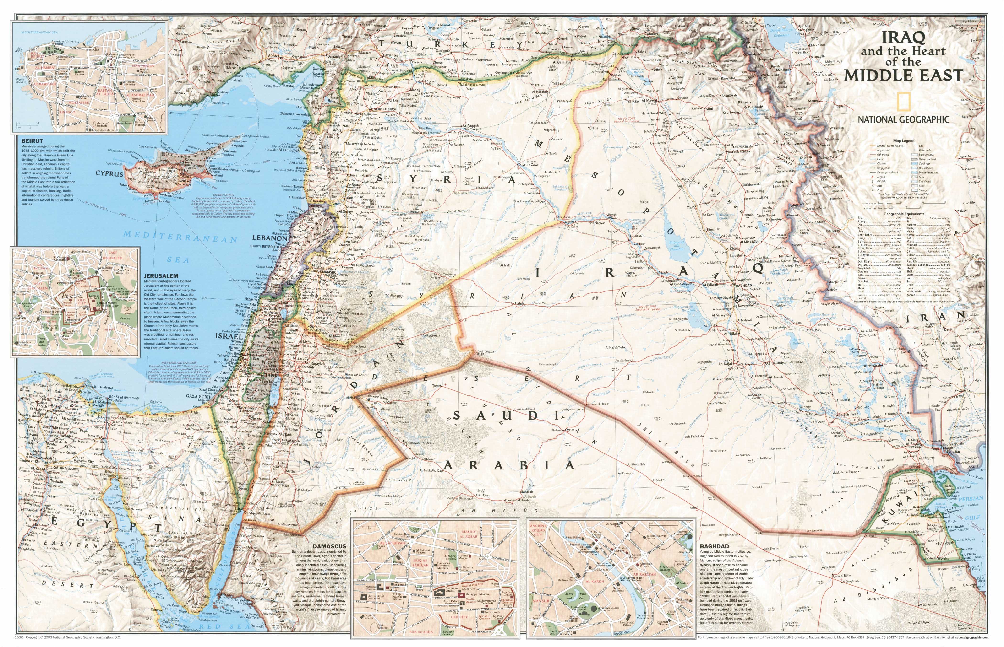
Iraq and the Heart of the Middle East Wall Map - Published 2003 by National Geographic
$69.95
or make 4 interest-free payments of
$17.49 AUD
fortnightly with
![]() More info
More info
Scale 1:1,983,000 | Published 2003 | Political, Cultural & Resource Detail
The Iraq and the Heart of the Middle East Wall Map, published in 2003 by National Geographic, is a remarkable combination of political geography, cultural insight, and resource mapping. Released during a pivotal year in Iraq’s modern history, it serves as both a reference tool and a snapshot of a moment in time — making it a valuable addition for educators, historians, collectors, and anyone with an interest in the region.
🗺️ A Map of Strategic and Cultural Importance
The main map presents an accurate and highly detailed political representation of Iraq and the broader Middle East, showing:
-
Clear country boundaries and names
-
Capital and major cities
-
Roads and transport infrastructure
-
Major bodies of water
-
Mountain ranges and desert areas
-
Oil fields, pipelines, and other key natural resources
To enrich the geographic information, the map features enlarged inset maps of Baghdad, Beirut, Damascus, and Jerusalem. Each inset includes a street-level plan and accompanying text describing the history, culture, and significance of these cities — making this map not just a navigational aid, but also a cultural and historical guide.
📜 Collector’s Note – Why the 2003 Edition Matters
The year 2003 marked a major turning point in Iraq’s history, with events that had global political and economic implications. This map reflects the geopolitical realities of that time, making it a valuable historical reference and a collectible piece for those interested in Middle Eastern affairs. For researchers and historians, it offers a cartographic record of political boundaries, infrastructure, and cultural perspectives prior to changes in the years that followed.
✨ Available Finishes
| Format | Description |
|---|---|
| 🖨️ Paper (160 gsm) | Heavyweight matte-coated paper — crisp printing, perfect for framing under glass. |
| 🧼 Laminated (Encapsulated) | Fully sealed between two sheets of 80-micron gloss laminate. Wipe-clean, tear-resistant, and durable. |
| 🪵 Laminated with Wooden Hang Rails | Laminated map mounted with natural lacquered timber rails (top and bottom) and a sturdy hanging cord — ready to hang. |
| 🖼️ Canvas (395 gsm) | Printed on HP Professional Matte Canvas using archival pigment-based inks. Rich in texture, fade-resistant, and gallery-quality. |
| 🪵 Canvas with Wooden Hang Rails | Same premium canvas finish, mounted with lacquered timber rails and a hanging cord for a timeless, ready-to-display look. |
🔨 Please allow up to 10 working days for delivery of hang-railed maps, as these are custom-mounted by our framer.
📐 Specifications
| Feature | Detail |
|---|---|
| Title | Iraq and the Heart of the Middle East Wall Map |
| Publisher | National Geographic |
| Published | 2003 |
| Scale | 1:1,983,000 |
| Dimensions | 917 mm (W) x 592 mm (H) |
| Materials | 160 gsm paper / 80-micron gloss laminate / 395 gsm HP Matte Canvas |
| Origin | Printed and professionally finished in Australia |
💡 Why You’ll Love This Map
✔️ National Geographic authority – renowned for accuracy and design excellence
✔️ Detailed political, cultural, and resource information in a single reference
✔️ Historic 2003 edition – a valuable snapshot of a transformative period in Iraq’s history
✔️ Includes cultural city insets with both maps and historical commentary
✔️ Five premium finishes – from frame-ready to instant wall display
✔️ Durable and fade-resistant – made to last for decades
🎯 Perfect For
-
Educators – Teach geography, politics, and Middle Eastern history with an accurate and engaging resource
-
Corporate & Government Offices – Use for strategic planning, presentations, and visual reference
-
Libraries & Archives – Maintain a historical cartographic record for research purposes
-
Collectors & History Enthusiasts – Own a piece of political cartography from a key moment in world affairs
-
Home Décor – Display as an informative and conversation-starting wall piece
🚚 Delivery
-
Paper, Laminated, Canvas: Ships within 1–2 business days
-
Hang-railed Maps (Laminated or Canvas): Ships within 10 working days (custom-mounted)
-
Packaging: Rolled in a heavy-duty postal tube for safe delivery
This Iraq and the Heart of the Middle East Wall Map is more than just a wall display — it’s a geographic record, a cultural reference, and a historical artefact.
👉 Order today to own a cartographic work that captures a pivotal moment in modern Middle Eastern history.
Frequently Asked Questions
What are the dimensions of the Iraq and the Heart of the Middle East Wall Map - Published 2003 by Nat?
Mapworld wall maps range from standard 700×1000mm to large-format 1000×1430mm Supermaps. The exact dimensions for this map are shown in the product title. Where multiple sizes are available, select your preferred size when adding to cart.
Is this wall map available laminated?
Many Mapworld wall maps are available in paper, laminated, or framed finishes. Check the product options when adding to cart. Laminated maps are wipe-clean and more durable.
Is this the latest edition?
Mapworld stocks the most current editions available from all publishers. Edition year is shown in the product title where applicable. Mapworld updates its catalogue as new editions are released.
Can I write on or pin this wall map?
Laminated wall maps can be written on with whiteboard markers and wiped clean. Paper maps can be pinned on a corkboard. Choose a laminated option for a writeable surface.
Does Mapworld ship the Iraq and the Heart of the Middle East Wall Map - Published 2003 by Nat across Australia?
Yes, Mapworld ships Australia-wide. Standard shipping is a flat $7 rate, with free standard shipping on orders over $75. Express options are available at checkout. Most orders placed before 2pm AEST on weekdays are dispatched same day.
Related Items


© 2026 Mapworld. Website designed by Genie Media
X