- Australia ▾
- Topographic
▾
- Australia AUSTopo 250k (2025)
- Australia 50k Geoscience maps
- Australia 100k Geoscience maps
- Australia 250k Geoscience maps
- Australia 1:1m Geoscience maps
- New Zealand 50k maps
- New Zealand 250k maps
- New South Wales 25k maps
- New South Wales 50k maps
- New South Wales 100k maps
- Queensland 10k maps
- Queensland 25k maps
- Queensland 50k maps
- Queensland 100k maps
- Western Australia 25k maps
- Western Australia 50k maps
- Western Australia 100k maps
- Compasses
- Software
- GPS Systems
- International ▾
- Wall Maps
▾
- World
- Australia & New Zealand
- Countries, Continents & Regions
- Historical
- Vintage National Geographic
- Australian Capital Territory
- New South Wales
- Northern Territory
- Queensland
- South Australia
- Tasmania
- Victoria
- Western Australia
- Celestial
- Children's
- Mining & Resources
- Wine Maps
- Healthcare
- Postcode Maps
- Electoral Maps
- Nautical ▾
- Flags
▾
- Australian Flag Sets & Banners
- Flag Bunting
- Handwavers
- Australian National Flags
- Aboriginal Flags
- Torres Strait Islander Flags
- International Flags
- Flagpoles & Accessories
- Australian Capital Territory Flags
- New South Wales Flags
- Northern Territory Flags
- Queensland Flags
- South Australia Flags
- Tasmania Flags
- Victoria Flags
- Western Australia Flags
- Gifts ▾
- Globes ▾
Dear valued customer. Please note that our checkout is not supported by old browsers. Please use a recent browser to access all checkout capabilities


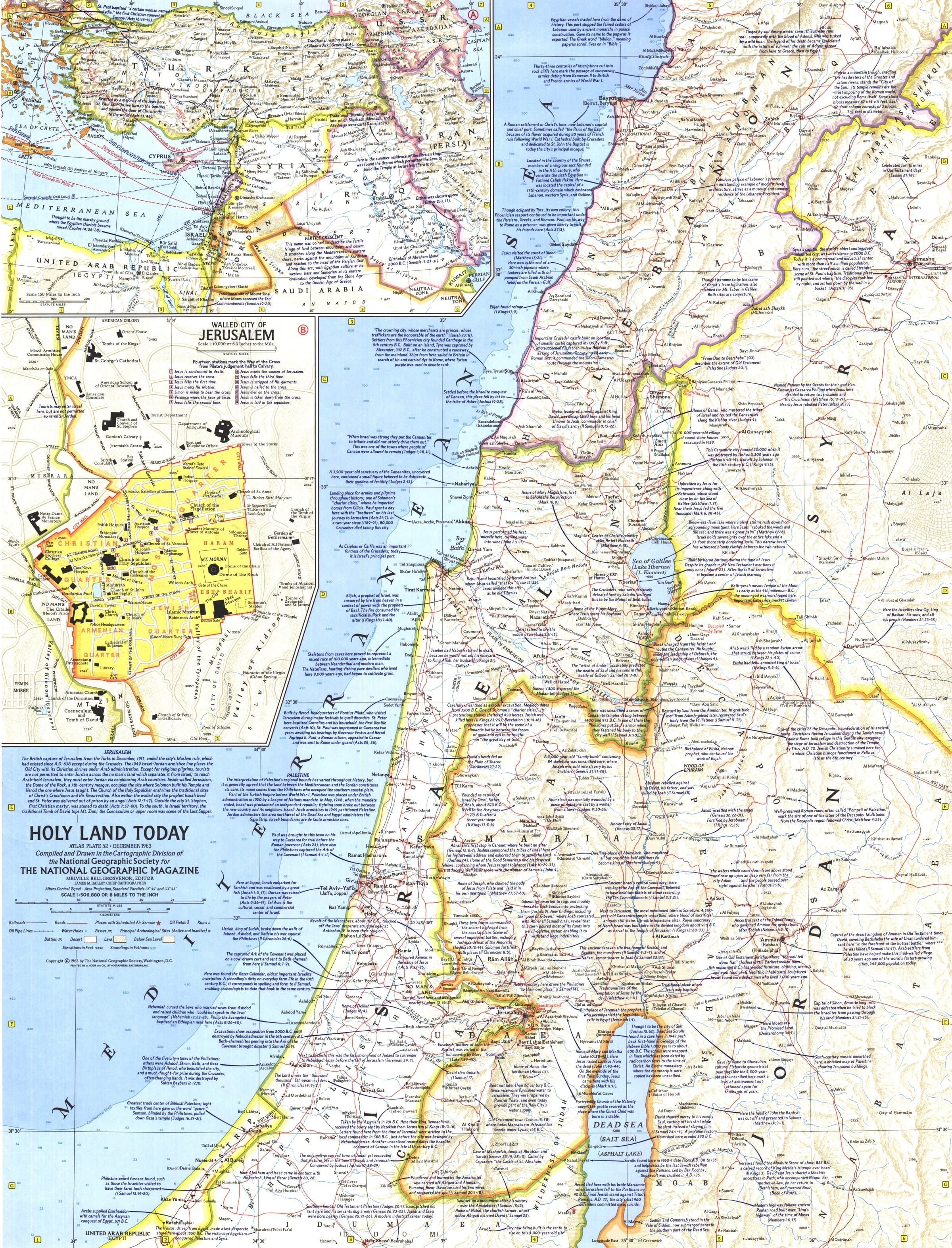
Holy Land Today Wall Map - Published 1963 by National Geographic
$59.95
or make 4 interest-free payments of
$14.99 AUD
fortnightly with
![]() More info
More info
Scale 1:506,880 | Published 1963 | Historical & Cultural Detail
Published in December 1963 by National Geographic, the Holy Land Today Wall Map is a richly detailed and historically significant cartographic work. Created to accompany the magazine articles "Crusader Road to Jerusalem" and "Conquest of the Holy City", this map blends geographic accuracy with layers of religious and historical context.
It presents the Holy Land in crisp political and physical detail, enriched with abundant historical notes that illuminate the region’s past. An inset map of the Middle East traces the routes of the Crusades, while a map of the Walled City of Jerusalem highlights the fourteen stations marking the Via Dolorosa — the path from Pilate’s hall to Calvary.
Ideal for collectors, educators, and those with a deep interest in religious history, this map is both a work of cartography and a piece of historical storytelling.
🗺️ Map Features
-
Detailed Depiction of the Holy Land – Clear political boundaries, major cities, towns, and natural features.
-
Inset: Crusade Routes – Middle East overview showing the paths of the Crusaders.
-
Inset: Walled City of Jerusalem – Marking the fourteen Stations of the Cross.
-
Historical Annotations – Text notes throughout provide cultural and historical context.
-
1963 National Geographic Quality – Precise cartography and rich, period-accurate colour palette.
✨ Available Finishes
| Format | Description |
|---|---|
| 🖨️ Paper (160 gsm) | Heavyweight matte-coated paper — perfect for framing under glass. |
| 🧼 Laminated (Encapsulated) | Fully sealed between two sheets of 80-micron gloss laminate for a wipe-clean, tear-resistant finish. |
| 🪵 Laminated with Wooden Hang Rails | Laminated map mounted with natural lacquered timber rails (top and bottom) and a hanging cord — ready to hang. |
| 🖼️ Canvas (395 gsm) | HP Professional Matte Canvas with archival pigment-based inks. Rich in texture, fade-resistant, and gallery-quality. |
| 🪵 Canvas with Wooden Hang Rails | Canvas mounted with natural timber rails and a hanging cord for a timeless, ready-to-display presentation. |
🔨 Please allow up to 10 working days for delivery of hang-railed maps, as each is professionally mounted by our custom framer.
📐 Specifications
| Feature | Detail |
|---|---|
| Title | Holy Land Today Wall Map |
| Publisher | National Geographic |
| Published | December 1963 |
| Scale | 1:506,880 |
| Dimensions | 481 mm (W) x 631 mm (H) |
| Materials | 160 gsm paper / 80-micron gloss laminate / 395 gsm HP Matte Canvas |
| Origin | Printed and professionally finished in Australia |
💡 Why You’ll Love This Map
✔️ A rare 1963 National Geographic map — a piece of cartographic history
✔️ Includes both geographic and religious landmarks
✔️ Beautiful insets on Crusade routes and the Walled City of Jerusalem
✔️ Available in five premium finishes, from frame-ready prints to ready-to-hang canvas
✔️ Fade-resistant and durable for long-term preservation
🎯 Perfect For
-
Collectors – A genuine 1963 publication from National Geographic
-
Religious Educators & Institutions – Ideal for teaching Biblical and Crusader history
-
Libraries & Archives – Adds historical depth to Middle Eastern collections
-
Home Display – A meaningful decorative piece with historical resonance
🚚 Delivery
-
Paper, Laminated, Canvas: Ships within 1–2 business days
-
Hang-railed Maps (Laminated or Canvas): Ships within 10 working days (custom-mounted)
-
Packaging: Rolled in a heavy-duty postal tube for safe, crease-free delivery
This Holy Land Today Wall Map is not just a geographic reference — it’s a historical artefact, a teaching tool, and a beautifully crafted work from one of the world’s most trusted mapmakers.
👉 Order today and own a piece of 20th-century cartographic history.
Frequently Asked Questions
What are the dimensions of the Holy Land Today Wall Map - Published 1963 by National Geographic?
Mapworld wall maps range from standard 700×1000mm to large-format 1000×1430mm Supermaps. The exact dimensions for this map are shown in the product title. Where multiple sizes are available, select your preferred size when adding to cart.
Is this wall map available laminated?
Many Mapworld wall maps are available in paper, laminated, or framed finishes. Check the product options when adding to cart. Laminated maps are wipe-clean and more durable.
Is this the latest edition?
Mapworld stocks the most current editions available from all publishers. Edition year is shown in the product title where applicable. Mapworld updates its catalogue as new editions are released.
Can I write on or pin this wall map?
Laminated wall maps can be written on with whiteboard markers and wiped clean. Paper maps can be pinned on a corkboard. Choose a laminated option for a writeable surface.
Does Mapworld ship the Holy Land Today Wall Map - Published 1963 by National Geographic across Australia?
Yes, Mapworld ships Australia-wide. Standard shipping is a flat $7 rate, with free standard shipping on orders over $75. Express options are available at checkout. Most orders placed before 2pm AEST on weekdays are dispatched same day.
Related Items


© 2026 Mapworld. Website designed by Genie Media
X