Civilizations Timeline | Archaeological Focus | Premium Finishes
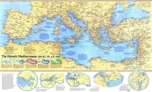
Journey through 2,300 years of Mediterranean history with National Geographic’s Historic Mediterranean Wall Map, published in December 1982. From the rise of the ancient Greeks and Phoenician traders to the heights of the Roman Empire, the Byzantine era, and the dawn of the Renaissance, this map presents a richly annotated portrait of the cultures, expansions, and encounters that shaped the region. Created as a companion to the acclaimed “Mediterranean Seafloor” plate and three in-depth features on the sea, it pairs clear, elegant cartography with concise historical notes and site labels that invite closer study and endless fascination.
🗺️ Map Features
Pan-Mediterranean Historical View (800 BC–AD 1500)
Track major periods—Greek colonization, Carthaginian influence, Roman consolidation, Byzantine continuity, and medieval polities—across Europe, North Africa, and the Near East.
Archaeological & Cultural Highlights
Key ancient cities and sites (e.g., classical theaters, temples, ports, and fortified towns) are identified to help connect material culture with the historical record.
Trade, Routes & Realms
See the sea lanes, overland corridors, and strategic straits that powered commerce and conquest—from Hellenistic networks to late-medieval trade hubs.
Readable, Scholarly Cartography
National Geographic’s renowned design balances clarity and density: region names, historical references, and place labels are laid out for quick scanning at wall distance and close-up study.
Companion Edition (1982)
Published alongside the Mediterranean Seafloor map and feature articles, this plate situates history above the seabed topography explored in the companion map.
Content reflects the scholarly understanding and nomenclature at the time of publication (1982).
✨ Available Finishes
| Format | Description |
|---|---|
| 📜 Paper (160 gsm) | Heavyweight matte-coated stock—ideal for framing under glass. |
| 🧼 Laminated (Encapsulated) | Fully sealed in 80-micron gloss laminate for a durable, wipe-clean surface. |
| 🪵 Laminated with Wooden Hang Rails | Laminated map mounted with lacquered natural timber rails (top & bottom) and a hanging cord—ready to display. |
| 🖼️ Canvas (395 gsm) | Printed on HP Professional Matte Canvas with archival pigment inks—textured, fade-resistant, gallery-quality. |
| 🪵 Canvas with Wooden Hang Rails | Canvas finished with lacquered timber rails and hanging cord for a timeless, frame-free presentation. |
🔨 Hang-railed maps are made to order—please allow up to 10 working days for professional mounting.
📐 Specifications
| Feature | Detail |
|---|---|
| Title | Historic Mediterranean Wall Map — 800 BC to AD 1500 |
| Publisher | National Geographic |
| Published | December 1982 |
| Map Type | Historical / Archaeological Reference |
| Scale | 1:4,730,000 |
| Dimensions | 934 mm (W) × 573 mm (H) |
| Orientation | Landscape |
| Materials | Paper, Laminated, Canvas; optional Timber Hang Rails |
| Printing | Archival pigment-based inks, fade-resistant |
| Printed & Mounted In | Australia |
💡 Why You’ll Love It
-
Museum-worthy wall piece that doubles as a study reference
-
Richly annotated without overwhelming the eye
-
Perfect for classrooms, libraries, studios, or the history-minded home
-
Multiple premium finishes to match scholarly or decorative settings
-
A conversation-starter that rewards repeated viewing
🚚 Delivery
-
Paper, Laminated & Canvas (rolled): Typically ships within 1–2 business days
-
Hang-railed versions: Made to order; allow up to 10 working days
-
Packaging: Securely protected to arrive in pristine condition
Relive the story of the Mediterranean world—from classical antiquity to the late Middle Ages—on a map that blends beauty, accuracy, and historical depth.
👉 Add this definitive 1982 National Geographic classic to your wall today.


