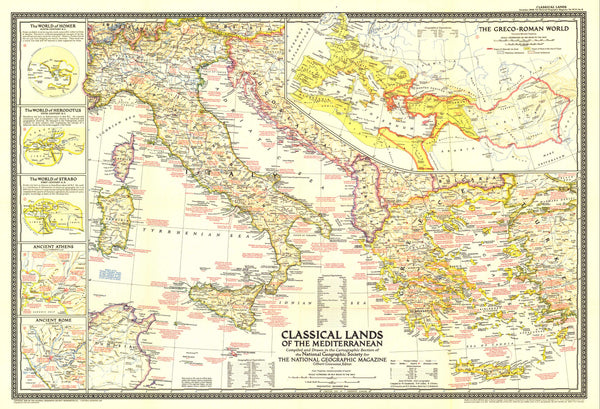
Classical Worlds & Empires — Classical Lands of the Mediterranean Wall Map (1949)
A richly annotated portrait of the ancient Mediterranean, issued by National Geographic in 1949. This elegant sheet blends clear period cartography with abundant historical notes and finely drawn insets—Ancient Athens, Ancient Rome, and the Roman Empire—all framed by a decorative border featuring the twelve signs of the zodiac. Educational and beautiful in equal measure.
More Than a Map – A Window onto Antiquity
Perfect for historians, classicists, educators, designers, and collectors, this map functions like a compact classical atlas. Trace trade routes and imperial reach, situate legendary cities, and compare political geographies across eras. It invites study and conversation in classrooms, libraries, studios, and homes.
Premium Materials & Finishes
🌟 Archival Paper Print
Printed on heavyweight 160gsm archival-grade paper.
Matte finish reduces glare and preserves crisp labels—ideal for framing under glass.
💎 Laminated Edition
Encapsulated in two sheets of 80-micron gloss laminate (true thermal bonding).
Moisture-resistant, wipe-clean—great for classrooms and high-use spaces.
Optional Natural Timber Hang Rails: lacquered rails with a fitted cord for a ready-to-hang display. (Please allow up to 10 working days with hang rails.)
🏆 Museum-Quality Canvas
Printed on 395gsm HP Professional Matte Canvas for rich texture and durability.
Pigment-based, fade-resistant inks keep tones deep and linework crisp for decades.
Optional Natural Timber Hang Rails: lacquered to highlight the grain; top cord for effortless hanging. (Please allow up to 10 working days with hang rails.)
Specifications
| Feature | Details |
|---|---|
| Title | Classical Lands of the Mediterranean Wall Map |
| Publisher | National Geographic |
| Original Publication | 1949 |
| Scale | 1:2,750,000 |
| Cartographic Content | Historical notes; insets of Ancient Athens, Ancient Rome & Roman Empire; zodiac border |
| Map Size | 809 mm (W) × 553 mm (H) |
| Available Formats | Paper, Laminated, Canvas |
| Paper Weight | 160gsm archival-quality |
| Laminate | 2 × 80-micron gloss laminate sheets (encapsulated) |
| Canvas Weight | 395gsm HP Professional Matte Canvas |
| Inks | Pigment-based, fade-resistant |
| Optional Hang Rails | Available on Laminated & Canvas (lead time up to 10 working days) |
| Origin | Made in Australia |
Why Choose This Map
✔ Classical Focus: A curated view of the ancient Mediterranean with expert insets.
✔ Scholarly & Decorative: Museum-worthy presence; richly informative at close range.
✔ Authentic Period Edition: A 1949 snapshot published in a time of renewed interest in classical heritage.
✔ Archival Craft: Premium stocks and inks preserve contrast, labels, and linework for years to come.
Our Commitment
Every map is printed locally in Australia, colour-checked, hand-inspected, and carefully packed. From press to wall, we prioritise fidelity, durability, and beauty—so your map informs, inspires, and endures.
Bring the classical world into focus. Order the Classical Lands of the Mediterranean Wall Map (1949) today—a faithful, display-ready classic that turns a room into a conversation.


