- Australia ▾
- Topographic
▾
- Australia AUSTopo 250k (2024)
- Australia 50k Geoscience maps
- Australia 100k Geoscience maps
- Australia 250k Geoscience maps
- Australia 1.1m Geoscience maps
- New Zealand 50k maps
- New Zealand 250k maps
- New South Wales 25k maps
- New South Wales 50k maps
- New South Wales 100k maps
- Queensland 10k maps
- Queensland 25k maps
- Queensland 50k maps
- Queensland 100k maps
- Compasses
- Software
- GPS Systems
- Orienteering
- International ▾
- Wall Maps
▾
- World
- Australia & New Zealand
- Countries, Continents & Regions
- Historical
- Vintage National Geographic
- Australian Capital Territory
- New South Wales
- Northern Territory
- Queensland
- South Australia
- Tasmania
- Victoria
- Western Australia
- Celestial
- Children's
- Mining & Resources
- Wine Maps
- Healthcare
- Postcode Maps
- Electoral Maps
- Nautical ▾
- Flags
▾
- Australian Flag Sets & Banners
- Flag Bunting
- Handwavers
- Australian National Flags
- Aboriginal Flags
- Torres Strait Islander Flags
- International Flags
- Flagpoles & Accessories
- Australian Capital Territory Flags
- New South Wales Flags
- Northern Territory Flags
- Queensland Flags
- South Australia Flags
- Tasmania Flags
- Victoria Flags
- Western Australia Flags
- Gifts ▾
- Globes ▾
Dear valued customer. Please note that our checkout is not supported by old browsers. Please use a recent browser to access all checkout capabilities


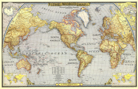
World Wall Map 1935 by National Geographic
$69.95
or make 4 interest-free payments of
$17.49 AUD
fortnightly with
![]() More info
More info
Hemispheres, Routes & Relief — World Wall Map (1935)
A snapshot of the interwar world, rendered with clarity and restraint. Published by National Geographic in 1935, this world sheet presents the Eastern and Western Hemispheres separately using the Azimuthal Equal-Area projection to convey true comparative area across continents. Thousands of place names (including capitals), railway lines, airplane routes, canals, glaciers, plus elevations, depressions, and ocean depths are set out in clean, legible cartography that rewards both room-distance viewing and close study. It’s the fabric of a connected world—accurate, navigable, and unmistakably of its era—made to study, admire, and display.
More Than a Map – A Testament to History
This isn’t just wall art—it’s a reference frame for global movement and measurement in the 1930s. Explore hemisphere panels, a detailed Earth chart with facts on mass, continental areas, mountain heights, and ocean depths, and dedicated Northern and Southern Hemisphere insets. Time-zone diagrams for both hemispheres complete the picture of a world synchronising travel and trade. Ideal for educators, planners, historians, designers, and collectors, this sheet stands alone beautifully and pairs perfectly with modern world maps for then-and-now comparison.
Hang it in studios, libraries, classrooms, museums, offices, or at home to invite reflection, study, and conversation.
Premium Materials & Finishes
We treat history with the respect it deserves. That’s why we offer multiple formats, each produced using high-quality materials and modern archival printing.
🌟 Archival Paper Print
Printed on heavyweight 160gsm archival-grade paper.
Smooth matte finish reduces glare and preserves fine linework and small labels.
Ideal for framing under glass—clean, timeless, and built to last.
💎 Laminated Edition
Encapsulated in two sheets of 80-micron gloss laminate using true thermal bonding—not just surface lamination.
Moisture-resistant, wipe-clean surface—perfect for classrooms and high-traffic reference spaces.
Optional Natural Timber Hang Rails: lacquered rails with a fitted hanging cord provide a polished, ready-to-hang presentation—no frame required. (Please allow up to 10 working days for delivery with hang rails.)
🏆 Museum-Quality Canvas
Printed on heavyweight 395gsm HP Professional Matte Canvas for rich texture and exceptional strength.
Pigment-based, fade-resistant inks deliver deep tone and crisp typography that endure for generations.
Optional Natural Timber Hang Rails: lacquered to enhance the wood grain and protect against wear; top cord for effortless hanging—elegant in any setting. (Please allow up to 10 working days for delivery with hang rails.)
Specifications
| Feature | Details |
|---|---|
| Title | World Wall Map |
| Series | National Geographic single-sheet world map |
| Original Publication | 1935 |
| Projection | Azimuthal Equal-Area, separate Eastern & Western Hemispheres |
| Cartographic Content | Thousands of place names (incl. capitals); railway lines; airplane routes; canals; glaciers; elevations & depressions; ocean depths; Earth chart of global facts; separate Northern & Southern Hemisphere insets; time-zone insets for both hemispheres |
| Map Size | 1107 mm (W) × 579 mm (H) |
| Available Formats | Paper, Laminated, Canvas |
| Paper Weight | 160gsm archival-quality |
| Laminate | 2 × 80-micron gloss laminate sheets (encapsulated) |
| Canvas Weight | 395gsm HP Professional Matte Canvas |
| Inks | Pigment-based, fade-resistant |
| Optional Hang Rails | Available on Laminated & Canvas (lead time up to 10 working days) |
| Origin | Made in Australia |
Why Choose This Map
✔ Equal-Area Accuracy: Hemisphere panels on the Azimuthal Equal-Area projection show landmasses at true comparative size.
✔ Network Insight: Air and rail overlays capture interwar travel and trade at a glance.
✔ Layered Context: Earth chart, hemisphere insets, and time-zone diagrams deepen understanding.
✔ Clarity at Scale: Classic National Geographic styling with thousands of legible place names.
✔ Archival Craft: Premium substrates and inks preserve contrast, labels, and linework for decades.
Our Commitment
We believe that preserving history is as important as telling it. Every map is printed locally in Australia using state-of-the-art technology, carefully checked by hand, and packed with care. From the moment it leaves our workshop to the day it hangs on your wall, we ensure quality you can trust and a legacy you’ll be proud to share.
Bring the interwar world into focus. Order the World Wall Map (1935) today—a faithful, beautifully produced sheet that turns a room into a conversation.