- Australia ▾
- Topographic
▾
- Australia AUSTopo 250k (2025)
- Australia 50k Geoscience maps
- Australia 100k Geoscience maps
- Australia 250k Geoscience maps
- Australia 1:1m Geoscience maps
- New Zealand 50k maps
- New Zealand 250k maps
- New South Wales 25k maps
- New South Wales 50k maps
- New South Wales 100k maps
- Queensland 10k maps
- Queensland 25k maps
- Queensland 50k maps
- Queensland 100k maps
- Compasses
- Software
- GPS Systems
- Orienteering
- International ▾
- Wall Maps
▾
- World
- Australia & New Zealand
- Countries, Continents & Regions
- Historical
- Vintage National Geographic
- Australian Capital Territory
- New South Wales
- Northern Territory
- Queensland
- South Australia
- Tasmania
- Victoria
- Western Australia
- Celestial
- Children's
- Mining & Resources
- Wine Maps
- Healthcare
- Postcode Maps
- Electoral Maps
- Nautical ▾
- Flags
▾
- Australian Flag Sets & Banners
- Flag Bunting
- Handwavers
- Australian National Flags
- Aboriginal Flags
- Torres Strait Islander Flags
- International Flags
- Flagpoles & Accessories
- Australian Capital Territory Flags
- New South Wales Flags
- Northern Territory Flags
- Queensland Flags
- South Australia Flags
- Tasmania Flags
- Victoria Flags
- Western Australia Flags
- Gifts ▾
- Globes ▾
Dear valued customer. Please note that our checkout is not supported by old browsers. Please use a recent browser to access all checkout capabilities


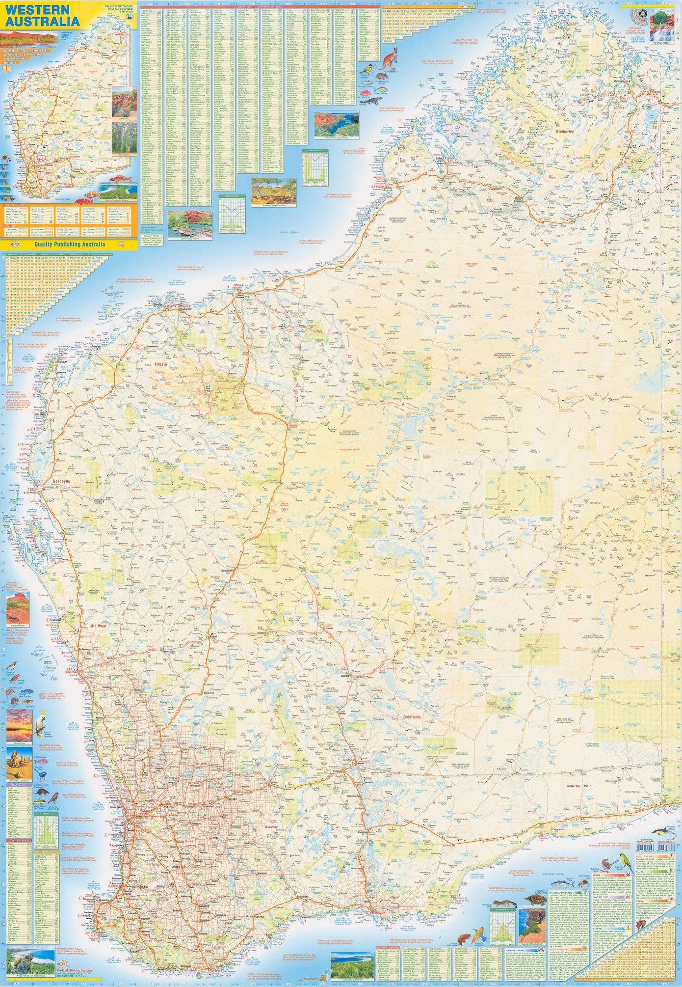
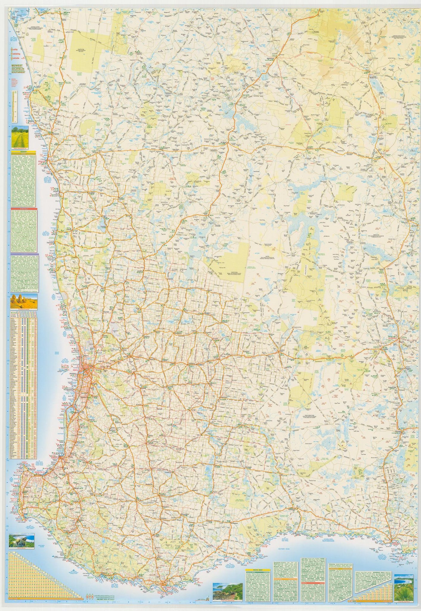
Western Australia & Southern WA Large QPA 710 x 1010mm Laminated Wall Map
$89.95 $99.95
or make 4 interest-free payments of
$22.49 AUD
fortnightly with
![]() More info
More info
Dual-Sided | Durable Gloss Laminate | Size: 1010 mm (H) x 710 mm (W)
Explore the sweeping expanse of Australia's largest state with this exceptionally detailed and beautifully rendered wall map by QPA Cartographics. Covering both the entire state of Western Australia and a close-up focus on the highly trafficked southern quadrant, this laminated map is as functional as it is visually striking—perfect for travel planning, logistics, education, business, or display in any room.
🌏 Two Maps in One — Macro View + Regional Detail
-
Side A: Full Western Australia (Scale 1:2,500,000)
Gain a comprehensive view of the state—from the Kimberley and Pilbara to the Nullarbor Plain. This side includes:-
All major highways, arterial roads, and rail lines
-
Clearly marked towns, rivers, ranges, and deserts
-
National parks, marine parks, and other conservation areas
-
Administrative boundaries and geographic landmarks
-
Distance markers for route planning
-
-
Side B: Southern Western Australia Focus (Shark Bay to Esperance)
A larger-scale inset of the heavily visited and populated quadrant covering:-
Geraldton – Kalgoorlie – Albany – Esperance
-
Excellent for detailed logistics, tourism, and road navigation in the southwest
-
Townships, road networks, coastline, and infrastructure shown in finer clarity
-
🗺️ Ideal For:
✅ Travelers & Road Trippers – Plan scenic drives, camping routes, and coastal adventures
✅ Freight & Logistics Professionals – View critical regional transport routes
✅ Educators & Students – Use as a reference in classrooms or geography lessons
✅ Home or Office Display – Stylish and informative, fits perfectly in meeting rooms or studies
✅ Business & Sales Teams – Manage territories, service zones, and remote operations
📌 Features at a Glance
-
High clarity cartography with intuitive colour coding
-
Fully updated place names and infrastructure
-
Highlighted state/national routes, regional highways, and outback tracks
-
Shaded relief showing Western Australia’s dramatic terrain
-
Ideal coverage for regional travel, planning, and location awareness
🖼️ Premium Laminated Finish
This map is fully encapsulated in 80-micron gloss laminate, making it:
-
💧 Water-resistant and wipeable – use with whiteboard markers
-
💪 Tear-resistant and durable – ideal for heavy handling
-
📌 Perfect for pinning or wall-mounting
-
🧼 Easy to clean and long-lasting
Whether you want to mark favourite destinations, chart out logistics, or simply admire the vastness of WA, this map is made to endure and impress.
📐 Product Specifications
| Specification | Details |
|---|---|
| Map Dimensions | 1010 mm (Height) × 710 mm (Width) |
| Main Map Scale | 1:2,500,000 (Western Australia) |
| Inset Map Scale | Larger-scale focus on Shark Bay to Esperance |
| Material | 80-micron gloss laminated |
| Format | Dual-sided flat wall map |
| Publisher | QPA (Cartographics Australia) |
| Country of Origin | Proudly Made in Australia |
✨ Why Choose This Map
✔️ Combines wide coverage with regional detail
✔️ Professional-grade lamination for longevity
✔️ Designed, printed, and published in Australia
✔️ Informative, attractive, and ready to display
✔️ A must-have for anyone with ties to Western Australia
From red desert trails to sunlit coastal drives—this large-format laminated wall map brings Western Australia’s epic scale into sharp focus. A reliable reference, a stunning display, and a meaningful connection to one of the world’s last great frontiers.
Frequently Asked Questions
What are the dimensions of the Western Australia & Southern WA Large QPA 710 x 1010mm Laminated Wall ?
Mapworld wall maps range from standard 700×1000mm to large-format 1000×1430mm Supermaps. The exact dimensions for this map are shown in the product title. Where multiple sizes are available, select your preferred size when adding to cart.
Is this wall map available laminated?
Many Mapworld wall maps are available in paper, laminated, or framed finishes. Check the product options when adding to cart. Laminated maps are wipe-clean and more durable.
Is this the latest edition?
Mapworld stocks the most current editions available from all publishers. Edition year is shown in the product title where applicable. Mapworld updates its catalogue as new editions are released.
Can I write on or pin this wall map?
Laminated wall maps can be written on with whiteboard markers and wiped clean. Paper maps can be pinned on a corkboard. Choose a laminated option for a writeable surface.
Does Mapworld ship the Western Australia & Southern WA Large QPA 710 x 1010mm Laminated Wall across Australia?
Yes, Mapworld ships Australia-wide. Standard shipping is a flat $7 rate, with free standard shipping on orders over $75. Express options are available at checkout. Most orders placed before 2pm AEST on weekdays are dispatched same day.
Related Items


© 2026 Mapworld. Website designed by Genie Media
X