- Australia ▾
- Topographic
▾
- Australia AUSTopo 250k (2025)
- Australia 50k Geoscience maps
- Australia 100k Geoscience maps
- Australia 250k Geoscience maps
- Australia 1.1m Geoscience maps
- New Zealand 50k maps
- New Zealand 250k maps
- New South Wales 25k maps
- New South Wales 50k maps
- New South Wales 100k maps
- Queensland 10k maps
- Queensland 25k maps
- Queensland 50k maps
- Queensland 100k maps
- Compasses
- Software
- GPS Systems
- Orienteering
- International ▾
- Wall Maps
▾
- World
- Australia & New Zealand
- Countries, Continents & Regions
- Historical
- Vintage National Geographic
- Australian Capital Territory
- New South Wales
- Northern Territory
- Queensland
- South Australia
- Tasmania
- Victoria
- Western Australia
- Celestial
- Children's
- Mining & Resources
- Wine Maps
- Healthcare
- Postcode Maps
- Electoral Maps
- Nautical ▾
- Flags
▾
- Australian Flag Sets & Banners
- Flag Bunting
- Handwavers
- Australian National Flags
- Aboriginal Flags
- Torres Strait Islander Flags
- International Flags
- Flagpoles & Accessories
- Australian Capital Territory Flags
- New South Wales Flags
- Northern Territory Flags
- Queensland Flags
- South Australia Flags
- Tasmania Flags
- Victoria Flags
- Western Australia Flags
- Gifts ▾
- Globes ▾
Dear valued customer. Please note that our checkout is not supported by old browsers. Please use a recent browser to access all checkout capabilities
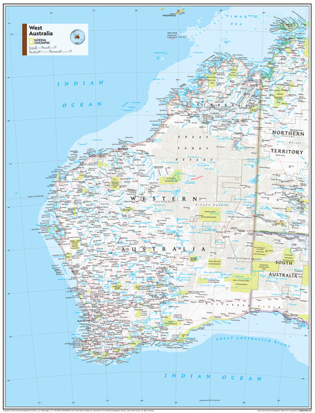
West Australia National Geographic Wall Map
$79.95
or make 4 interest-free payments of
$19.99 AUD
fortnightly with
![]() More info
More info
A Striking Political & Physical Map of Western Australia
Available in Paper, Laminated, and Canvas Editions
Step into the vast, sunburnt splendour of Western Australia with this beautifully rendered wall map from the cartographic masters at National Geographic. Showcasing both political boundaries and physical geography in exquisite detail, this map is more than a reference—it's a celebration of one of the world’s last great frontiers.
Whether you’re planning road trips across the Kimberley, tracing mineral exploration zones near Kalgoorlie, or simply captivated by the rugged beauty of the Outback, this map delivers both visual impact and geographic precision. From the turquoise coastline of Ningaloo Reef to the red dirt trails of the Pilbara, Western Australia’s diverse and dramatic terrain is faithfully captured in National Geographic’s signature style.
🌟 Who Is This Map For?
-
Educators & Classrooms – Bring the region to life in geography and environmental studies lessons. Perfect for schools, TAFEs, and universities with a focus on Australian landscapes or natural resource management.
-
Adventurers & Road Trippers – A stunning planning companion for campers, grey nomads, and outback explorers following the coast, Goldfields, or Nullarbor routes.
-
Business & Logistics – An essential tool for those in mining, logistics, or agriculture, providing a quick reference for towns, terrain, and infrastructure.
-
Home & Office Decorators – Elevate your wall space with a timeless piece that’s equal parts informative and inspiring. A great gift for lovers of Australia, map collectors, or expats abroad.
-
Government & Planning Agencies – Ideal for regional development teams or tourism operators seeking a high-quality wall reference.
🧭 Key Features
| Feature | Description |
|---|---|
| Projection | Drawn using the Azimuthal Equidistant projection, ensuring all points are proportionally correct distances from the central point |
| Detail | Shows both political boundaries (towns, cities, roads) and physical features (terrain, rivers, deserts, reefs) |
| Design | Uses National Geographic’s iconic bright colour palette, crisp typography, and stunning shaded relief for a clear and engaging visual experience |
| Educational Value | Featured in the 11th Edition of National Geographic's World Atlas, now offered as a standalone product |
| Inset Details | Includes detailed relief of coastal areas, arid interiors, and natural features across the state |
🖼️ Finishing Options
| Finish Type | Description |
|---|---|
| Paper (160 gsm) | High-quality heavyweight coated paper – ideal for framing under glass or for use with pins in creative or workspaces |
| Laminated | Encapsulated in dual 80-micron gloss laminate – waterproof, durable, and compatible with whiteboard markers or Mark-It-Dots |
| Canvas (395 gsm) | Printed on HP Professional Matte Canvas using archival pigment-based inks – fade-resistant and tactile for museum-grade presentation |
| Laminated or Canvas with Hang Rails | Includes natural timber hang rails (top and bottom), with a hanging cord for effortless wall display – ideal for home, studio, or boardroom |
📐 Specifications
-
Sizes:
-
Standard: 700 mm (W) × 1000 mm (H)
-
Large: 1000 mm (W) × 1400 mm (H)
-
-
Scale: Custom regional, based on physical and political data sets
-
Published: 2019 by National Geographic
-
Printed In: Australia
🛠️ Notes on Delivery
Please allow up to 10 working days for laminated or canvas maps with hang rails. These versions are hand-finished by our professional framer in Sydney to ensure exceptional quality.
🌏 Why Choose This Map?
✔️ A compelling blend of scientific accuracy and artistic design
✔️ Adds gravitas and sophistication to any room or learning space
✔️ Printed with fade-resistant Hewlett-Packard pigment-based inks
✔️ Flexible display options – from practical classroom use to gallery-style canvas art
✔️ Created by one of the world’s most respected cartographic institutions
Celebrate the majestic scale of Western Australia—its coastlines, deserts, and outback towns—on a map you’ll return to again and again. Whether for inspiration, education, or orientation, this map is an enduring homage to the grandeur of the west.


