- Australia ▾
- Topographic
▾
- Australia AUSTopo 250k (2025)
- Australia 50k Geoscience maps
- Australia 100k Geoscience maps
- Australia 250k Geoscience maps
- Australia 1:1m Geoscience maps
- New Zealand 50k maps
- New Zealand 250k maps
- New South Wales 25k maps
- New South Wales 50k maps
- New South Wales 100k maps
- Queensland 10k maps
- Queensland 25k maps
- Queensland 50k maps
- Queensland 100k maps
- Western Australia 25k maps
- Western Australia 50k maps
- Western Australia 100k maps
- Compasses
- Software
- GPS Systems
- International ▾
- Wall Maps
▾
- World
- Australia & New Zealand
- Countries, Continents & Regions
- Historical
- Vintage National Geographic
- Australian Capital Territory
- New South Wales
- Northern Territory
- Queensland
- South Australia
- Tasmania
- Victoria
- Western Australia
- Celestial
- Children's
- Mining & Resources
- Wine Maps
- Healthcare
- Postcode Maps
- Electoral Maps
- Nautical ▾
- Flags
▾
- Australian Flag Sets & Banners
- Flag Bunting
- Handwavers
- Australian National Flags
- Aboriginal Flags
- Torres Strait Islander Flags
- International Flags
- Flagpoles & Accessories
- Australian Capital Territory Flags
- New South Wales Flags
- Northern Territory Flags
- Queensland Flags
- South Australia Flags
- Tasmania Flags
- Victoria Flags
- Western Australia Flags
- Gifts ▾
- Globes ▾
Dear valued customer. Please note that our checkout is not supported by old browsers. Please use a recent browser to access all checkout capabilities


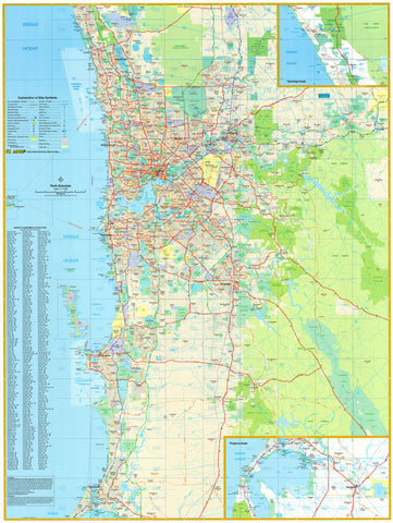
Perth UBD 662 Map 690 x 1000mm Laminated Wall Map
$99.00
or make 4 interest-free payments of
$24.75 AUD
fortnightly with
![]() More info
More info
A beautifully detailed and highly functional map of Perth — perfect for the home, office, school, or professional environment.
Whether you’re relocating to Perth, operating a business, planning property investments, or simply want to explore the region in depth, the UBD Gregory’s Perth City & Suburbs Wall Map is an invaluable resource. With its dual focus on street-level precision and metropolitan context, this double-sided map is designed to help you understand, navigate, and visualise the Perth area with confidence.
Offering the clarity of UBD cartography, durability through lamination, and a range of display options, this map suits anyone who values practicality, aesthetics, and reliable local information.
🗺️ Side A: Central Perth – Street-Level Detail
Scale: 1:25,000
This side provides fine-scale mapping of central Perth and its surrounding suburbs, covering a 10km radius from the CBD. The area stretches:
-
From Trigg in the northwest
-
Across to Noranda in the northeast
-
Down to North Coogee in the southwest
-
Over to Victoria Park in the southeast
Features include:
-
All street names, major roads, and key intersections
-
Public infrastructure such as schools, hospitals, rail lines, and shopping precincts
-
Natural features like parks, rivers, and reserves
-
An ideal map for house hunters, urban service providers, estate agents, and local residents
🏙️ Side B: Greater Perth – Suburban Overview
Scale: 1:114,000
On the reverse, a larger-scale map delivers a 75km-radius view of metropolitan Perth, extending:
-
North to Quinns Rocks
-
South to Mandurah
-
Includes a detailed inset of Pinjarra
What it shows:
-
Major arterial roads and highways, including key bypasses and transport links
-
Suburb boundaries and postcode zones
-
Built-up residential areas, industrial estates, and protected national parkland
-
All suburb names listed in a comprehensive index, cross-referenced by postcode for ease of navigation
This is an ideal planning map for:
-
Council zoning and logistics teams
-
Property developers and investors
-
Schools, libraries, and research centres
-
Anyone needing a suburb-level reference for Perth’s sprawling metro area
🖨️ Print Quality & Lamination
Both sides of the map are printed on high-quality stock and fully encapsulated in two sheets of 80-micron gloss laminate, offering:
-
Waterproof, tear-resistant protection
-
The ability to draw or write on the surface using whiteboard markers
-
Compatibility with Map Dots, pins, or stickers to highlight locations or routes
-
Easy wipe-clean usability for frequent updates or collaborative planning
🪵 Hanging Options
For display, the map can be supplied:
-
Flat laminated (perfectly smooth, suitable for wall-mounting or framing) – $99.00 (UBD Edition 2022)
-
Laminated folded (previously folded map that’s been laminated – will show some crease lines) – $49.95 (Laminated 2024 Edition)
Optional wooden hang rails can be added:
-
Attached top and bottom, with a natural lacquered timber finish
-
Hanging cord included on the top rail for easy wall mounting
-
Allow 10 working days for delivery of hang-railed versions, as they’re custom-fitted by our framer
📐 Map Specifications
-
Scales:
-
Central Perth: 1:25,000
-
Greater Perth: 1:114,000
-
-
Size: 690 mm wide x 1000 mm high
-
Orientation: Portrait
-
Format: Double-sided, laminated
-
Publisher: UBD Gregory’s
-
Printed in: Australia
-
Latest Editions:
-
Flat laminated (2022 UBD): $99.00
-
Folded laminated (2024): $49.95
-
🎯 Ideal For:
-
Home buyers and renters exploring suburbs, school zones, or commute routes
-
Real estate agents needing a clear, accessible overview for clients
-
Urban planners and council staff visualising infrastructure and development areas
-
Small businesses planning deliveries or service areas
-
Schools and universities teaching Perth geography and urban development
-
New residents looking to familiarise themselves with the city layout
-
Interior decorators and map lovers wanting a functional and beautiful piece for the wall
✅ Why Choose the Perth City & Suburbs Wall Map?
-
Combines close-up clarity with big-picture context
-
Produced by Australia’s most trusted street directory publisher
-
Printed and laminated to Australian standards, ensuring lasting quality
-
Offers two display options to suit your budget and space
-
Provides a professional, polished look for any room or workspace
Whether you're buying, building, planning, or simply getting to know Perth better, this map puts the city in your hands — literally.
Detailed, durable, and designed for daily use — the UBD Perth City & Suburbs Wall Map is Perth made practical.
Frequently Asked Questions
What are the dimensions of the Perth UBD 662 Map 690 x 1000mm Laminated Wall Map?
Mapworld wall maps range from standard 700×1000mm to large-format 1000×1430mm Supermaps. The exact dimensions for this map are shown in the product title. Where multiple sizes are available, select your preferred size when adding to cart.
Is this wall map available laminated?
Many Mapworld wall maps are available in paper, laminated, or framed finishes. Check the product options when adding to cart. Laminated maps are wipe-clean and more durable.
Is this the latest edition?
Mapworld stocks the most current editions available from all publishers. Edition year is shown in the product title where applicable. Mapworld updates its catalogue as new editions are released.
Can I write on or pin this wall map?
Laminated wall maps can be written on with whiteboard markers and wiped clean. Paper maps can be pinned on a corkboard. Choose a laminated option for a writeable surface.
Does Mapworld ship the Perth UBD 662 Map 690 x 1000mm Laminated Wall Map across Australia?
Yes, Mapworld ships Australia-wide. Standard shipping is a flat $7 rate, with free standard shipping on orders over $75. Express options are available at checkout. Most orders placed before 2pm AEST on weekdays are dispatched same day.
Related Items


© 2026 Mapworld. Website designed by Genie Media
X