- Australia ▾
- Topographic
▾
- Australia AUSTopo 250k (2025)
- Australia 50k Geoscience maps
- Australia 100k Geoscience maps
- Australia 250k Geoscience maps
- Australia 1.1m Geoscience maps
- New Zealand 50k maps
- New Zealand 250k maps
- New South Wales 25k maps
- New South Wales 50k maps
- New South Wales 100k maps
- Queensland 10k maps
- Queensland 25k maps
- Queensland 50k maps
- Queensland 100k maps
- Compasses
- Software
- GPS Systems
- Orienteering
- International ▾
- Wall Maps
▾
- World
- Australia & New Zealand
- Countries, Continents & Regions
- Historical
- Vintage National Geographic
- Australian Capital Territory
- New South Wales
- Northern Territory
- Queensland
- South Australia
- Tasmania
- Victoria
- Western Australia
- Celestial
- Children's
- Mining & Resources
- Wine Maps
- Healthcare
- Postcode Maps
- Electoral Maps
- Nautical ▾
- Flags
▾
- Australian Flag Sets & Banners
- Flag Bunting
- Handwavers
- Australian National Flags
- Aboriginal Flags
- Torres Strait Islander Flags
- International Flags
- Flagpoles & Accessories
- Australian Capital Territory Flags
- New South Wales Flags
- Northern Territory Flags
- Queensland Flags
- South Australia Flags
- Tasmania Flags
- Victoria Flags
- Western Australia Flags
- Gifts ▾
- Globes ▾
Dear valued customer. Please note that our checkout is not supported by old browsers. Please use a recent browser to access all checkout capabilities
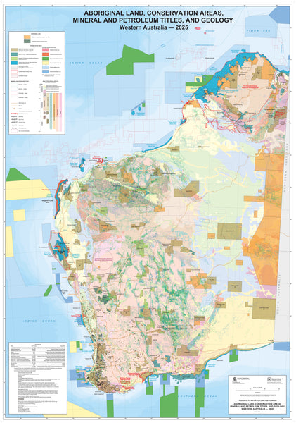
WA Aboriginal Land, Conservation Areas, Mineral and Petroleum Titles and Geology 1015 x 1450mm Wall Map
$129.95
or make 4 interest-free payments of
$32.49 AUD
fortnightly with
![]() More info
More info
Aboriginal Land | Conservation Areas | Mineral & Petroleum Titles | Geology
Size: 1015 mm (W) x 1450 mm (H)
An essential, oversized reference map showing the intersection of culture, conservation, industry, and geology across the vast landscape of Western Australia.
📜 A Comprehensive View of WA’s Land Systems
This expertly compiled wall map offers a powerful, layered visual of Western Australia’s land use and natural resource zones, bringing together key geographic and legal datasets in a single large-format display.
Developed for planning, education, and resource management, this map displays:
-
🟤 Aboriginal Land Trust areas and Native Title regions
-
🌿 Conservation parks, nature reserves, and marine protection zones
-
⚒️ Current and proposed mineral and petroleum leases
-
🪨 Geological structures, including basins, ridges, and faults
Whether you're an environmental consultant, a resource planner, or a land management student, this map is an invaluable visual tool for interpreting Western Australia’s unique land profile.
🔍 Map Highlights
-
📍 Shows overlapping land uses across the state
-
🌏 Combines cultural, conservation, industrial, and geological data
-
📚 Ideal for offices, schools, mines, councils, and resource agencies
-
🖋️ Professionally designed for clarity and readability at scale
-
🗂️ Consolidates complex information into one easy-to-reference display
🖨️ Premium Material & Display Options
Choose from three high-quality materials with optional hang rails for both laminated and canvas versions:
📄 160gsm Matte Paper
-
Crisp and smooth finish
-
Ideal for framing under glass
-
Ships rolled for protection
💧 Laminated – 80 Micron Gloss Encapsulation
-
Fully encapsulated front and back with 80-micron gloss laminate
-
Waterproof, tear-resistant, and wipe-clean
-
✅ Now available with optional timber hang rails for instant wall display
🖼️ 395gsm HP Professional Matte Canvas
-
Printed with fade-resistant pigment inks on archival-grade canvas
-
Stunning texture and colour richness
-
✅ Also available with optional natural timber hang rails
⏳ Please allow up to 10 working days for maps ordered with hang rails (laminated or canvas), as they are fitted by hand by our professional framer.
🪵 Optional Timber Hang Rails (Laminated & Canvas)
Upgrade your map with our beautiful natural timber hang rail system, available for both laminated and canvas formats:
-
🪵 Timber battens attached top and bottom
-
🧵 Top rail includes a sturdy hanging cord for simple display
-
🖐️ Custom-fitted by hand for a clean, balanced presentation
-
🌿 Natural lacquer finish complements both classic and modern interiors
Perfect for offices, workshops, public spaces, or home décor with a functional twist.
📐 Specifications
| Feature | Description |
|---|---|
| Map Title | WA Aboriginal Land, Conservation, Titles & Geology |
| Data Layers | Aboriginal Land, Conservation Areas, Mineral & Petroleum Titles, Geology |
| Published | Most recent available edition |
| Size | 1015 mm (W) x 1450 mm (H) |
| Material Options | 160gsm Paper / Laminated / Canvas |
| Laminated Format | 80-micron gloss laminate encapsulation |
| Canvas Format | 395gsm HP Professional Matte Canvas |
| Ink Type (Canvas) | Pigment-based, archival quality |
| Hang Rail Option | Available for Laminated and Canvas formats |
| Assembly Time | 10 working days for hang-railed maps |
| Printed & Framed | In Australia |
Perfect For:
-
🛢️ Mining & petroleum consultants
-
🌱 Environmental and land use planners
-
🧭 Cartographers and geologists
-
📚 Universities and research institutions
-
🏛️ Government and Indigenous affairs departments
-
🏢 Offices or boardrooms needing functional, impactful wall art
🇦🇺 Proudly Printed in Australia
All maps are printed, finished, and assembled in Australia using museum-grade materials and precision craftsmanship. Whether for professional use or educational display, this map represents the intersection of land, culture, and resource in one of the world’s most geologically diverse states.
🛒 Order Yours Today
-
Choose your format – Paper, Laminated, or Canvas
-
Select your finish – Rolled or with Timber Hang Rails (Laminated/Canvas)
-
Add to cart and display with pride
Explore Western Australia’s land story—where heritage, nature, and geology meet in one stunning, data-rich map.


