- Australia ▾
- Topographic
▾
- Australia AUSTopo 250k (2024)
- Australia 50k Geoscience maps
- Australia 100k Geoscience maps
- Australia 250k Geoscience maps
- Australia 1.1m Geoscience maps
- New Zealand 50k maps
- New Zealand 250k maps
- New South Wales 25k maps
- New South Wales 50k maps
- New South Wales 100k maps
- Queensland 10k maps
- Queensland 25k maps
- Queensland 50k maps
- Queensland 100k maps
- Compasses
- Software
- GPS Systems
- Orienteering
- International ▾
- Wall Maps
▾
- World
- Australia & New Zealand
- Countries, Continents & Regions
- Historical
- Vintage National Geographic
- Australian Capital Territory
- New South Wales
- Northern Territory
- Queensland
- South Australia
- Tasmania
- Victoria
- Western Australia
- Celestial
- Children's
- Mining & Resources
- Wine Maps
- Healthcare
- Postcode Maps
- Electoral Maps
- Nautical ▾
- Flags
▾
- Australian Flag Sets & Banners
- Flag Bunting
- Handwavers
- Australian National Flags
- Aboriginal Flags
- Torres Strait Islander Flags
- International Flags
- Flagpoles & Accessories
- Australian Capital Territory Flags
- New South Wales Flags
- Northern Territory Flags
- Queensland Flags
- South Australia Flags
- Tasmania Flags
- Victoria Flags
- Western Australia Flags
- Gifts ▾
- Globes ▾
Dear valued customer. Please note that our checkout is not supported by old browsers. Please use a recent browser to access all checkout capabilities


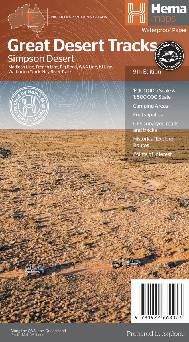
Great Desert Tracks Simpson Desert Hema
$14.95
Afterpay is only available for orders between $50.00 and $1000.00 More info
Your ultimate navigation tool for exploring one of Australia’s most iconic and remote outback landscapes.
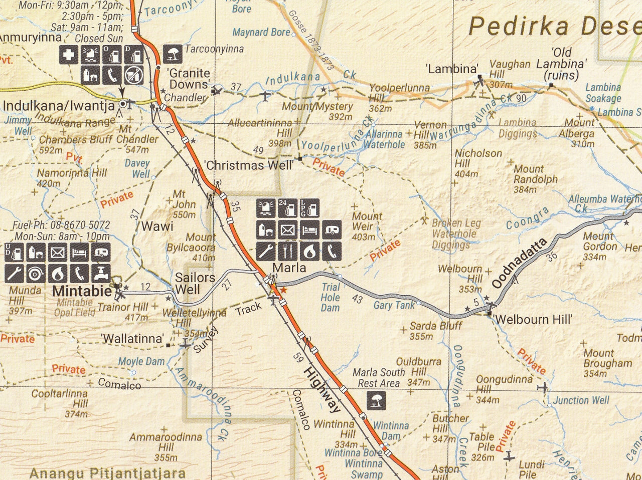
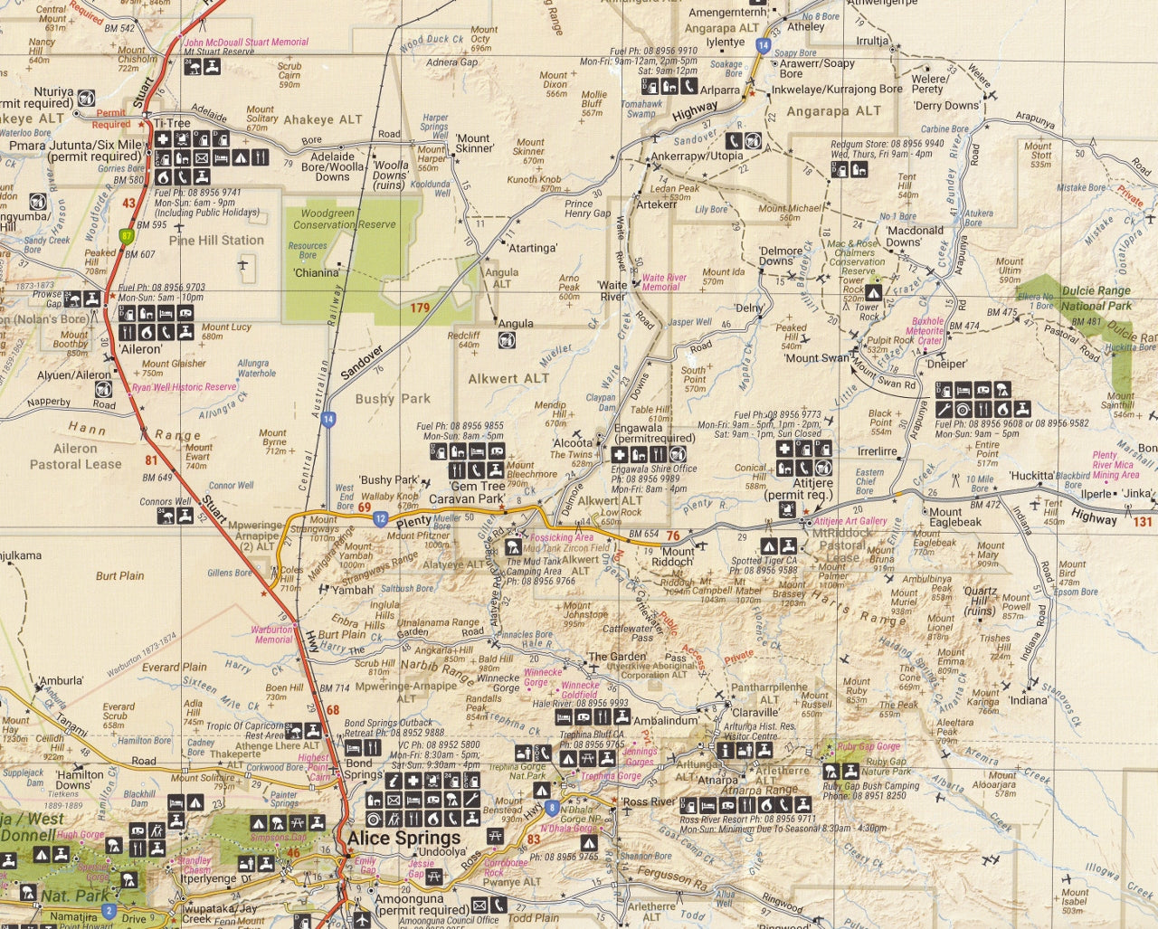
The Hema Great Desert Tracks Simpson Desert Map (9th Edition) is a must-have for any adventurer, four-wheel driver, or remote traveller planning to explore the Simpson Desert — one of the most challenging and awe-inspiring environments in Australia. Renowned for its towering red dunes, vast gibber plains, salt lakes, and historical tracks, the Simpson Desert demands careful preparation, and this map is your essential companion.
Created using GPS field data collected by the Hema Map Patrol, the map provides comprehensive and up-to-date information to help ensure a safe, enjoyable, and well-informed journey through one of the country’s most isolated regions.
🧭 Comprehensive Coverage
This map features dual-sided mapping designed for both high-detail navigation and broader trip planning:
-
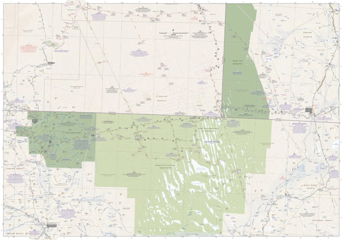
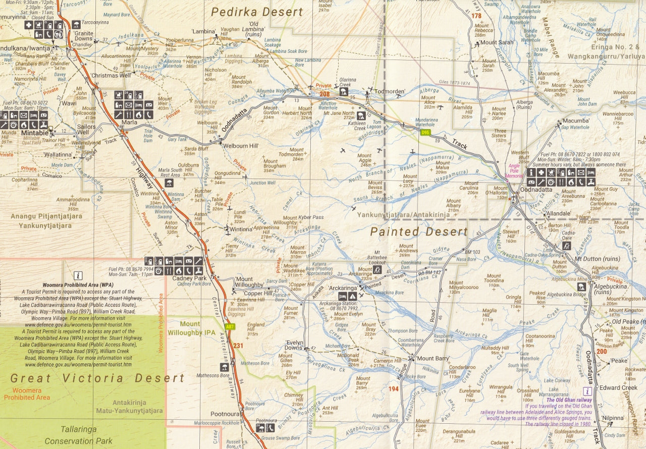
Side A – Simpson Desert (Scale: 1:500,000)
-
Offers highly detailed cartography ideal for real-time navigation across the desert.
-
Includes major desert crossings, track conditions, and topographical detail.
-
-
Side B – Regional Overview (Scale: 1:1,000,000)
-
Perfect for plotting your route into and out of the desert.
-
Useful for understanding regional connections and supply points.
-
Key routes featured:
-
French Line
-
WAA Line
-
Rig Road
-
QAA Line
-
K1 Line
-
Warburton Track
-
Madigan Line
-
Hay River Track
-
And more connecting routes between South Australia, Northern Territory, and Queensland
🛠️ Essential Features for Remote Travel
-
24-hour fuel availability
-
Camping and bush campsites
-
Water points and supply locations
-
National Park boundaries (including Witjira & Simpson Desert Conservation Park)
-
Track classifications (4WD only, formed, unformed, sandy)
-
Distance markers, contour shading, and dune line indicators
-
Points of interest: historical markers, ruins, landmarks, Indigenous heritage sites
-
Permit zones clearly marked with access information
-
Topographic shading for elevation and landform interpretation
Everything is laid out with Hema’s hallmark clarity and rugged reliability — you can trust this map whether you’re crossing the Simpson west to east, making a Madigan Line traverse, or linking tracks through Birdsville, Dalhousie Springs, Mt Dare, and Old Andado.
🌧️ Designed for Harsh Conditions
-
Material: Waterproof and tear-resistant synthetic paper
-
Built to withstand heat, dust, and rough handling
-
Easy to fold and store in map pockets, centre consoles, or backpacks
-
Resistant to rain and can be written on with dry-erase markers or grease pencils
📐 Product Details
-
Edition: 9th Edition
-
Release Date: June 2022
-
Map Size (unfolded): 700 mm × 1000 mm
-
Folded Size: 140 mm × 250 mm × 6 mm
-
Weight: ~55 grams
-
Printed in: Australia
-
Publisher: Hema Maps
🎯 Perfect For
-
4WD adventurers tackling desert crossings
-
Outback tour operators and overland guides
-
Bushwalkers and researchers studying arid ecology or desert geography
-
Photographers and storytellers capturing the red heart of Australia
-
Simpson Desert Challenge and Finke Desert Race followers
-
Anyone using the Great Desert Tracks Map Pack who needs a dedicated Simpson focus
🔁 Pair With
For full desert coverage, the Hema Great Desert Tracks Map Pack includes:
-
Western Sheet
Together, they form the most complete and trusted desert mapping resource available in Australia.
✍️ Final Word
The Simpson Desert remains one of the last true remote frontiers — beautiful, brutal, and unforgettable. This Hema map combines rugged durability, precise GPS tracking, and practical bush-ready design, giving you the confidence to go deeper, further, and safer.
Plan thoroughly. Travel responsibly. Explore boldly.
With the Hema Simpson Desert Map, you’re holding more than just a navigation aid — you’re holding the key to one of Australia’s greatest outback adventures.


