- Australia ▾
- Topographic
▾
- Australia AUSTopo 250k (2025)
- Australia 50k Geoscience maps
- Australia 100k Geoscience maps
- Australia 250k Geoscience maps
- Australia 1:1m Geoscience maps
- New Zealand 50k maps
- New Zealand 250k maps
- New South Wales 25k maps
- New South Wales 50k maps
- New South Wales 100k maps
- Queensland 10k maps
- Queensland 25k maps
- Queensland 50k maps
- Queensland 100k maps
- Western Australia 25k maps
- Western Australia 50k maps
- Western Australia 100k maps
- Compasses
- Software
- GPS Systems
- International ▾
- Wall Maps
▾
- World
- Australia & New Zealand
- Countries, Continents & Regions
- Historical
- Vintage National Geographic
- Australian Capital Territory
- New South Wales
- Northern Territory
- Queensland
- South Australia
- Tasmania
- Victoria
- Western Australia
- Celestial
- Children's
- Mining & Resources
- Wine Maps
- Healthcare
- Postcode Maps
- Electoral Maps
- Nautical ▾
- Flags
▾
- Australian Flag Sets & Banners
- Flag Bunting
- Handwavers
- Australian National Flags
- Aboriginal Flags
- Torres Strait Islander Flags
- International Flags
- Flagpoles & Accessories
- Australian Capital Territory Flags
- New South Wales Flags
- Northern Territory Flags
- Queensland Flags
- South Australia Flags
- Tasmania Flags
- Victoria Flags
- Western Australia Flags
- Gifts ▾
- Globes ▾
Dear valued customer. Please note that our checkout is not supported by old browsers. Please use a recent browser to access all checkout capabilities


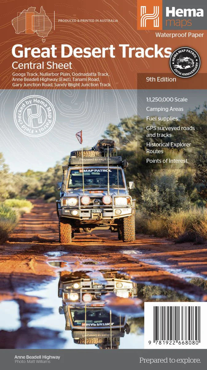
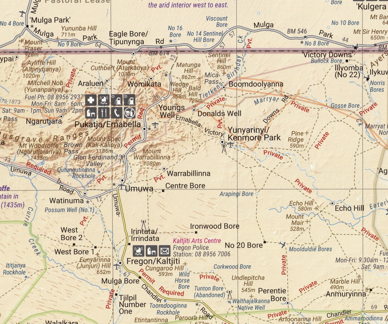
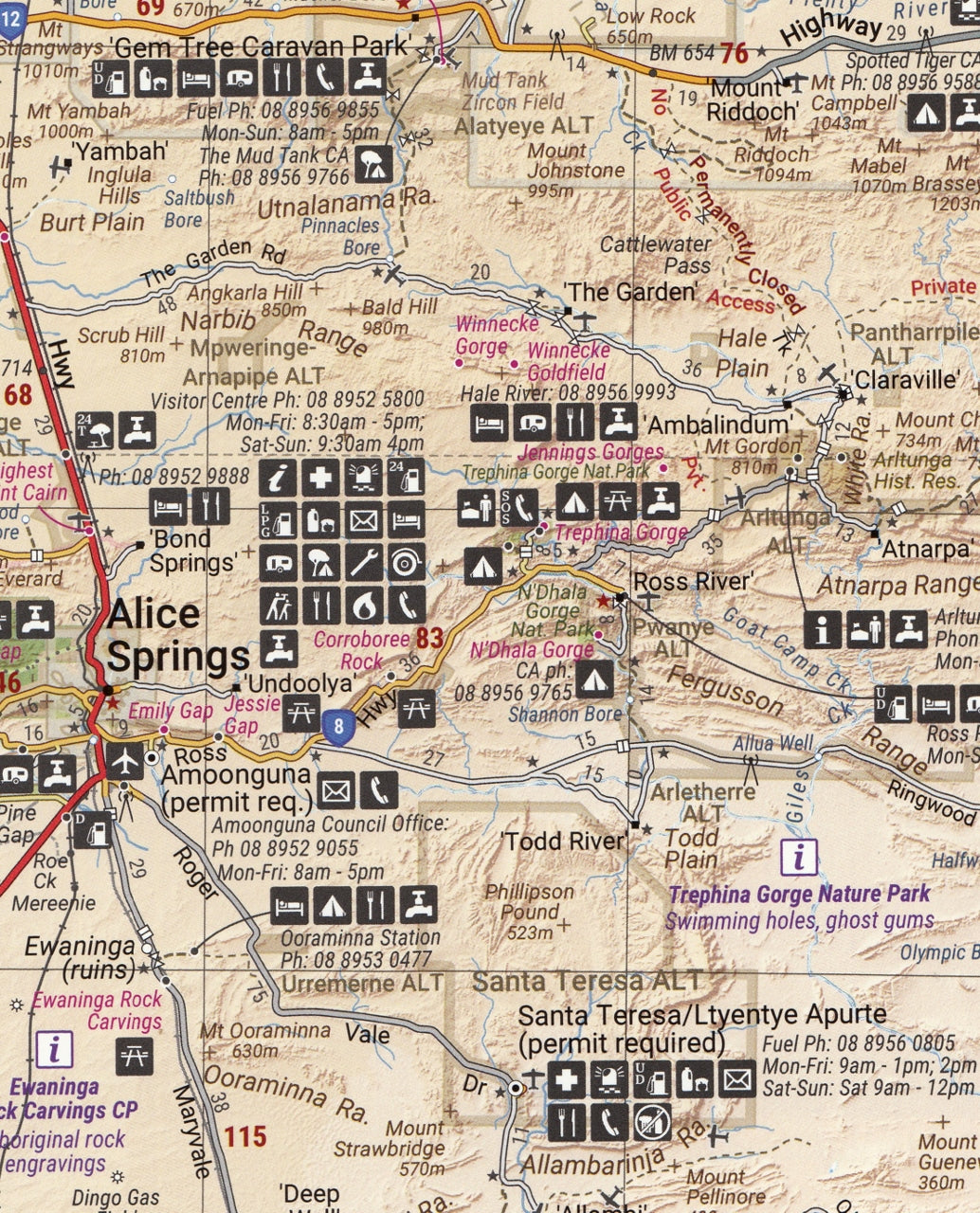
Great Desert Tracks Central Sheet Hema Map
$14.95
Afterpay is only available for orders between $50.00 and $1000.00 More info
Australia’s Most Trusted Map for Exploring the Red Centre
📍 Laminated & Waterproof Option Available
🌵 Your Essential Companion Through the Heart of the Outback
For those who dare to go beyond the bitumen, the Great Desert Tracks Central Sheet by Hema Maps is your ultimate navigation tool for Australia’s vast and untamed interior. Covering the remote tracks, Aboriginal lands, arid ranges, and iconic 4WD routes of central Australia, this map is more than just a chart—it’s a survival essential for every serious overland traveller, grey nomad, off-grid camper, and outback enthusiast.
Researched and field-checked by the Hema Map Patrol, the 9th edition offers unparalleled accuracy, rugged dependability, and a level of detail trusted by Australia's most experienced explorers.
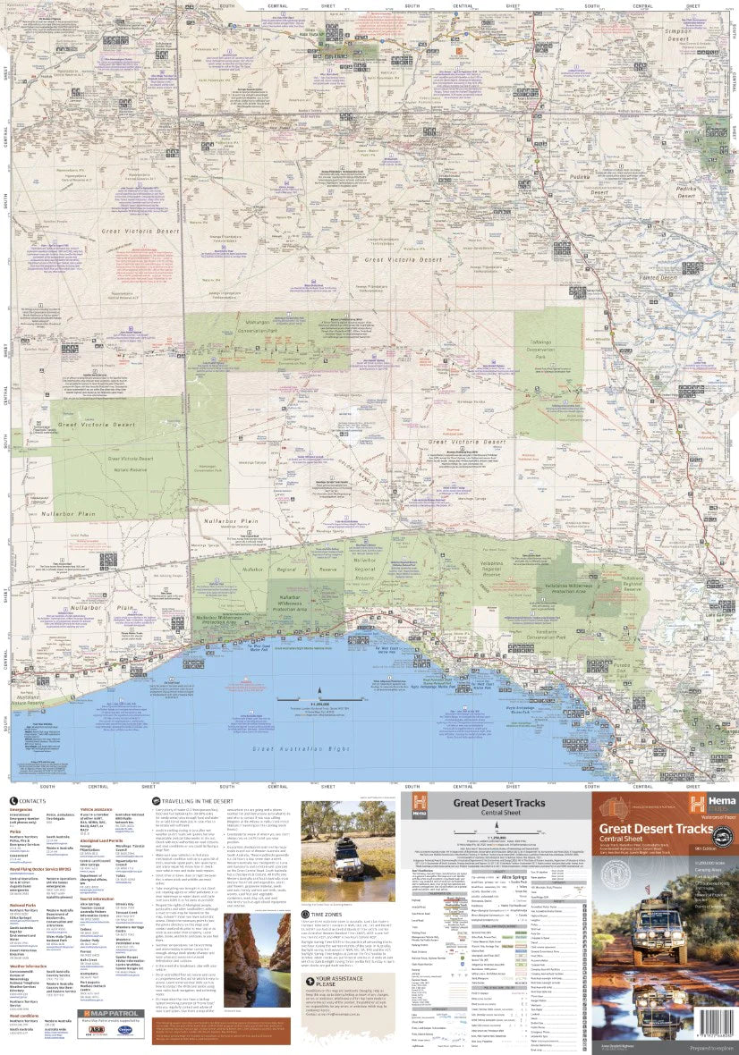
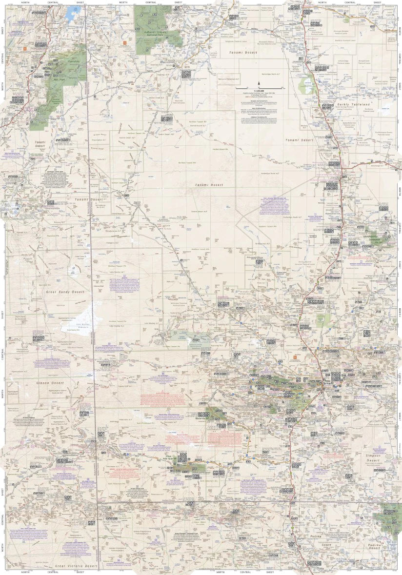
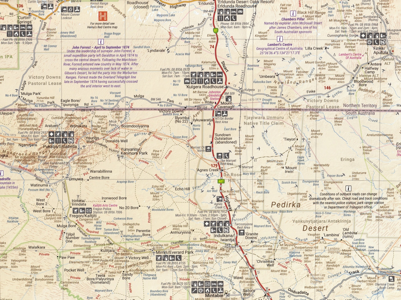
🗺️ Map Coverage – Where Adventure Begins
This sheet spans an expansive central corridor of the continent, taking in sections of:
-
Northern Territory: from Judbarra/Gregory National Park, through the Tanami
-
South Australia: including Coober Pedy, the Oodnadatta Track, and Ceduna
-
Western Australia: up to Halls Creek, brushing the edge of the Kimberley
Explore legendary outback routes including:
-
🛻 Googs Track
-
🛻 Nullarbor Plain Crossing
-
🛻 Oodnadatta Track
-
🛻 Anne Beadell Highway (Eastern Section)
-
🛻 Tanami Road
-
🛻 Gary Junction Road
-
🛻 Sandy Blight Junction Track
-
🛻 WAA Line (Eastern edge)
-
🛻 Great Central Road (partial coverage)
Ideal for planning trips across the Great Victoria, Gibson, Great Sandy, Tanami, and Simpson Desert fringes.
🧭 Key Features
| Feature | Details |
|---|---|
| Scale | 1:1,250,000 – perfect for navigation across remote expanses |
| Topographic Relief | Elevation shading and contours to visualise terrain & dunes |
| 4WD Tracks | Colour-coded for condition, surface, and accessibility |
| Campsites | Bush camping, national park campgrounds, rest stops |
| Fuel Stops | Locations, fuel types, 24-hour stations, and distance markers |
| Points of Interest | Landmarks, outback towns, roadhouses, waterholes |
| Travel Tips | Permit areas, safety guidance, communication tips |
| GPS Compatible | Grid references & compatible with Hema Explorer / HX-2 |
| Emergency Contacts | Quick-reference regional numbers for help when it matters |
🧳 Who Is This Map For?
-
🚐 4WD Adventurers
-
🏕️ Bush Campers & Grey Nomads
-
🌄 Outback Photographers & Filmmakers
-
🛻 Overland Explorers
-
🧭 Motorbike Tourers
-
🧰 Survival Planners & Expedition Coordinators
Whether you're crossing the Gibson, tracking dunes in the Simpson, or tackling fuel range across the Anne Beadell, this is the map to get you there—and back—safely.
📚 Desert Travel Know-How Included
On the reverse side, find an invaluable desert survival panel with expert guidance on:
-
What to pack for remote desert driving
-
Fuel range planning
-
Communication equipment
-
Emergency procedures
-
Indigenous land permit zones & respectful travel practices
This information could save time, protect your vehicle, or in extreme cases—save your life.
📏 Map Specifications
| Specification | Details |
|---|---|
| Edition | 9th Edition |
| Publication Date | June 2022 |
| Unfolded Size | 1000 mm × 700 mm |
| Folded Size | 140 mm × 250 mm × 6 mm |
| Weight | 55 grams |
| Format | Single-sided synthetic waterproof & tear-resistant paper |
| ISBN | 9781865009452 |
🛠️ Optional Upgrade: Laminated Version
Prefer something more durable? We offer a laminated version, encapsulated between two layers of premium 80-micron gloss laminate—making it:
-
✅ Dry-erasable (for use with whiteboard markers)
-
✅ Durable – resistant to tearing, spills, and harsh weather
-
✅ Perfect for map dots, pins, and trip tracking
Just roll it up and go—ideal for campers, 4WDers, and long-haul travellers.
🗺️ Expand Your Collection
This map is part of the Great Desert Tracks series:
-
Eastern Sheet – Birdsville, Innamincka, Simpson Desert
-
Western Sheet – Gunbarrel Highway, Connie Sue Highway
-
Simpson Desert Sheet – High-detail coverage of the Simpson
-
Complete Map Pack – All four maps in a rugged folder
🏕️ Summary
The Hema Great Desert Tracks Central Sheet is not just a map—it's a mission companion, a route planner, a lifeline in the wild, and a trusted guide through one of the world’s last great frontiers.
If you're heading into the centre of Australia with a 4WD and a thirst for real adventure, this is the map you'll want by your side.
📦 Add it to your expedition kit today—and journey into the red heart of Australia with confidence.
Frequently Asked Questions
What does the Great Desert Tracks Central Sheet Hema Map cover?
The Great Desert Tracks Central Sheet Hema Map covers 4WD tracks, camping areas, and travel routes for the region described in the product title. Most 4WD and camping guides in Mapworld's range include GPS coordinates, distance information, difficulty ratings, and notes on fuel stops and emergency contact points.
Is the Great Desert Tracks Central Sheet Hema Map up to date?
Yes, this is the current edition. Mapworld stocks current editions from publishers including Hema Maps, Westprint, and others.
Is this product suitable for remote area travel?
Yes, 4WD maps and guides are designed for remote area navigation and trip planning. They include track conditions, fuel availability, camping spots, and safety information.
Does Mapworld ship the Great Desert Tracks Central Sheet Hema Map across Australia?
Yes, Mapworld ships Australia-wide. Standard shipping is a flat $7 rate, with free standard shipping on orders over $75. Express options are available at checkout. Most orders placed before 2pm AEST on weekdays are dispatched same day.
Related Items


© 2026 Mapworld. Website designed by Genie Media
X