

A practical and visually impressive cartographic reference for work, study, or home — combining state-wide overview with detailed urban clarity
This updated 2024 edition of UBD Gregory’s Victoria State & Suburban Map delivers the best of both worlds in a double-sided laminated wall map. One side offers a clear, indexed view of the entire state of Victoria, while the reverse zooms in on Melbourne’s suburban expanse, giving you unmatched insight into how the city and region interconnect.
Perfect for strategic planners, educators, businesses, real estate agents, or geography lovers, this map is a versatile, easy-to-read reference tool that works beautifully as both an interactive planner and an elegant wall display.
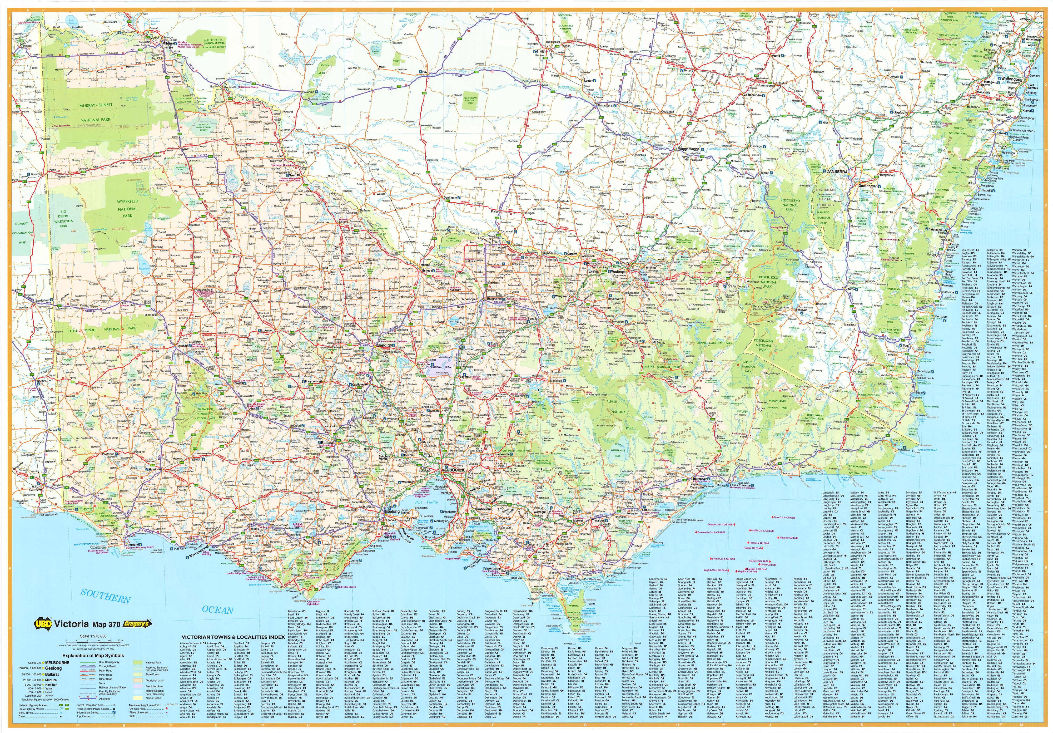
🧭 Side One – Victoria State Map
Scale: 1:975,000
Covering all of Victoria, this state-wide map is designed to support everything from road trip planning and logistical routing to classroom instruction and territory mapping. Key features include:
-
Clear depiction of major highways, minor roads, and sealed/unsealed routes
-
National highways and dual carriageways marked for easier navigation
-
All regional towns, cities, and localities indexed and labelled
-
National parks, conservation areas, and nature reserves highlighted for outdoor enthusiasts or environmental planning
-
Useful for seeing Victoria in context — from border towns like Mildura and Wodonga to remote regional hubs such as Mallacoota or Warrnambool
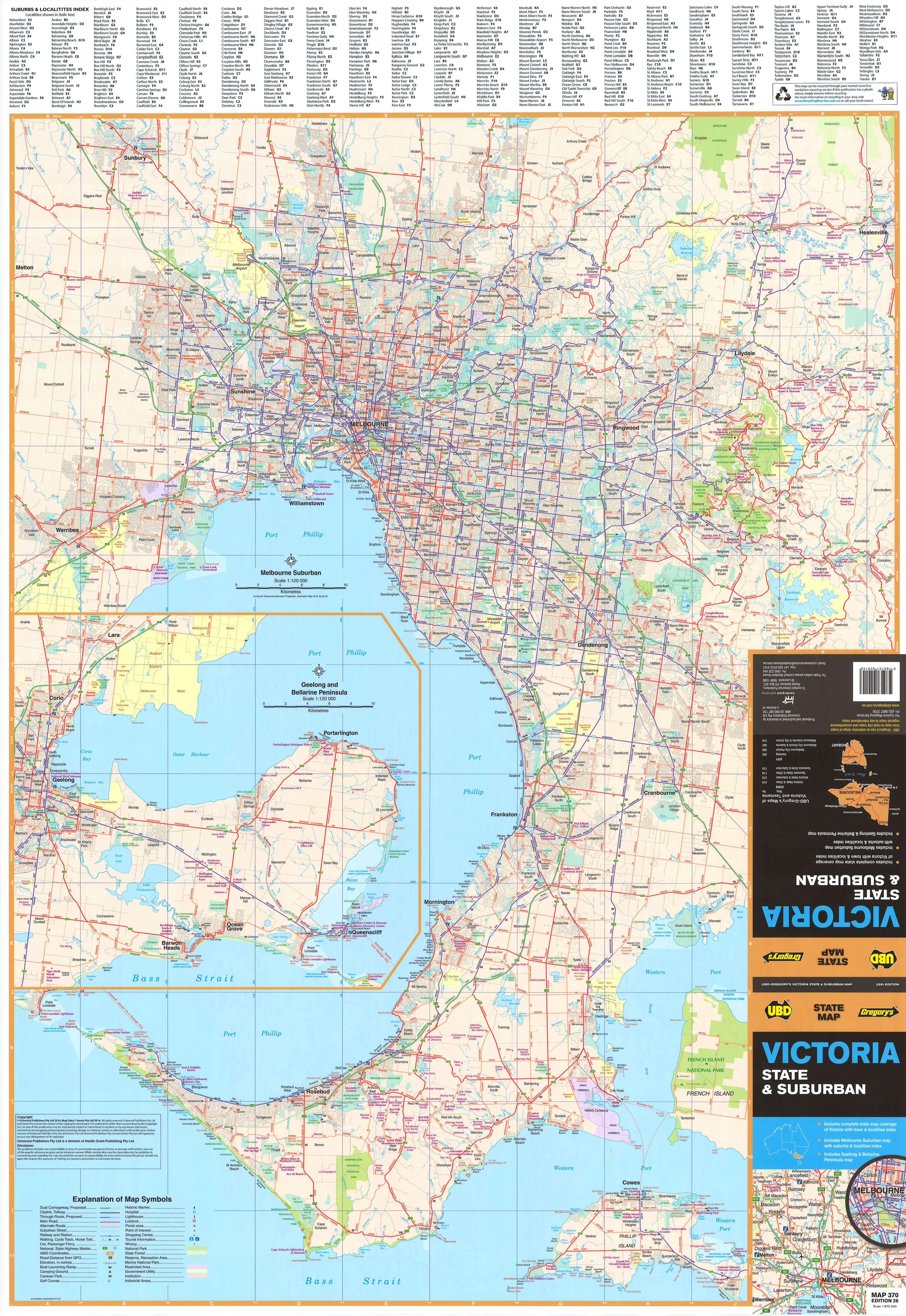
🌆 Side Two – Greater Melbourne Suburban Map
Scale: 1:120,000
This detailed metropolitan map captures the full scope of Melbourne’s suburban sprawl, providing an invaluable tool for residents, professionals, and planners alike. It covers a 75 km radius from Melbourne’s CBD, extending:
-
North to Sunbury
-
South to Cowes and Phillip Island
-
West to Bacchus Marsh, and east to the Dandenong Ranges
-
Includes a handy inset map of Geelong and the Bellarine Peninsula
Key features:
-
Clearly marked arterial roads, motorways, ring roads, and main connections
-
Suburb names and boundaries clearly defined, each labelled with their postcode
-
Industrial areas, commercial zones, and green belts differentiated for visual clarity
-
National parks, waterways, and regional infrastructure like airports, ports, and transport hubs also shown
-
Comprehensive suburb index to easily locate specific areas
This side of the map is particularly useful for property market research, local government planning, network service mapping, and commuter route assessment.
📐 Map Specifications:
-
Size: 1000 mm (W) x 690 mm (H) – a substantial format without overwhelming your wall
-
Double-Sided: Two maps in one – Victoria state overview + Greater Melbourne detail
-
Scales:
-
Victoria State Map – 1:975,000
-
Greater Melbourne – 1:120,000
-
-
Edition: 2024
-
Publisher: UBD Gregory’s – Australia’s most respected street map publisher
🧽 Durable Lamination & Interactive Features
Each map is encapsulated in high-quality 80-micron gloss laminate, making it:
-
Water-resistant and tear-proof – ideal for high-use areas like offices, classrooms, and workshops
-
Compatible with whiteboard markers – great for route planning, meetings, or educational purposes
-
Works with map dots or stickers – perfect for sales mapping, territory definition, or tracking travel history
-
Easy to wipe clean, allowing repeated use without degrading quality
🪵 Optional Timber Hanging Rails
For easy wall display and a refined finish, we offer wooden hang rollers:
-
Fitted to the top and bottom of the map
-
Natural timber finish, lacquered for durability and aesthetic appeal
-
Comes with a hanging cord attached to the top rail — simply place on a hook or nail
-
Please allow up to 10 working days for delivery of hang-railed maps, as they are custom-prepared by our framer
💰 Laminated Options & Pricing
-
Flat Laminated Map – $99.00
-
Delivered flat and ready for immediate wall display or framing
-
Preferred option for presentation environments, boardrooms, classrooms, and public areas
-
-
Laminated Folded Map – $49.95
-
Produced by laminating a previously folded map — slight crease lines may be visible
-
Fully functional, budget-friendly alternative for personal or back-office use
-
🎯 Who This Map Is For:
-
Real estate professionals – Define market areas, client suburbs, or development zones
-
Planners and developers – Reference growth corridors, infrastructure, and zoning regions
-
Teachers and students – A helpful resource for geography, civics, and environment education
-
Businesses and logistics teams – Plan delivery areas, sales routes, or regional expansion
-
Councils and government agencies – Perfect for community planning and transport analysis
-
Families and individuals – Great for house hunting or simply understanding Melbourne’s layout
🏆 Why Choose This Map?
-
Created by UBD Gregory’s, Australia’s trusted authority on street-level mapping
-
Combines broad regional perspective with detailed urban navigation
-
Fully indexed, interactive, and easy to read
-
Durable and stylish — suitable for display or functional planning
-
Australian-made and published, supporting local cartography and quality standards
Plan, explore, educate, or display — with UBD Gregory’s Victoria State & Greater Melbourne Suburban Map, you’ll have all of Victoria in view and Melbourne at your fingertips.
