- Australia ▾
- Topographic
▾
- Australia AUSTopo 250k (2025)
- Australia 50k Geoscience maps
- Australia 100k Geoscience maps
- Australia 250k Geoscience maps
- Australia 1.1m Geoscience maps
- New Zealand 50k maps
- New Zealand 250k maps
- New South Wales 25k maps
- New South Wales 50k maps
- New South Wales 100k maps
- Queensland 10k maps
- Queensland 25k maps
- Queensland 50k maps
- Queensland 100k maps
- Compasses
- Software
- GPS Systems
- Orienteering
- International ▾
- Wall Maps
▾
- World
- Australia & New Zealand
- Countries, Continents & Regions
- Historical
- Vintage National Geographic
- Australian Capital Territory
- New South Wales
- Northern Territory
- Queensland
- South Australia
- Tasmania
- Victoria
- Western Australia
- Celestial
- Children's
- Mining & Resources
- Wine Maps
- Healthcare
- Postcode Maps
- Electoral Maps
- Nautical ▾
- Flags
▾
- Australian Flag Sets & Banners
- Flag Bunting
- Handwavers
- Australian National Flags
- Aboriginal Flags
- Torres Strait Islander Flags
- International Flags
- Flagpoles & Accessories
- Australian Capital Territory Flags
- New South Wales Flags
- Northern Territory Flags
- Queensland Flags
- South Australia Flags
- Tasmania Flags
- Victoria Flags
- Western Australia Flags
- Gifts ▾
- Globes ▾
Dear valued customer. Please note that our checkout is not supported by old browsers. Please use a recent browser to access all checkout capabilities
Melbourne UBD 362 Map 1020 x 1480mm Laminated Wall Map
$365.00
or make 4 interest-free payments of
$91.25 AUD
fortnightly with
![]() More info
More info
Laminated | 1020 mm (W) x 1480 mm (H)
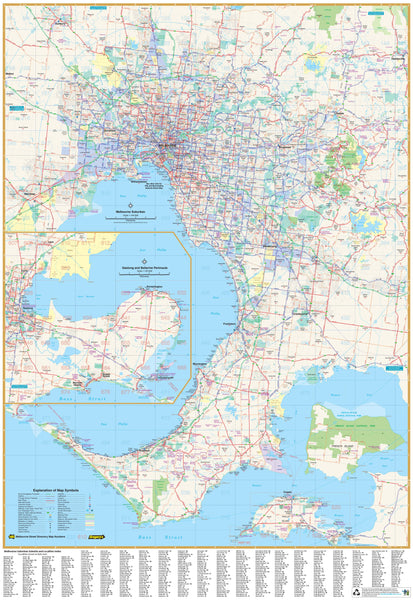
A highly detailed and professionally produced wall map by UBD Gregory’s, this map offers a comprehensive view of Melbourne and its surrounding suburbs within a 75-kilometre radius. Ideal for both home and office use, this map is perfect for strategic planning, logistics, education, or simply understanding the broader layout of the city.
Extensive Suburban Coverage
Covering from Sunbury in the north to Cowes in the south, and including a detailed inset of Geelong and the Bellarine Peninsula, this map offers an exceptional overview of:
-
Major and minor arterial roads and transport routes
-
Suburban built-up areas and infrastructure
-
Clearly delineated national parks and industrial zones
-
Every suburb labelled with corresponding postcode numbers
An extensive indexed suburb list makes navigation and reference fast and intuitive.
Laminated for Practical Use
The map is fully encapsulated in 80-micron gloss laminate, making it:
-
Durable – resistant to tears, stains, and wear
-
Writable & Wipeable – use with whiteboard markers for temporary notes or planning
-
Map Dot-Friendly – ideal for marking locations without damaging the surface
Perfect for wall-mounted use in shared or working environments.
📐 Specifications
| Feature | Details |
|---|---|
| Map Title | Melbourne 75km Suburban Radius Map |
| Publisher | UBD Gregory’s |
| Inset | Geelong & Bellarine Peninsula |
| Indexed | Yes – Suburbs with Postcodes |
| Format | Flat, Laminated Wall Map |
| Size | 1020 mm (W) × 1480 mm (H) |
| Finish | Gloss Laminate |
| Made in | Australia |
Use Cases
-
Real estate offices
-
Distribution & delivery planning
-
Government departments
-
Classrooms & libraries
-
Home studies or garage walls
Whether you're mapping out delivery zones, tracking suburban growth, or simply want a stunning visual reference for Melbourne, this Melbourne Suburban Wall Map by UBD Gregory’s is a practical and stylish solution for every space.


