- Australia ▾
- Topographic
▾
- Australia AUSTopo 250k (2025)
- Australia 50k Geoscience maps
- Australia 100k Geoscience maps
- Australia 250k Geoscience maps
- Australia 1.1m Geoscience maps
- New Zealand 50k maps
- New Zealand 250k maps
- New South Wales 25k maps
- New South Wales 50k maps
- New South Wales 100k maps
- Queensland 10k maps
- Queensland 25k maps
- Queensland 50k maps
- Queensland 100k maps
- Compasses
- Software
- GPS Systems
- Orienteering
- International ▾
- Wall Maps
▾
- World
- Australia & New Zealand
- Countries, Continents & Regions
- Historical
- Vintage National Geographic
- Australian Capital Territory
- New South Wales
- Northern Territory
- Queensland
- South Australia
- Tasmania
- Victoria
- Western Australia
- Celestial
- Children's
- Mining & Resources
- Wine Maps
- Healthcare
- Postcode Maps
- Electoral Maps
- Nautical ▾
- Flags
▾
- Australian Flag Sets & Banners
- Flag Bunting
- Handwavers
- Australian National Flags
- Aboriginal Flags
- Torres Strait Islander Flags
- International Flags
- Flagpoles & Accessories
- Australian Capital Territory Flags
- New South Wales Flags
- Northern Territory Flags
- Queensland Flags
- South Australia Flags
- Tasmania Flags
- Victoria Flags
- Western Australia Flags
- Gifts ▾
- Globes ▾
Dear valued customer. Please note that our checkout is not supported by old browsers. Please use a recent browser to access all checkout capabilities
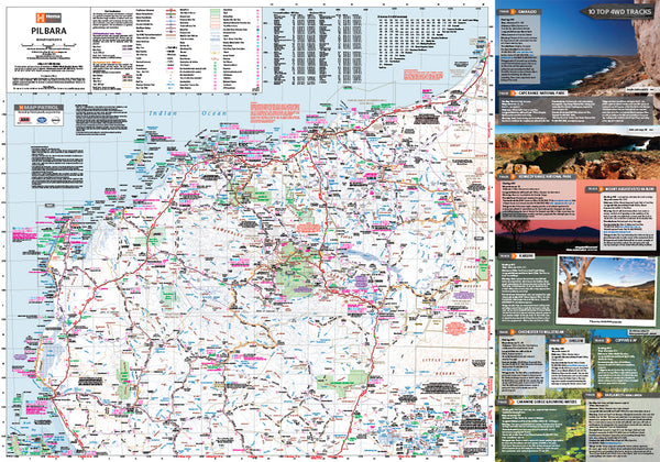
Pilbara & Coral Coast Hema 700 x 1000mm Map Laminated Wall Map
$45.00
Afterpay is only available for orders between $50.00 and $1000.00 More info
Scale: 1:1,250,000 | Size: 700 mm (W) x 1000 mm (H)
Field-checked. Rugged. Ready for the outback.
🚙 Your Essential Guide to Australia’s Remote Northwest
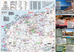
The Pilbara & Coral Coast Wall Map by Hema is an expertly crafted map designed for serious adventurers, 4WD explorers, and lovers of Australia’s wild northwest. Spanning one of the country’s most remote and captivating regions, this map covers the dramatic landscapes of the Pilbara, the spectacular reefs of the Ningaloo Coast, and the rich red heart of outback WA.
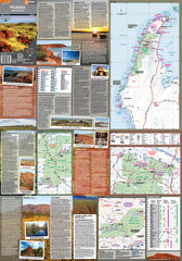
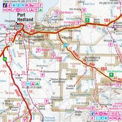
Extensively field-checked using Hema’s GPS mapping technology, it includes roads and off-road tracks that have never previously appeared on published maps. Combined with detailed inset maps and extensive travel information, this is more than a map—it’s your essential planning companion.
🧭 Map Features & Highlights
| 🌟 Feature | ✅ Benefit |
|---|---|
| GPS-Surveyed Roads & Tracks | Includes new and updated 4WD routes and remote access roads |
| Inset Maps | Regional zooms for high-interest areas |
| Fuel Supply Markers | Easily locate refuelling points in remote areas |
| Camping Areas | Overnight stops, national parks, and recreational campsites clearly marked |
| Tourist & Safety Info | Local highlights, what to see, what to avoid, and survival tips |
| National Parks | Boundaries, access tracks and major natural attractions labelled |
📍 Regions Covered
-
Karijini National Park
-
Millstream-Chichester National Park
-
Exmouth & Ningaloo Reef
-
Port Hedland, Karratha & Onslow
-
Coral Bay to Carnarvon
-
Gascoyne Hinterlands
-
Remote pastoral stations, reserves, and outback tracks
🛡️ Professional Laminate Finish
Encapsulated in high-quality 80-micron gloss laminate, this map is:
-
🖊️ Writeable with whiteboard markers
-
💦 Water and stain resistant
-
💪 Tear-resistant and made to last
-
📌 Perfect for wall display, trip planning, or tracking your journey
Please note: This map has been flattened and laminated from a folded version, so minor fold lines may still be visible.
📐 Product Details
| Specification | Description |
|---|---|
| Map Title | Pilbara & Coral Coast – Hema Maps |
| Scale | 1:1,250,000 |
| Size | 700 mm (W) x 1000 mm (H) |
| Finish | Gloss Laminated (encapsulated) |
| Edition | Latest available |
| Publisher | Hema Maps |
| Format | Flat, laminated wall map |
🧭 Perfect For:
-
🛻 4WD adventurers and off-grid travellers
-
🏕️ Camping and caravanning the Coral Coast
-
🏫 Educators and geography lovers
-
🏢 Offices, travel centres, and mine sites
-
🎁 A unique and practical gift for outback explorers
From gorges to ghost towns, reefs to red dirt—discover the true north of Western Australia with a map built for the road less travelled.


