- Australia ▾
- Topographic
▾
- Australia AUSTopo 250k (2024)
- Australia 50k Geoscience maps
- Australia 100k Geoscience maps
- Australia 250k Geoscience maps
- Australia 1.1m Geoscience maps
- New Zealand 50k maps
- New Zealand 250k maps
- New South Wales 25k maps
- New South Wales 50k maps
- New South Wales 100k maps
- Queensland 10k maps
- Queensland 25k maps
- Queensland 50k maps
- Queensland 100k maps
- Compasses
- Software
- GPS Systems
- Orienteering
- International ▾
- Wall Maps
▾
- World
- Australia & New Zealand
- Countries, Continents & Regions
- Historical
- Vintage National Geographic
- Australian Capital Territory
- New South Wales
- Northern Territory
- Queensland
- South Australia
- Tasmania
- Victoria
- Western Australia
- Celestial
- Children's
- Mining & Resources
- Wine Maps
- Healthcare
- Postcode Maps
- Electoral Maps
- Nautical ▾
- Flags
▾
- Australian Flag Sets & Banners
- Flag Bunting
- Handwavers
- Australian National Flags
- Aboriginal Flags
- Torres Strait Islander Flags
- International Flags
- Flagpoles & Accessories
- Australian Capital Territory Flags
- New South Wales Flags
- Northern Territory Flags
- Queensland Flags
- South Australia Flags
- Tasmania Flags
- Victoria Flags
- Western Australia Flags
- Gifts ▾
- Globes ▾
Dear valued customer. Please note that our checkout is not supported by old browsers. Please use a recent browser to access all checkout capabilities


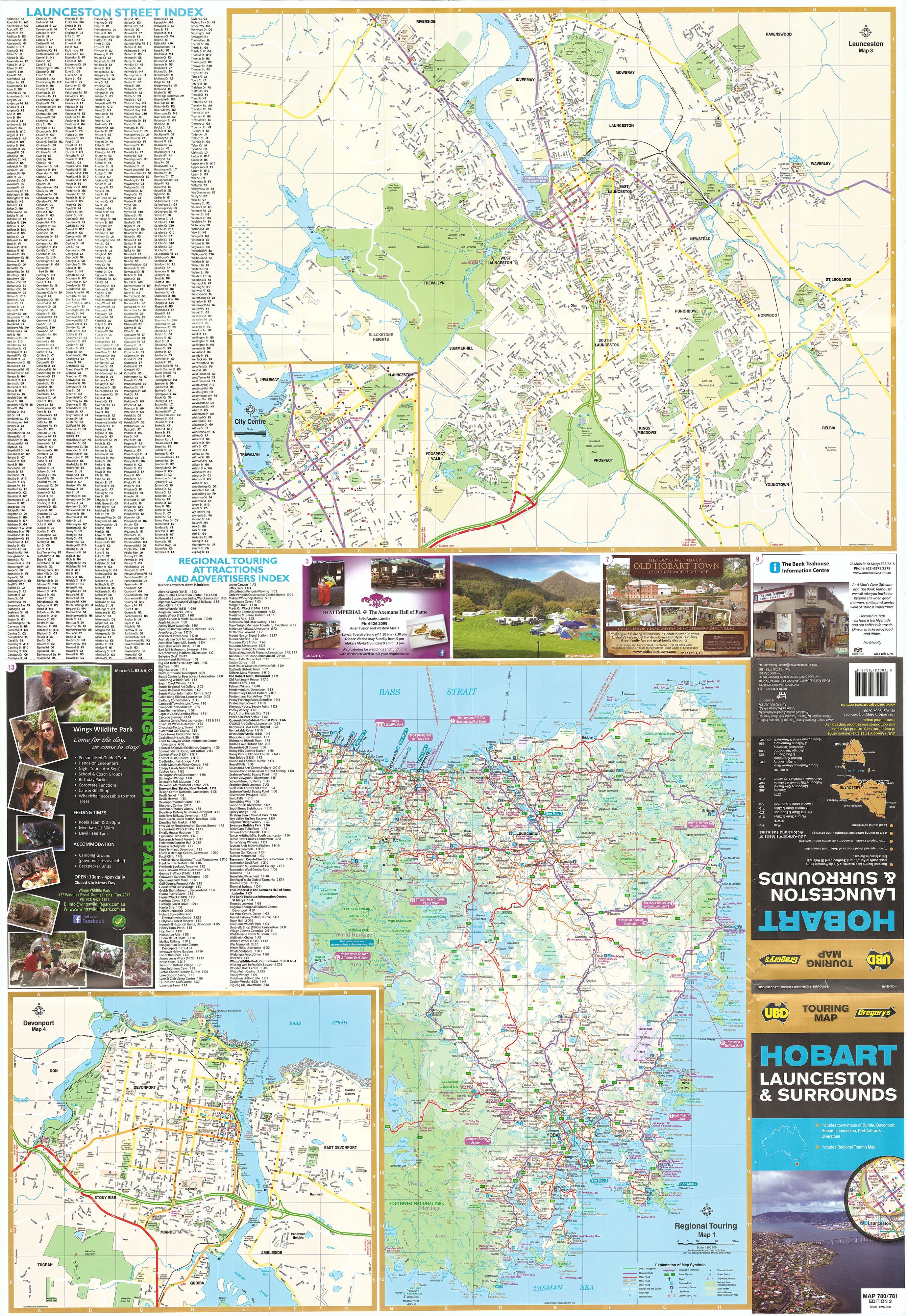
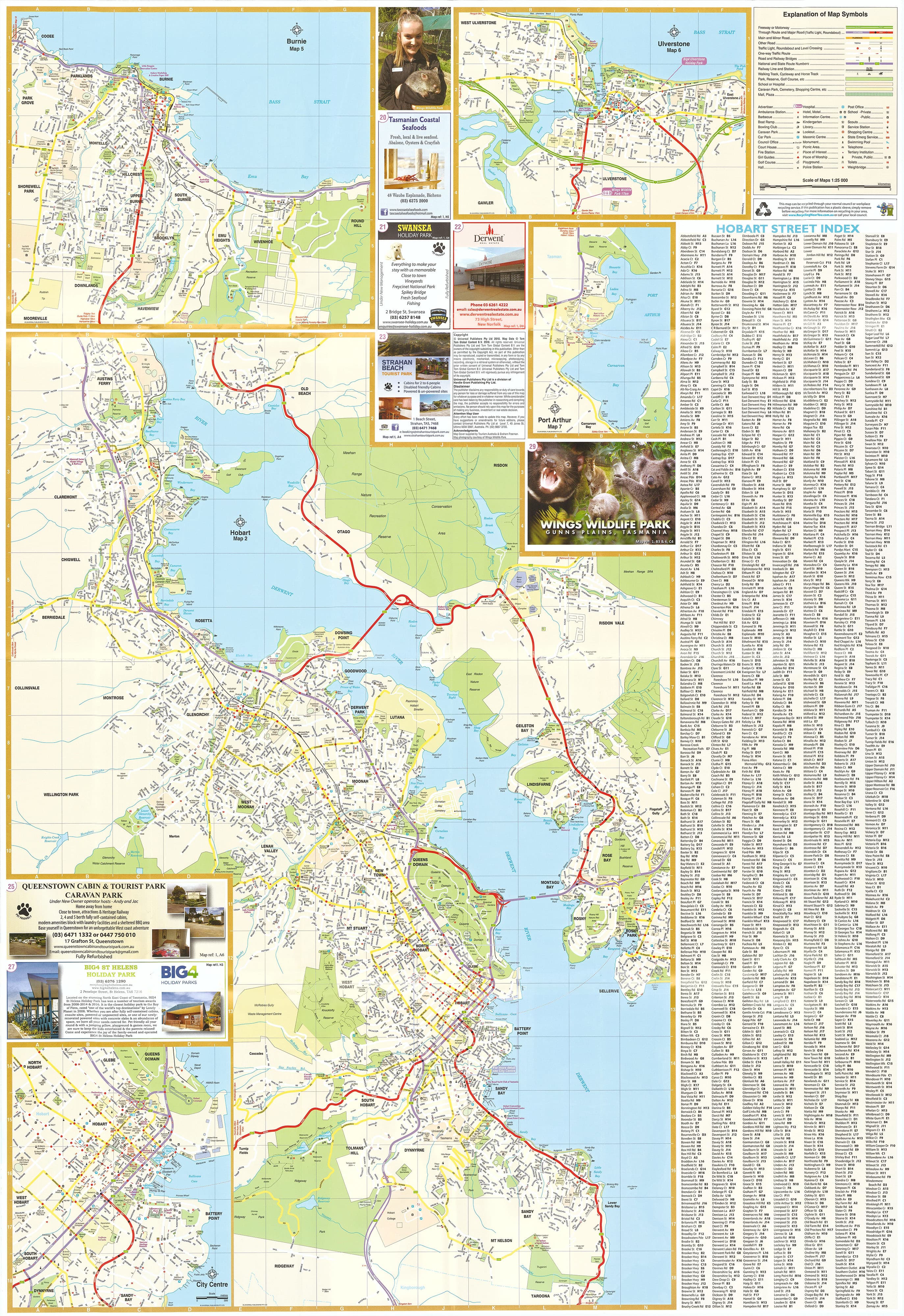
Hobart, SE Tasmania & Launceston UBD Map 780/781
$49.95
Afterpay is only available for orders between $50.00 and $1000.00 More info
Explore Tasmania’s Heart with Confidence
Tasmania’s charm lies in its contrasts—heritage towns and untamed wilderness, alpine lakes and coastal bays, local markets and world-class eateries. This Touring Map by UBD Gregory's provides an essential companion to help you navigate it all.
Whether you’re road-tripping from Launceston to Hobart, tracing convict history along the east coast, or planning day trips into Tasmania’s scenic hinterland, this map delivers all the accuracy and detail you need.
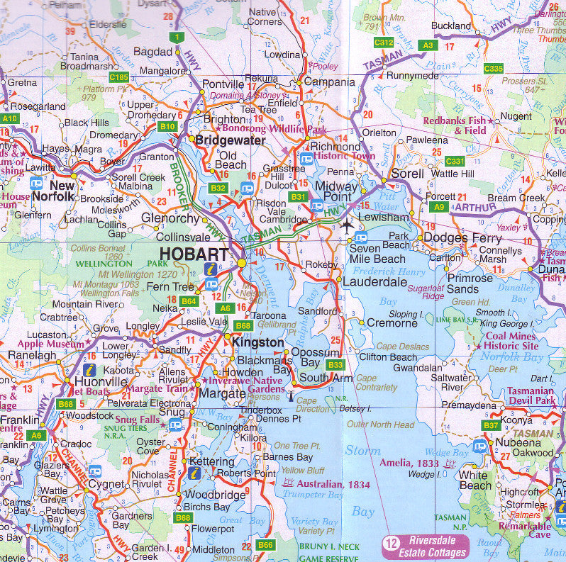
🗺️ Regional Map Coverage
This full-colour regional touring map features a meticulously charted overview of Tasmania’s southeast, making it ideal for both planning and real-time navigation.
Coverage extends:
-
South to South East Cape, the southernmost road-accessible point in Australia, perfect for wilderness lovers.
-
North to Wynyard, a charming coastal town near the tulip fields of Table Cape.
-
West to Nelsons Falls and the lush Franklin-Gordon Wild Rivers National Park.
-
East to Cornwall, on the edge of Tasmania’s scenic east coast.
Highlighted routes include the Heritage Highway, Midlands Highway, and key tourist trails like the Convict Trail and East Coast Escape.
🏙️ Town Maps Included
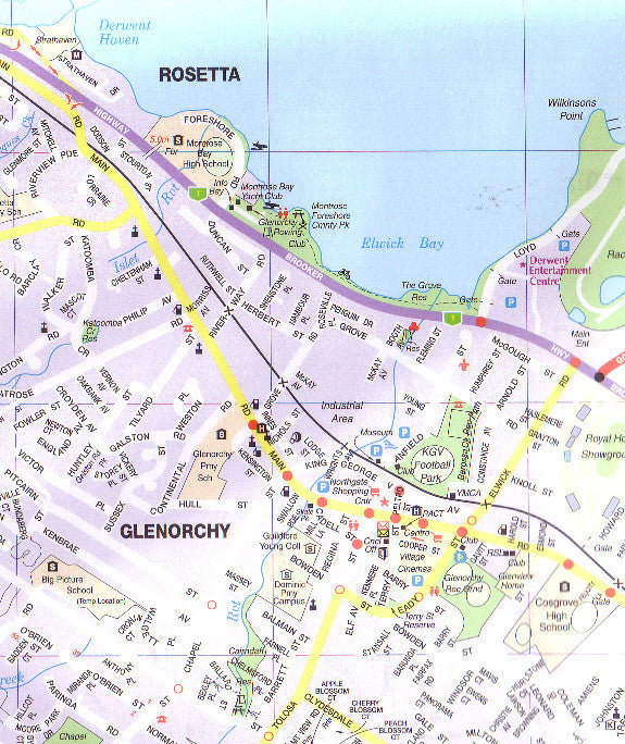
The map also features detailed inset town maps of Tasmania’s most visited and important towns:
-
Hobart – Navigate Tasmania’s capital, including Battery Point, Salamanca, MONA, and Mount Wellington.
-
Launceston – Coverage includes Cataract Gorge, the historic city centre, and surrounding suburbs.
-
Devonport – Vital for ferry travellers, including Spirit of Tasmania access points and road connections.
-
Burnie – Locate civic services, port infrastructure, and cultural attractions.
-
Ulverstone – A smaller town with local dining and arts.
-
Port Arthur – Essential detail for accessing the UNESCO-listed Port Arthur Historic Site and surrounding Peninsula highlights.
Each town map is indexed and includes major roads, facilities, parks, and points of interest.
📐 Product Details
| Feature | Detail |
|---|---|
| Scale | 1:25,000 – provides street-level clarity |
| Map Size (flat) | 700 mm (W) x 1000 mm (H) |
| Format | Folded paper OR laminated flat |
| Map Type | Regional & Town Inset Touring Map |
| Publisher | UBD Gregory’s |
| Lamination | 80-micron gloss (optional) |
| Indexing | Comprehensive town and road name index |
💧 Durable Laminated Option
Perfect for use in the field or repeated reference, the laminated version includes:
-
Encapsulation in premium 80-micron gloss laminate
-
Write-on/wipe-off surface compatible with whiteboard markers
-
Ideal for applying removable Map Dots to mark trip progress or favourite destinations
-
Enhanced resistance to water, dust, smudges, and wear
Please note: Laminated versions are produced by flattening a folded map before encapsulation. As a result, subtle fold lines may still be visible, though this does not affect legibility or performance.
🧳 Perfect for…
| User Type | Why It’s Ideal |
|---|---|
| Self-drive tourists | Plot scenic drives, overnight stays, and regional detours |
| Hikers & cyclists | Discover remote trails, rivers, and parkland regions |
| Tour planners | Provide clear overviews of destinations and access roads |
| Schools & educators | Use as a reference for geography or cultural studies |
| Home or office | Display as an informative and attractive wall feature |
📦 Delivery Information
-
Folded paper map ships flat in protective envelope
-
Laminated version shipped rolled in a durable mailing tube
-
Processing times: 1–2 business days
Start your Tasmanian adventure
Whether you’re buying for yourself, a loved one heading on a Tasmanian adventure, or a student discovering Australia’s geography, this Touring Map is a useful, educational, and inspiring tool. With over 1000 km of touring possibilities packed into one map, it’s time to start exploring the Apple Isle in detail.