- Australia ▾
- Topographic
▾
- Australia AUSTopo 250k (2025)
- Australia 50k Geoscience maps
- Australia 100k Geoscience maps
- Australia 250k Geoscience maps
- Australia 1:1m Geoscience maps
- New Zealand 50k maps
- New Zealand 250k maps
- New South Wales 25k maps
- New South Wales 50k maps
- New South Wales 100k maps
- Queensland 10k maps
- Queensland 25k maps
- Queensland 50k maps
- Queensland 100k maps
- Western Australia 25k maps
- Western Australia 50k maps
- Western Australia 100k maps
- Compasses
- Software
- GPS Systems
- International ▾
- Wall Maps
▾
- World
- Australia & New Zealand
- Countries, Continents & Regions
- Historical
- Vintage National Geographic
- Australian Capital Territory
- New South Wales
- Northern Territory
- Queensland
- South Australia
- Tasmania
- Victoria
- Western Australia
- Celestial
- Children's
- Mining & Resources
- Wine Maps
- Healthcare
- Postcode Maps
- Electoral Maps
- Nautical ▾
- Flags
▾
- Australian Flag Sets & Banners
- Flag Bunting
- Handwavers
- Australian National Flags
- Aboriginal Flags
- Torres Strait Islander Flags
- International Flags
- Flagpoles & Accessories
- Australian Capital Territory Flags
- New South Wales Flags
- Northern Territory Flags
- Queensland Flags
- South Australia Flags
- Tasmania Flags
- Victoria Flags
- Western Australia Flags
- Gifts ▾
- Globes ▾
Dear valued customer. Please note that our checkout is not supported by old browsers. Please use a recent browser to access all checkout capabilities


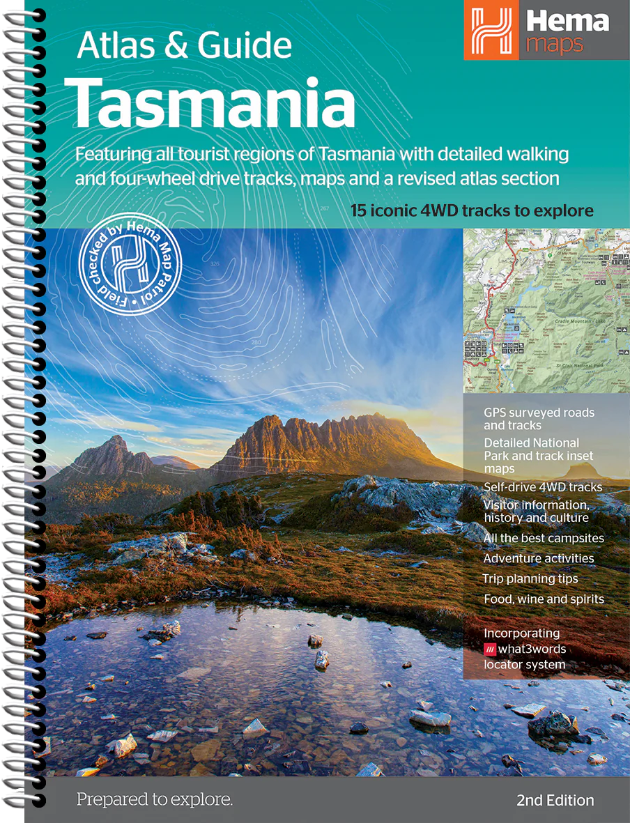
Tasmania Atlas & Guide Hema
$49.95
Afterpay is only available for orders between $50.00 and $1000.00 More info
The Ultimate Off-Road, Touring, and Walking Companion for Australia’s Island State
📖 40 Large-Format Atlas Pages | 🚙 15 Top 4WD Adventures | 🥾 5 Unmissable Walking Tracks | ⛺ Campsites, Activities & Travel Tips
Discover Tasmania Like Never Before
From the misty peaks of Cradle Mountain to the windswept coastlines of the Tarkine, Tasmania is a wilderness lover’s dream—and the Tasmania Atlas & Guide by Hema is your passport to unlocking its secrets.
This is far more than a map. It’s a hand-crafted adventure resource designed to take you deep into the heart of Tasmania’s national parks, mountain passes, historic villages, and remote camping zones. Combining detailed cartography, real on-the-ground data from Hema’s iconic Map Patrol, and practical trip-planning content, this 2nd edition is the definitive guide to touring Tasmania—on and off the bitumen.
What Makes This Atlas Essential?
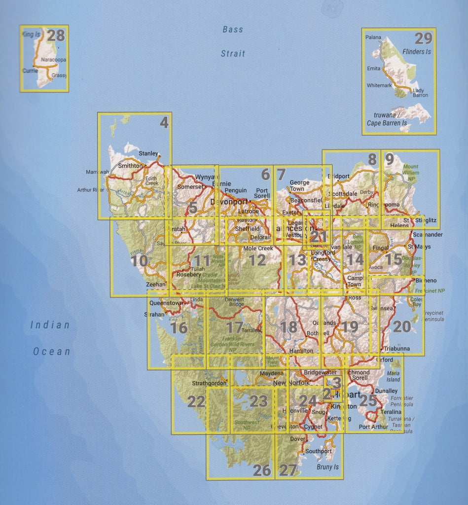
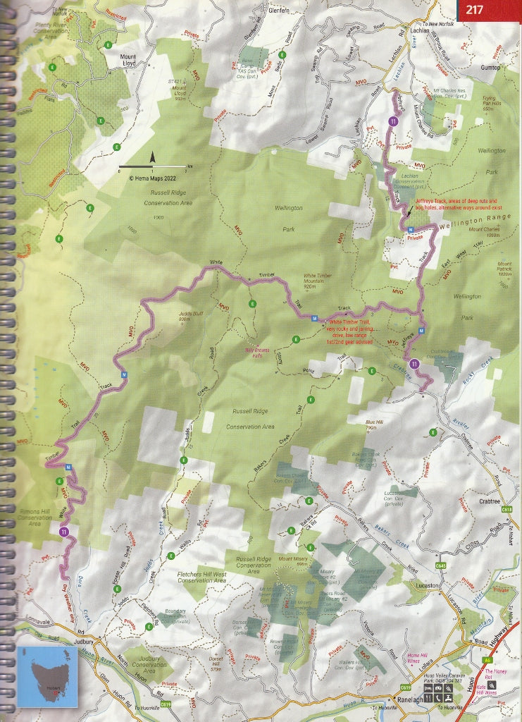
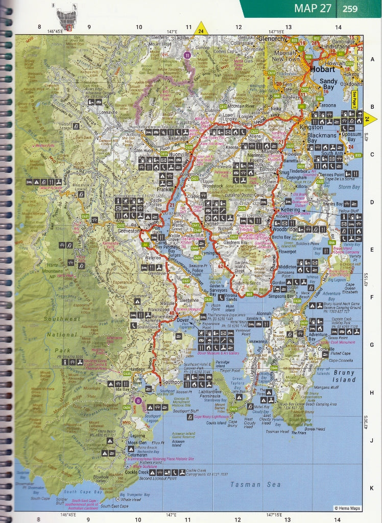
🗺️ 40 Pages of Large-Scale Atlas Mapping (1:150,000)
-
Provides unmatched clarity of Tasmania’s entire road network—sealed, unsealed, and 4WD
-
Includes topographic contours, rivers, tracks, parks, and tourist icons
-
Covers every corner of the island in rich, detailed cartographic style
🚙 Top 15 Tasmania 4WD Trips – Tested by Hema
-
Each 4WD adventure includes:
-
Difficulty grading
-
Trip distance
-
Region overview
-
Start and finish points
-
Key waypoints and landmarks
-
-
Routes range from beach tracks to alpine climbs, forest routes to highland plains
🥾 Tasmania’s Top 5 Bushwalks – Curated for All Levels
-
Whether you’re in for a leisurely forest amble or a full-day alpine challenge, these trails offer:
-
Scenic rewards, cultural highlights, and immersive nature experiences
-
Clear notes on track length, difficulty, access, and what to bring
-
⛺ Best Campsites for Every Traveller
-
Highlights free and paid campsites, caravan parks, National Park campgrounds, and hidden gems
-
Ideal for tent campers, campervans, caravans, and off-road setups
🧗♂️ Adventure Activities & Regional Travel Guides
-
Suggestions for:
-
Kayaking & fishing
-
Mountain biking
-
Historic walks & cultural detours
-
Wildlife viewing (from wombats to wedge-tailed eagles)
-
-
Every region includes touring notes, local tips, and must-see highlights
Practical Planning Tools Included
-
Introduction to Tasmania’s geography, climate, and road conditions
-
Tips for seasonal travel, fuel stops, remote safety, and gear recommendations
-
Permit information, National Park access, and 4WD track closures
📐 Product Specifications
| Feature | Description |
|---|---|
| Title | Tasmania Atlas & Guide |
| Edition | 2nd Edition |
| Publisher | Hema Maps |
| Format | Spiral-bound, full-colour, softcover |
| Pages | 40 atlas pages + guide content |
| Cartographic Scale | 1:150,000 |
| Content Highlights | Top 15 4WD trips, Top 5 walks, campsites |
| Dimensions | A4 size, opens flat for easy use in vehicles |
| Weight | Lightweight and glovebox-friendly |
| Print Quality | High-resolution with shaded relief maps |
| ISBN | [Available upon request] |
Who Is This Atlas For?
✔️ 4WD Tourers & Vanlifers exploring Tasmania’s wild backcountry
✔️ Hikers & Bushwalkers looking for the state’s best trails
✔️ Families & Grey Nomads planning an island-wide road trip
✔️ Travel agents & tourism operators curating off-grid experiences
✔️ Map collectors & cartography enthusiasts
✔️ Anyone seeking a reliable, physical navigation tool for remote Tasmania
Why Choose the Hema Tasmania Atlas?
Unlike mobile apps and digital-only resources, this guide is field-tested and crafted by explorers who have driven, walked, and mapped Tasmania from coast to coast. Hema’s Map Patrol doesn’t rely on satellites alone—they go out there and check things by hand. Every road, track, and trail has been recorded, verified, and curated to give you the best travel experience possible.
This isn’t just a map. It’s a travel companion.
🛒 Add to Cart Now – and prepare for your greatest Tasmanian adventure. Whether you’re planning a lap of the island, a weekend bushwalk, or your first 4WD expedition, the Tasmania Atlas & Guide by Hema is the indispensable tool to bring along for the ride.
Frequently Asked Questions
What does the Tasmania Atlas & Guide Hema cover?
This atlas covers the geographic region indicated in the product title, including roads, towns, distances, and key travel information. Mapworld stocks atlases for Australian states and territories, 4WD regions, and international destinations.
Is this the latest edition?
Yes, this is the latest edition. Mapworld stocks the most current editions available from publishers.
Is this atlas or guide spiral bound?
Spiral binding is indicated in the product title where applicable. Spiral-bound atlases and guides lay flat when open, making them ideal for use in vehicles or on a table without needing to hold pages open.
Is the Tasmania Atlas & Guide Hema in stock at Mapworld?
Mapworld maintains extensive stock across its map range and aims for fast dispatch. Orders placed before 2pm AEST on business days are typically dispatched the same day, with standard and express Australia-wide delivery options available.
Does Mapworld ship the Tasmania Atlas & Guide Hema across Australia?
Yes, Mapworld ships Australia-wide. Standard shipping is a flat $7 rate, with free standard shipping on orders over $75. Express options are available at checkout. Most orders placed before 2pm AEST on weekdays are dispatched same day.
Related Items

© 2026 Mapworld. Website designed by Genie Media
X