- Australia ▾
- Topographic
▾
- Australia AUSTopo 250k (2025)
- Australia 50k Geoscience maps
- Australia 100k Geoscience maps
- Australia 250k Geoscience maps
- Australia 1:1m Geoscience maps
- New Zealand 50k maps
- New Zealand 250k maps
- New South Wales 25k maps
- New South Wales 50k maps
- New South Wales 100k maps
- Queensland 10k maps
- Queensland 25k maps
- Queensland 50k maps
- Queensland 100k maps
- Western Australia 25k maps
- Western Australia 50k maps
- Western Australia 100k maps
- Compasses
- Software
- GPS Systems
- International ▾
- Wall Maps
▾
- World
- Australia & New Zealand
- Countries, Continents & Regions
- Historical
- Vintage National Geographic
- Australian Capital Territory
- New South Wales
- Northern Territory
- Queensland
- South Australia
- Tasmania
- Victoria
- Western Australia
- Celestial
- Children's
- Mining & Resources
- Wine Maps
- Healthcare
- Postcode Maps
- Electoral Maps
- Nautical ▾
- Flags
▾
- Australian Flag Sets & Banners
- Flag Bunting
- Handwavers
- Australian National Flags
- Aboriginal Flags
- Torres Strait Islander Flags
- International Flags
- Flagpoles & Accessories
- Australian Capital Territory Flags
- New South Wales Flags
- Northern Territory Flags
- Queensland Flags
- South Australia Flags
- Tasmania Flags
- Victoria Flags
- Western Australia Flags
- Gifts ▾
- Globes ▾
Dear valued customer. Please note that our checkout is not supported by old browsers. Please use a recent browser to access all checkout capabilities


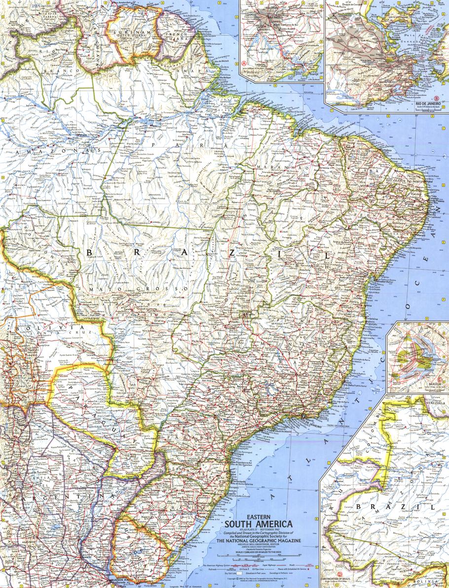
Eastern South America Wall Map - Published 1962 by National Geographic
$69.95
or make 4 interest-free payments of
$17.49 AUD
fortnightly with
![]() More info
More info
Size: 481 × 630 mm | Scale: 1:7,286,400 | Published: 1962 | Made in Australia
🌍 A 1960s Portrait of a Changing Continent
Step back to September 1962, when the vibrancy of Eastern South America was captured in rich National Geographic colour and precise mid-century cartography. This exceptional wall map was released alongside the feature article “Brazil, Oba!”, celebrating the nation’s energy, optimism, and cultural heartbeat during a decade of transformation.
The map is meticulously detailed, covering the eastern expanse of the continent with a focus on Brazil’s diverse landscapes—from the sweeping Amazon Basin to the Atlantic coastline dotted with thriving port cities.
Three beautifully illustrated inset maps provide close-up views of Brazil’s key urban centres:
-
Brasília – the newly inaugurated capital, a bold modernist experiment rising from the interior savanna.
-
Rio de Janeiro – a breathtaking coastal jewel framed by mountains and sea.
-
São Paulo – the booming industrial and economic powerhouse of South America.
Designed as a fine companion to National Geographic’s 1964 Northwestern South America map, it forms part of a stunning two-map set that chronicles the continent during a pivotal period in its history.
📐 Cartographic Features
-
Inset Maps: Brasília, Rio de Janeiro, and São Paulo.
-
Geographic Coverage: Eastern Brazil, Uruguay, Paraguay, Suriname, French Guiana, and portions of Argentina and Venezuela.
-
Detail Level: Political boundaries, major transport routes, topographic relief, rivers, coastal features, and key settlements.
-
Colouration: Vibrant yet refined, in the classic mid-century National Geographic palette.
🖌 Premium Print & Display Options
| Format | Description |
|---|---|
| Paper (160 gsm) | Heavyweight matte-coated paper – perfect for archival framing under glass. |
| Laminated | Encapsulated in two sheets of 80-micron gloss laminate for outstanding durability and water resistance. |
| Laminated + Hang Rails | Laminated map with smooth natural timber rails and a hanging cord – display-ready on arrival. |
| Canvas (395 gsm) | Printed on HP Professional Matte Canvas using archival pigment inks for rich texture and fade resistance. |
| Canvas + Hang Rails | Canvas map finished with natural timber hang rails for a timeless, heritage-style presentation. |
Note: Please allow up to 10 working days for delivery of hang-railed maps, as each is professionally mounted by our framer.
🎯 Perfect For
-
Map Collectors – An authentic reproduction of a 1960s National Geographic classic.
-
Brazil Enthusiasts – See Brazil’s urban and rural landscapes at a key historical moment.
-
Educators & Historians – A valuable resource for teaching South American political and cultural geography of the era.
-
Interior Design – A striking conversation piece for libraries, studies, offices, or travel-themed spaces.
🌟 Why This Map Stands Out
-
Historic Provenance – Published alongside one of National Geographic’s most celebratory features on Brazil.
-
Urban Insets – Detailed city plans offering rare mid-century cartographic perspectives of Brazil’s major cities.
-
Exceptional Print Quality – Crisp, vibrant, and designed to endure.
-
Australian Made – Printed locally to professional archival standards.
Celebrate the colour, energy, and geography of Eastern South America in the 1960s. This National Geographic wall map captures a moment in time when Brazil was redefining itself on the global stage, offering a compelling blend of artistry, accuracy, and history.
📍 Order yours today to own a museum-quality reproduction of one of the most beautiful South American maps ever published.
Frequently Asked Questions
What are the dimensions of the Eastern South America Wall Map - Published 1962 by National Geographic?
Mapworld wall maps range from standard 700×1000mm to large-format 1000×1430mm Supermaps. The exact dimensions for this map are shown in the product title. Where multiple sizes are available, select your preferred size when adding to cart.
Is this wall map available laminated?
Many Mapworld wall maps are available in paper, laminated, or framed finishes. Check the product options when adding to cart. Laminated maps are wipe-clean and more durable.
Is this the latest edition?
Mapworld stocks the most current editions available from all publishers. Edition year is shown in the product title where applicable. Mapworld updates its catalogue as new editions are released.
Can I write on or pin this wall map?
Laminated wall maps can be written on with whiteboard markers and wiped clean. Paper maps can be pinned on a corkboard. Choose a laminated option for a writeable surface.
Does Mapworld ship the Eastern South America Wall Map - Published 1962 by National Geographic across Australia?
Yes, Mapworld ships Australia-wide. Standard shipping is a flat $7 rate, with free standard shipping on orders over $75. Express options are available at checkout. Most orders placed before 2pm AEST on weekdays are dispatched same day.
Related Items


© 2026 Mapworld. Website designed by Genie Media
X