- Australia ▾
- Topographic
▾
- Australia AUSTopo 250k (2024)
- Australia 50k Geoscience maps
- Australia 100k Geoscience maps
- Australia 250k Geoscience maps
- Australia 1.1m Geoscience maps
- New Zealand 50k maps
- New Zealand 250k maps
- New South Wales 25k maps
- New South Wales 50k maps
- New South Wales 100k maps
- Queensland 10k maps
- Queensland 25k maps
- Queensland 50k maps
- Queensland 100k maps
- Compasses
- Software
- GPS Systems
- Orienteering
- International ▾
- Wall Maps
▾
- World
- Australia & New Zealand
- Countries, Continents & Regions
- Historical
- Vintage National Geographic
- Australian Capital Territory
- New South Wales
- Northern Territory
- Queensland
- South Australia
- Tasmania
- Victoria
- Western Australia
- Celestial
- Children's
- Mining & Resources
- Wine Maps
- Healthcare
- Postcode Maps
- Electoral Maps
- Nautical ▾
- Flags
▾
- Australian Flag Sets & Banners
- Flag Bunting
- Handwavers
- Australian National Flags
- Aboriginal Flags
- Torres Strait Islander Flags
- International Flags
- Flagpoles & Accessories
- Australian Capital Territory Flags
- New South Wales Flags
- Northern Territory Flags
- Queensland Flags
- South Australia Flags
- Tasmania Flags
- Victoria Flags
- Western Australia Flags
- Gifts ▾
- Globes ▾
Dear valued customer. Please note that our checkout is not supported by old browsers. Please use a recent browser to access all checkout capabilities
Cocos (Keeling) Islands Geoscience Map
$19.95
Afterpay is only available for orders between $50.00 and $1000.00 More info
🏝️ Australia’s Remote Indian Ocean Paradise – Captured in Cartographic Detail
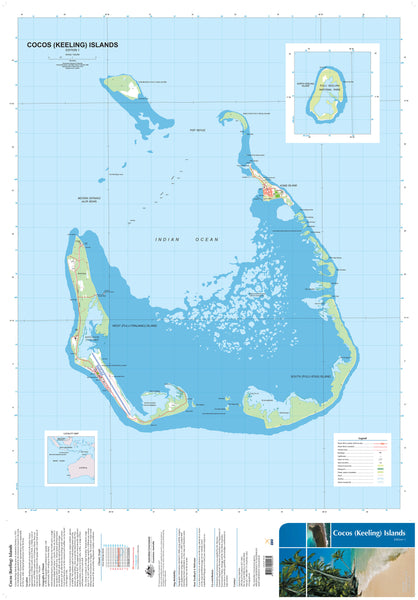
Step into the heart of the Indian Ocean with this beautifully detailed topographic map of the Cocos (Keeling) Islands, produced by Geoscience Australia. At once a rare geographic document and a striking visual statement, this map provides an unparalleled look at one of Australia’s most isolated and pristine tropical territories.
Whether you're an educator, conservationist, field researcher, or world map collector, this is your gateway to the history, ecology, and wonder of the Cocos (Keeling) Islands.
🌍 About the Islands
Situated at 12°10′S, 96°50′E, more than 2,700 km northwest of Perth, the Cocos (Keeling) Islands are a collection of 27 coral islands formed into two magnificent atolls. With only 14 square kilometres of land and a small population of just over 570 people, most of whom live on Home Island and West Island, this Territory remains one of the last truly untouched tropical environments in Australia’s domain.
🐦 A Wildlife Haven
Cocos is home to an abundance of seabirds, land crabs, turtles, and marine creatures. The surrounding coral reefs teem with fish, molluscs, crustaceans, and rich underwater biodiversity, while North Keeling Island—the only island in the northern atoll—is protected as Pulu Keeling National Park, Australia’s most remote Commonwealth National Park.
The area is globally recognised as a critical seabird rookery and conservation area of international significance.
🧭 A Slice of History
First sighted by Captain William Keeling in 1609, the islands weren’t settled until 1826, when Alexander Hare brought labourers to establish a coconut plantation. A year later, John Clunies-Ross, a former associate of Hare, arrived and began shaping the islands’ unique social and political legacy—eventually receiving formal possession from Britain in 1886.
In 1978, the Australian Government purchased the islands from the Clunies-Ross family. By 1984, the islanders had voted to retain their status as part of Australia in a landmark act of democratic self-determination.
🗺️ Map Features
-
Highly detailed topographic design showing coastlines, reef outlines, land contours, and infrastructure
-
Exceptional 1:25,000 scale for clarity and precision
-
Ideal for environmental studies, marine navigation reference, field use, or decorative display
-
Produced by Geoscience Australia, ensuring trusted accuracy and quality
Finishing Options
| Finish | Description |
|---|---|
| Tyvek® Waterproof | Tearproof and waterproof. Perfect for fieldwork in humid or wet conditions. Made from polyethylene fibres, Tyvek® folds like paper but resists water, dirt, and tearing. |
| Laminated (Gloss) | Sealed between two sheets of 80-micron gloss laminate. Durable, wipeable, and markable with whiteboard pens. Excellent for planning or map-dot displays. |
Both options are printed using fade-resistant pigment-based inks by Hewlett-Packard, ensuring archival quality and rich visual clarity.
📐 Specifications
| Attribute | Details |
|---|---|
| Scale | 1:25,000 |
| Map Size | 700 mm (W) × 1000 mm (H) |
| Cartographer | Geoscience Australia |
| Finish Options | Tyvek Waterproof or Gloss Laminated |
| Inks | Archival-grade HP pigment-based inks |
| Printed In | Australia |
🎯 Perfect For:
-
Ecologists, marine scientists & field researchers studying reef environments or island topography
-
Educators & students seeking an accurate resource for environmental or geographical curricula
-
Travel planners or divers exploring this remote tropical paradise
-
Collectors & history enthusiasts who cherish unique Australian territories
-
Decorators & designers seeking rare and beautiful island cartography for office, studio, or home walls
🛠️ Note: Please allow up to 5-10 working days for delivery of Tyvek or laminated maps, as each is professionally printed and finished to order.
Bring the remote beauty, unique history, and ecological richness of Cocos (Keeling) Islands into your world with this stunning, informative wall map—a true celebration of one of Australia’s most fascinating island territories.


