- Australia ▾
- Topographic
▾
- Australia AUSTopo 250k (2024)
- Australia 50k Geoscience maps
- Australia 100k Geoscience maps
- Australia 250k Geoscience maps
- Australia 1.1m Geoscience maps
- New Zealand 50k maps
- New Zealand 250k maps
- New South Wales 25k maps
- New South Wales 50k maps
- New South Wales 100k maps
- Queensland 10k maps
- Queensland 25k maps
- Queensland 50k maps
- Queensland 100k maps
- Compasses
- Software
- GPS Systems
- Orienteering
- International ▾
- Wall Maps
▾
- World
- Australia & New Zealand
- Countries, Continents & Regions
- Historical
- Vintage National Geographic
- Australian Capital Territory
- New South Wales
- Northern Territory
- Queensland
- South Australia
- Tasmania
- Victoria
- Western Australia
- Celestial
- Children's
- Mining & Resources
- Wine Maps
- Healthcare
- Postcode Maps
- Electoral Maps
- Nautical ▾
- Flags
▾
- Australian Flag Sets & Banners
- Flag Bunting
- Handwavers
- Australian National Flags
- Aboriginal Flags
- Torres Strait Islander Flags
- International Flags
- Flagpoles & Accessories
- Australian Capital Territory Flags
- New South Wales Flags
- Northern Territory Flags
- Queensland Flags
- South Australia Flags
- Tasmania Flags
- Victoria Flags
- Western Australia Flags
- Gifts ▾
- Globes ▾
Dear valued customer. Please note that our checkout is not supported by old browsers. Please use a recent browser to access all checkout capabilities
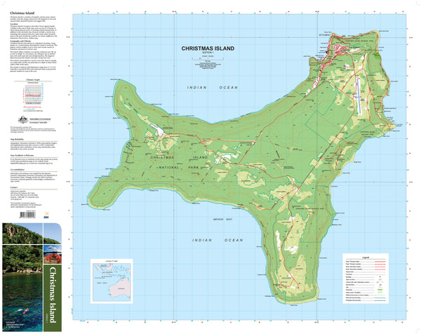
Christmas Island Geoscience Map
$19.95
Afterpay is only available for orders between $50.00 and $1000.00 More info
🏝️ Christmas Island Geoscience Map – Explore the Summit of a Submarine Mountain
A Gateway to One of Australia’s Most Isolated and Fascinating Territories
Set adrift in the vast Indian Ocean, Christmas Island is a place of extraordinary contrasts—an ancient coral-capped volcano cloaked in rainforest, ringed by plunging reefs, and home to one of the most bizarre wildlife migrations on the planet. This detailed topographic map by Geoscience Australia offers a comprehensive and beautifully rendered overview of this remote Australian territory, making it a superb resource for travellers, divers, naturalists, and educators alike.
🌋 About the Island
Situated 2,300 kilometres northwest of Perth, Christmas Island rises steeply from the ocean floor—its landmass the exposed summit of a vast underwater mountain. The island stretches over 135 square kilometres, with over 60% protected as Christmas Island National Park, preserving pristine rainforest, rugged coastline, and rare wildlife.
The central plateau, reaching up to 361 metres above sea level, is made up of ancient limestone terraces and volcanic rock layers, surrounded by a narrow reef that drops off almost immediately into the abyss—creating some of the steepest undersea cliffs in the world. These formations are a magnet for divers, with coral walls plunging to depths of 500 metres just 200 metres from shore.
🦀 A Natural Wonder
Christmas Island is globally famous for its spectacular red crab migration. Each year, over 50 million crabs emerge from the forest to cross roads, climb cliffs, and swarm beaches in their journey to the sea. It's been described as one of the great natural wonders of the world.
Alongside the red crabs are more than 20 species of land and intertidal crabs, including the robber crab (or coconut crab)—the world’s largest land invertebrate, capable of cracking coconuts with its powerful claws.
🛠️ A Land of Transformation
Since the late 1800s, Christmas Island has seen extensive phosphate mining, derived from millennia of seabird guano. Today, the island’s focus is shifting toward eco-tourism and conservation, with its marine biodiversity and unique ecosystem drawing increasing global attention.
🗺️ Map Features
This detailed map by Geoscience Australia captures Christmas Island at an exceptional scale of 1:30,000, offering clear topographic detail and rich physical data, ideal for:
-
Scientific study
-
Adventure planning
-
Environmental education
-
Diving and marine mapping
-
General reference or wall display
🎨 Finishing Options
| Finish | Description |
|---|---|
| Tyvek® Waterproof | Tearproof and waterproof – perfect for field use. Tyvek® is made from spunbonded polyethylene fibres, combining the feel of paper with the strength of synthetic fabric. Ideal for researchers, outdoor explorers, and rugged travel. |
| Laminated (Gloss) | Sealed in 80-micron gloss laminate on both sides. You can write on it with whiteboard markers, apply Map Dots, or use pins without damage. Excellent for walls, planning, or frequent handling. |
📐 Map Specifications
| Attribute | Details |
|---|---|
| Scale | 1:30,000 |
| Dimensions | 700 mm (W) × 1000 mm (H) |
| Publisher | Geoscience Australia |
| Finish Options | Tyvek Waterproof or Gloss Laminated |
| Inks | Archival-grade pigment inks by Hewlett-Packard |
| Printed In | Australia |
🎯 Who Is This Map For?
-
Marine biologists, divers & conservationists tracking reef topography and biodiversity
-
Wildlife lovers & photographers following the red crab migration
-
Educators & students studying geology, ecology, or remote Australian territories
-
Eco-tourists & explorers planning immersive experiences in one of Earth’s most unique environments
-
Collectors of rare Australian cartography and natural heritage maps
-
Decorators seeking a visually striking, conversation-starting wall piece
Bring one of Australia’s most extraordinary natural locations to your wall or field pack with this powerful and precise representation of Christmas Island—a landscape like nowhere else on Earth.
🛒 Note: Please allow 5 - 10 working days for laminated and Tyvek versions, as each map is produced with premium materials and finishing care.


