- Australia ▾
- Topographic
▾
- Australia AUSTopo 250k (2024)
- Australia 50k Geoscience maps
- Australia 100k Geoscience maps
- Australia 250k Geoscience maps
- Australia 1.1m Geoscience maps
- New Zealand 50k maps
- New Zealand 250k maps
- New South Wales 25k maps
- New South Wales 50k maps
- New South Wales 100k maps
- Queensland 10k maps
- Queensland 25k maps
- Queensland 50k maps
- Queensland 100k maps
- Compasses
- Software
- GPS Systems
- Orienteering
- International ▾
- Wall Maps
▾
- World
- Australia & New Zealand
- Countries, Continents & Regions
- Historical
- Vintage National Geographic
- Australian Capital Territory
- New South Wales
- Northern Territory
- Queensland
- South Australia
- Tasmania
- Victoria
- Western Australia
- Celestial
- Children's
- Mining & Resources
- Wine Maps
- Healthcare
- Postcode Maps
- Electoral Maps
- Nautical ▾
- Flags
▾
- Australian Flag Sets & Banners
- Flag Bunting
- Handwavers
- Australian National Flags
- Aboriginal Flags
- Torres Strait Islander Flags
- International Flags
- Flagpoles & Accessories
- Australian Capital Territory Flags
- New South Wales Flags
- Northern Territory Flags
- Queensland Flags
- South Australia Flags
- Tasmania Flags
- Victoria Flags
- Western Australia Flags
- Gifts ▾
- Globes ▾
Dear valued customer. Please note that our checkout is not supported by old browsers. Please use a recent browser to access all checkout capabilities
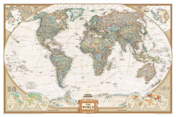
World Executive Antique Style National Geographic 1170 x 770mm (Africa Centred) Wall Map
$89.95
or make 4 interest-free payments of
$22.49 AUD
fortnightly with
![]() More info
More info
🌍 World Executive Antique-Style Map – Africa-Centred
By National Geographic Society
Size: 1170 mm (W) × 770 mm (H) | Projection: Winkel Tripel | Scale: 1:36,384,000
Finish Options: Paper, Laminated, or Canvas | Optional: Timber Hang Rails
Made in Australia
🗺 A World Map with History in Every Hue
Step into a tradition of cartographic excellence with the Africa-Centred World Executive Political Map by National Geographic.
With its antique-style palette of warm earth tones, this is not just a map—it’s a statement piece, a storytelling tool, and a work of art steeped in both beauty and precision.
Designed to capture the romance of exploration while delivering uncompromising geographical accuracy, it brings the whole world into sharper focus—centred on Africa for a fresh, globally balanced view.
Perfect for homes, offices, classrooms, or libraries, it blends timeless style with the authority of National Geographic’s trusted cartography.
📌 Exceptional Cartographic Detail
Africa-Centred Perspective
-
Moves away from Eurocentric layouts to give Africa—and the surrounding continents—its rightful central place.
-
Ideal for stimulating conversations about global relationships, trade routes, and cultural connections.
Winkel Tripel Projection
-
National Geographic’s preferred projection for reducing distortion of shapes and sizes.
-
Creates a visually harmonious and geographically accurate representation of the Earth.
Antique-Inspired Design
-
Rich, muted tones evoke the golden age of exploration.
-
Borders, capitals, major cities, and key geographic features are labelled with clarity.
-
Mountain ranges, rivers, deserts, and islands appear with subtle shaded relief for depth and realism.
Inset Maps for Added Insight
-
Population Density – Understand where humanity clusters across the globe.
-
Vegetation & Land Use – Visualise how the Earth’s surface is shaped by nature and agriculture.
-
Global Terrain Shading – Appreciate elevation and landforms at a glance.
🖼 Premium Finish Options
📄 Heavyweight Paper (160 gsm)
-
Smooth matte finish for archival-quality prints.
-
Perfect for framing behind glass or mounting with clips.
-
Ships rolled in a protective mailing tube.
💧 Encapsulated Gloss Laminate
-
Fully sealed between two layers of 80-micron gloss laminate.
-
Waterproof, tear-resistant, and UV-protected.
-
Wipe-clean surface—ideal for classrooms, offices, or frequent use.
-
Compatible with whiteboard markers and travel dots.
🎨 HP Professional Matte Canvas (395 gsm)
-
Printed with archival pigment-based inks for rich, fade-resistant colour.
-
Luxurious texture that gives the impression of a vintage wall hanging.
-
Long-lasting, waterproof, and ready for display with optional hang rails.
🪵 Optional Timber Hang Rails – Effortless, Elegant Display
-
Smooth natural lacquered finish complements the map’s warm antique tones.
-
Top and bottom rails keep the map flat and secure.
-
Pre-fitted hanging cord—just add a hook to your wall.
-
No need for custom framing—ideal for a gallery-quality presentation at a fraction of the cost.
Please allow up to 10 working days for delivery of hang-railed versions, as each is professionally mounted by our framing team.
📏 Specifications
| Feature | Details |
|---|---|
| Publisher | National Geographic Society |
| Projection | Winkel Tripel |
| Map Style | Political – Antique Style, Africa-Centred |
| Inset Maps | Population Density, Vegetation, Land Use |
| Available Finishes | Paper, Laminated, Canvas |
| Optional Mounting | Natural Timber Hang Rails |
| Scale | 1:36,384,000 |
| Dimensions | 1170 mm (W) × 770 mm (H) |
| Made In | Australia |
🌟 Why This Map Belongs on Your Wall
-
✅ Visual Impact – Antique tones that warm a room and invite the eye.
-
✅ Educational Value – Insets, projection choice, and detail make it a learning tool as much as art.
-
✅ Durability – Laminated and canvas finishes ensure years of use.
-
✅ Prestige – Crafted by National Geographic, trusted by explorers, educators, and collectors worldwide.
📚 Perfect For:
✔️ Educators & Geography Enthusiasts
✔️ World Travellers & Planners
✔️ Professional Offices & Boardrooms
✔️ Home Decor with a Story
✔️ Gifts for Scholars, Diplomats & History Lovers
✨ Final Word
The National Geographic World Executive Antique-Style Map does more than show you where countries lie—it connects you to the spirit of discovery, the sweep of history, and the living patterns of our modern world.
It’s as informative as it is inspiring, equally suited for quiet study, active teaching, or simply appreciating the vast beauty of our planet.
Order today and let the world take pride of place on your wall—crafted with precision, designed with elegance, and built to last.


