- Australia ▾
- Topographic
▾
- Australia AUSTopo 250k (2024)
- Australia 50k Geoscience maps
- Australia 100k Geoscience maps
- Australia 250k Geoscience maps
- Australia 1.1m Geoscience maps
- New Zealand 50k maps
- New Zealand 250k maps
- New South Wales 25k maps
- New South Wales 50k maps
- New South Wales 100k maps
- Queensland 10k maps
- Queensland 25k maps
- Queensland 50k maps
- Queensland 100k maps
- Compasses
- Software
- GPS Systems
- Orienteering
- International ▾
- Wall Maps
▾
- World
- Australia & New Zealand
- Countries, Continents & Regions
- Historical
- Vintage National Geographic
- Australian Capital Territory
- New South Wales
- Northern Territory
- Queensland
- South Australia
- Tasmania
- Victoria
- Western Australia
- Celestial
- Children's
- Mining & Resources
- Wine Maps
- Healthcare
- Postcode Maps
- Electoral Maps
- Nautical ▾
- Flags
▾
- Australian Flag Sets & Banners
- Flag Bunting
- Handwavers
- Australian National Flags
- Aboriginal Flags
- Torres Strait Islander Flags
- International Flags
- Flagpoles & Accessories
- Australian Capital Territory Flags
- New South Wales Flags
- Northern Territory Flags
- Queensland Flags
- South Australia Flags
- Tasmania Flags
- Victoria Flags
- Western Australia Flags
- Gifts ▾
- Globes ▾
Dear valued customer. Please note that our checkout is not supported by old browsers. Please use a recent browser to access all checkout capabilities
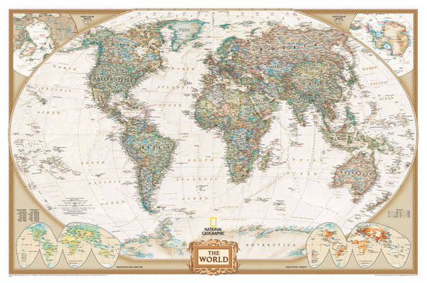
World Executive Antique Style National Geographic 1540 x 1020mm (Africa Centred) Large Wall Map
$129.95
or make 4 interest-free payments of
$32.49 AUD
fortnightly with
![]() More info
More info
A Grand View of the World in Antique Elegance
Step into a world of timeless geography and refined design with the World Executive Political Map by National Geographic. Designed to be both informative and inspirational, this exquisite wall map presents the world’s political boundaries with an antique-style palette that evokes the golden age of cartography.
With a sweeping span of 1540 mm wide by 1020 mm high, this map offers a comprehensive, up-to-date view of the globe, printed with exceptional clarity and rich earth-tone colours that seamlessly suit formal offices, classrooms, libraries, and living spaces alike.
🌐 A World of Detail at a Glance
This political wall map goes beyond simple boundaries. It incorporates:
-
🗺️ Meticulously Researched Political Boundaries
Reflecting current international divisions and capitals, constantly updated by National Geographic’s team of cartographers. -
🌍 Winkel Tripel Projection
This acclaimed projection balances shape and area to minimize distortion—especially important when depicting the poles—while maintaining the integrity of continent shapes. Greenland, for example, is shown in accurate proportion to South America and Africa. -
📊 Inset Thematic Maps
Discover more with insets in the lower corners that show:-
Global population density
-
Land use patterns
-
Vegetation zones
These mini-maps provide an at-a-glance understanding of how people live and interact with the planet.
-
-
🏙️ Thousands of Place Names
Major cities, capitals, island groups, rivers, and mountain ranges are clearly labelled, allowing for both macro-level and detailed exploration.
🎨 Visual Impact Meets Functionality
What sets this map apart is its stunning antique-inspired aesthetic, with subtle browns, creams, and greens that emulate the look of aged parchment. The effect is both calming and authoritative—a piece that draws the eye while communicating credibility.
Whether used as a decorative centrepiece or a functional reference tool, this map is as much art as it is geography.
📐 Formats and Specifications
| Feature | Details |
|---|---|
| Scale | 1:22,445,000 |
| Map Size | 1540 mm (width) x 1020 mm (height) |
| Projection | Winkel Tripel (National Geographic standard) |
| Published | 2020 |
| Printed In | Australia |
| Languages | English |
📄 Format Options
Choose the finish that suits your needs, space, and style:
📜 Paper – 160 gsm Premium Stock
-
Ideal for framing under glass
-
Smooth matte finish with vibrant, archival-quality ink
-
Lightweight, rollable, and easy to handle
💧 Laminated – 80 Micron Gloss Encapsulation
-
Printed on premium paper then fully encapsulated in two layers of tough 80-micron gloss laminate
-
Wipeable surface for use with whiteboard markers
-
Resists tears, spills, creases, and fingerprints—great for schools, libraries, or travel offices
🖼️ Canvas – 395 gsm HP Matte Canvas
-
Printed using long-lasting pigment-based inks
-
Offers a rich texture, similar to fine art prints
-
Fade-resistant and exceptionally durable
-
Perfect for high-end décor or frequent handling
🪵 Optional Hanging System
Add a touch of classic charm and convenience with our optional wooden hang rails:
-
Top and bottom wooden battens, lacquered in a natural finish
-
A discreet hanging cord runs across the top rail for easy wall display
-
No framing needed—simply hang on a single wall hook or nail
-
Perfect for renters or spaces where you’d prefer not to mount a full frame
🛠️ Please allow up to 10 working days for dispatch when ordering hang-railed maps, as each set is professionally assembled by hand.
🧠 Who Is This Map For?
This map is designed to meet the needs of a wide variety of users:
| 🎓 Educators | Ideal for classrooms and homeschooling environments |
| 🗺️ Travellers | Great for route planning, bucket lists, and inspiration |
| 🧑🏫 Presenters | A professional backdrop for presentations and discussions |
| 📚 Collectors | A worthy addition to any map or globe collection |
| 🏢 Professionals | Adds intelligence and character to any office or boardroom |
| 🏡 Families | A talking point for kids and guests alike at home |
🛒 Why Choose a National Geographic Map?
For over 130 years, National Geographic has been synonymous with excellence in cartography. Their maps are created by expert geographers, backed by scientific research and crafted with care.
-
✔️ Trusted by educators and institutions worldwide
-
✔️ Accurate and current political data
-
✔️ Visually stunning—blends seamlessly with traditional and modern interiors
-
✔️ Made to last—whether on paper, laminate, or canvas
📦 Shipping & Delivery
-
Rolled in a protective mailing tube to ensure safe arrival
-
Laminated and canvas maps available flat or with hang rails
-
Made and shipped from Australia
📅 Delivery with hang rails may take up to 10 business days due to the manual framing process.
🌎 Bring the World to Your Wall
Whether you're tracing ancient trade routes, marking countries visited, or simply admiring the layout of our beautiful planet, the National Geographic World Executive Political Map transforms any space into a portal to global understanding.
Order yours today and let the world inspire your walls.


