- Australia ▾
- Topographic
▾
- Australia AUSTopo 250k (2024)
- Australia 50k Geoscience maps
- Australia 100k Geoscience maps
- Australia 250k Geoscience maps
- Australia 1.1m Geoscience maps
- New Zealand 50k maps
- New Zealand 250k maps
- New South Wales 25k maps
- New South Wales 50k maps
- New South Wales 100k maps
- Queensland 10k maps
- Queensland 25k maps
- Queensland 50k maps
- Queensland 100k maps
- Compasses
- Software
- GPS Systems
- Orienteering
- International ▾
- Wall Maps
▾
- World
- Australia & New Zealand
- Countries, Continents & Regions
- Historical
- Vintage National Geographic
- Australian Capital Territory
- New South Wales
- Northern Territory
- Queensland
- South Australia
- Tasmania
- Victoria
- Western Australia
- Celestial
- Children's
- Mining & Resources
- Wine Maps
- Healthcare
- Postcode Maps
- Electoral Maps
- Nautical ▾
- Flags
▾
- Australian Flag Sets & Banners
- Flag Bunting
- Handwavers
- Australian National Flags
- Aboriginal Flags
- Torres Strait Islander Flags
- International Flags
- Flagpoles & Accessories
- Australian Capital Territory Flags
- New South Wales Flags
- Northern Territory Flags
- Queensland Flags
- South Australia Flags
- Tasmania Flags
- Victoria Flags
- Western Australia Flags
- Gifts ▾
- Globes ▾
Dear valued customer. Please note that our checkout is not supported by old browsers. Please use a recent browser to access all checkout capabilities
World Hema Political (Pacific) Classic 1010 x 650mm Large Wall Map
$59.95
or make 4 interest-free payments of
$14.99 AUD
fortnightly with
![]() More info
More info
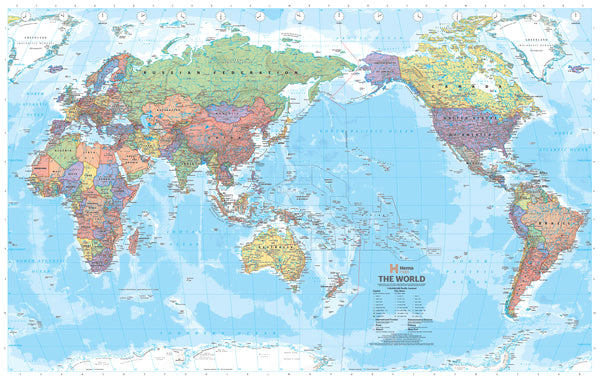
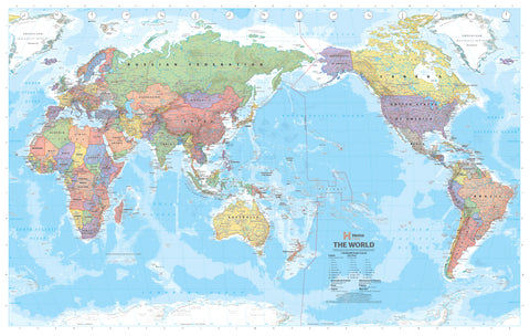
A beautifully rendered political map of the world with a unique Asia-Pacific focus — ideal for the home, office, or classroom
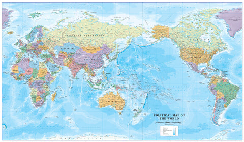
The Hema Pacific-Centred World Political Map offers a fresh and regionally relevant view of the globe. Unlike traditional Atlantic-centred maps, this design places the Pacific Ocean and surrounding countries — including Australia, New Zealand, Southeast Asia, and the Pacific Islands — at the centre of the world. This perspective not only better reflects the Asia-Pacific’s global connections, but also provides a clearer understanding of geographic relationships for viewers in this part of the world.
This map is more than just informative — it’s designed to be visually captivating. Countries are shaded in subtle, muted pastels that distinguish political boundaries without overwhelming the eye, while the oceans are shaded in rich, graduated blues that hint at underwater topography and depth. The result is a clean, modern look that balances form and function.
🗺️ Map Specifications:
-
Title: World Political Map – Pacific-Centred (Hema Maps)
-
Scale: 1:40,000,000
-
Projection: Pacific-centred world view
-
Size: 1010 mm (width) x 650 mm (height)
-
Map Type: Political (country borders, capital cities, major cities, island groups, and key geopolitical boundaries)
📄 Available Finishes & Materials:
1. 170 gsm Premium Paper
-
Crisp, matte finish suitable for professional framing under glass
-
Perfect for display in offices, study rooms, libraries, or educational settings
2. Laminated (Encapsulated in 80-Micron Gloss Laminate)
-
Fully sealed with a true double-sided encapsulation, not just surface lamination
-
Tough and wipe-clean surface ideal for use with whiteboard markers
-
Designed for high-use environments such as schools, logistics offices, and travel agencies
-
Offers superior protection against tears, spills, and UV fading
3. 395 gsm HP Professional Matte Canvas
-
Printed with archival pigment-based inks for rich colour and fade-resistance
-
Exceptional print resolution for enhanced clarity and texture
-
Durable, flexible, and resistant to humidity and handling, making it an ideal choice for long-term display
-
Offers a gallery-quality appearance — perfect for homes, offices, or presentation rooms
🖼️ Optional Hang-Railed Canvas Version:
Upgrade your canvas map with a custom timber hanging system, turning it into an elegant, ready-to-hang piece:
-
Natural timber rails attached to the top and bottom of the canvas
-
Lacquered finish enhances the wood’s grain while protecting it
-
Hanging cord on the top rail makes installation quick and simple — just place a hook on the wall
-
A stylish, functional alternative to framing, perfect for renters or mobile displays
🕒 Please allow up to 10 working days for the hang-rail system to be professionally attached by our framing partner.
🌏 Why a Pacific-Centred Map?
A Pacific-centred projection reshapes how we think about global geography:
-
Puts Australia, New Zealand, and the Pacific Islands at the centre, not the periphery
-
Highlights important trans-Pacific connections, including trade, migration, and geopolitics
-
Offers a more balanced global view for users based in the Southern Hemisphere
-
Ideal for students and professionals who require a perspective that reflects our real-world position
✅ Uses and Applications:
-
Educational: Excellent for teaching world geography with a regional focus
-
Decorative: A stunning wall piece for living rooms, studies, or offices
-
Professional: Ideal for consultants, logistics planners, global teams, travel advisors, and remote workers
-
Gift Idea: Makes a thoughtful and practical gift for geography lovers, globetrotters, and teachers
Whether you're plotting your travels, decorating your workspace, teaching global awareness, or simply appreciating the art of cartography, the Hema World Political Map – Pacific-Centred Edition is both a functional resource and a sophisticated statement piece.
Expand your world — from the place you call home.
Made in Australia


