- Australia ▾
- Topographic
▾
- Australia AUSTopo 250k (2024)
- Australia 50k Geoscience maps
- Australia 100k Geoscience maps
- Australia 250k Geoscience maps
- Australia 1.1m Geoscience maps
- New Zealand 50k maps
- New Zealand 250k maps
- New South Wales 25k maps
- New South Wales 50k maps
- New South Wales 100k maps
- Queensland 10k maps
- Queensland 25k maps
- Queensland 50k maps
- Queensland 100k maps
- Compasses
- Software
- GPS Systems
- Orienteering
- International ▾
- Wall Maps
▾
- World
- Australia & New Zealand
- Countries, Continents & Regions
- Historical
- Vintage National Geographic
- Australian Capital Territory
- New South Wales
- Northern Territory
- Queensland
- South Australia
- Tasmania
- Victoria
- Western Australia
- Celestial
- Children's
- Mining & Resources
- Wine Maps
- Healthcare
- Postcode Maps
- Electoral Maps
- Nautical ▾
- Flags
▾
- Australian Flag Sets & Banners
- Flag Bunting
- Handwavers
- Australian National Flags
- Aboriginal Flags
- Torres Strait Islander Flags
- International Flags
- Flagpoles & Accessories
- Australian Capital Territory Flags
- New South Wales Flags
- Northern Territory Flags
- Queensland Flags
- South Australia Flags
- Tasmania Flags
- Victoria Flags
- Western Australia Flags
- Gifts ▾
- Globes ▾
Dear valued customer. Please note that our checkout is not supported by old browsers. Please use a recent browser to access all checkout capabilities
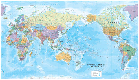
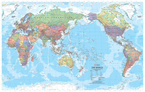
World Executive Antique Style National Geographic 1852 x 1219mm (Pacific Centred) Super Laminated Wall Map with Hang Rails
$499.95
or make 4 interest-free payments of
$124.99 AUD
fortnightly with
![]() More info
More info
By National Geographic | Size: 1852 mm (W) x 1219 mm (H) | Antique Style | Pacific-Focused | Ready to Hang
A Classic Reimagined for the Southern Hemisphere
Commanding in size and refined in appearance, this Pacific-Centred World Executive Political Map by National Geographic is a captivating blend of antique cartographic charm and contemporary geographical accuracy. Encapsulated in premium gloss laminate and professionally fitted with timber hang rails, this edition is ready to transform your wall into a portal to the wider world.
Designed with a deep respect for history and a clear eye on the present, the map’s soothing earth tones and intricate detail make it equally suited to boardrooms, libraries, classrooms, and sophisticated home interiors.
🌐 A Pacific-Centred Perspective
Unlike traditional Euro- or Africa-centred maps, this version reorients the globe to place the Pacific Ocean and Asia-Pacific nations at its heart. This layout is ideal for users in Australia, New Zealand, and the wider Pacific region, offering a geographically intuitive view of global relationships, trade routes, and geopolitical connections.
🗺️ Key Features & Cartographic Detail
-
Antique-Style Palette
Rich tones of ochre, sage, parchment and ocean blue bring vintage appeal while enhancing readability. -
Winkel Tripel Projection
Minimises distortion in area, distance, and direction—favoured by National Geographic for its balance of aesthetic and accuracy. -
Extensive Political Data
Includes clearly defined international boundaries, capitals, major cities, island groups, rivers, and mountain ranges. -
Inset Thematic Maps
Found in the lower corners, these offer insight into:-
🌍 Global population density
-
🌱 Vegetation zones
-
🌾 Land use and land cover patterns
-
-
Ocean Floor Relief
Subtle bathymetric shading reveals trenches, seamounts, ridges, and continental shelves, adding depth and realism.
🛠️ Premium Construction – Built to Last
| Component | Description |
|---|---|
| Paper | 120 gsm matte-coated FSC-certified stock |
| Lamination | True encapsulation in dual 80-micron gloss laminate for maximum durability |
| Ink | Pigment-based, UV-resistant inks for sharp, fade-proof detail |
| Surface | Writable with whiteboard markers; suitable for map dots; easy to clean |
🖼️ Timber Hang Rails – Ready to Display
This map is professionally finished with natural timber hang rails, lacquered to a soft sheen. A discreet cotton cord is pre-attached to the top rail, allowing the map to hang cleanly from a single wall hook or nail—no additional framing required.
🕐 Please allow up to 10 working days for dispatch, as the hang rails are custom-fitted by our experienced framer.
📏 Specifications
| Attribute | Value |
|---|---|
| Map Title | World Executive Political Map – Pacific-Centred |
| Publisher | National Geographic |
| Projection | Winkel Tripel |
| Scale | 1:22,445,000 |
| Dimensions | 1852 mm (W) x 1219 mm (H) |
| Language | English |
| Finish | Gloss Laminated with Hang Rails |
| Made In | Australia |
🎯 Who Is This Map For?
| 🏫 Educators | Reinforce lessons in geography, environment, and global politics |
| 🌏 Asia-Pacific Professionals | Visualise regional networks and trans-Pacific strategy |
| 🏡 Interior Designers | Add global flair to studies, offices, or formal spaces |
| ✈️ Travel Enthusiasts | Mark travels, track routes, or inspire your next adventure |
| 🎁 Gift Givers | A thoughtful, impressive present for retirement, birthdays, or graduation |
🚚 Shipping & Delivery
-
✅ Shipped rolled in a protective, rigid tube.
-
✅ Printed, laminated, and assembled in Australia
-
⏳ Delivery timeframe for hang-railed versions: up to 10 working days
🛒 Let the World Inspire Your Walls
This is more than just a political map—it's a statement of curiosity, intelligence, and timeless style. Whether you're outfitting an executive space or teaching tomorrow’s leaders, the National Geographic World Executive Pacific-Centred Map adds depth, dignity, and beauty to your wall.


