- Australia ▾
- Topographic
▾
- Australia AUSTopo 250k (2025)
- Australia 50k Geoscience maps
- Australia 100k Geoscience maps
- Australia 250k Geoscience maps
- Australia 1:1m Geoscience maps
- New Zealand 50k maps
- New Zealand 250k maps
- New South Wales 25k maps
- New South Wales 50k maps
- New South Wales 100k maps
- Queensland 10k maps
- Queensland 25k maps
- Queensland 50k maps
- Queensland 100k maps
- Compasses
- Software
- GPS Systems
- Orienteering
- International ▾
- Wall Maps
▾
- World
- Australia & New Zealand
- Countries, Continents & Regions
- Historical
- Vintage National Geographic
- Australian Capital Territory
- New South Wales
- Northern Territory
- Queensland
- South Australia
- Tasmania
- Victoria
- Western Australia
- Celestial
- Children's
- Mining & Resources
- Wine Maps
- Healthcare
- Postcode Maps
- Electoral Maps
- Nautical ▾
- Flags
▾
- Australian Flag Sets & Banners
- Flag Bunting
- Handwavers
- Australian National Flags
- Aboriginal Flags
- Torres Strait Islander Flags
- International Flags
- Flagpoles & Accessories
- Australian Capital Territory Flags
- New South Wales Flags
- Northern Territory Flags
- Queensland Flags
- South Australia Flags
- Tasmania Flags
- Victoria Flags
- Western Australia Flags
- Gifts ▾
- Globes ▾
Dear valued customer. Please note that our checkout is not supported by old browsers. Please use a recent browser to access all checkout capabilities


Postcode Wall Maps
Australian postcode wall maps offer a clear and comprehensive view of the country’s postal regions—essential for logistics, service planning, sales territories, and demographic analysis. These maps display postcode boundaries across states and territories, including metropolitan areas, regional centres, and remote zones, with accuracy and clarity.
Ideal for use in offices, warehouses, call centres, government departments, and educational settings, our postcode map collection is available in a range of sizes and finishes to suit any workspace. Whether you're managing deliveries, defining service zones, or simply need a reliable geographic reference, postcode wall maps provide the detail and practicality you need at a glance.


About Australian Postcode Wall Maps
A postcode wall map is one of the most-used reference tools in any sales-driven, real-estate, government or service business. By colour-coding suburbs into postcode boundaries, the map turns abstract postcode numbers into a visual territory you can see, mark up and plan from. Mapworld stocks postcode maps for every Australian state and major capital city, plus regional postcode maps for areas like the NSW Central Coast, Newcastle, Sunshine Coast and the Gold Coast.
All Mapworld postcode maps use current Australia Post postcode boundaries, are laminated with 80-micron gloss laminate (writeable with whiteboard marker), and ship rolled in a sturdy tube to preserve flatness. Most are 788 × 1110mm or larger — readable across an open-plan office or sales floor.
Choosing the Right Postcode Map for Your Use Case
| Use case | Recommended map |
|---|---|
| Real estate office (listing territories) | State-wide postcode map for your state + the metro postcode map for your major city |
| Sales territory planning | State postcode map (single state) or Australia-wide postcode map (multi-state teams) |
| Marketing / customer geography analysis | State or metro postcode map matching your customer base |
| Government / public service planning | State postcode map plus the relevant metro for high-density areas |
| Healthcare service catchments | State postcode map, often combined with our LGA wall maps for council overlays |
| Personal / home reference | Metro postcode map for your city (typical bedroom or study size) |
Postcode Map Coverage
State-wide Postcode Maps
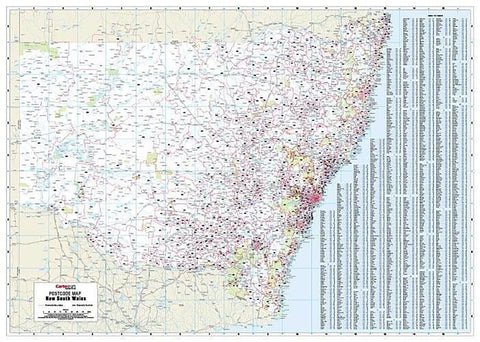
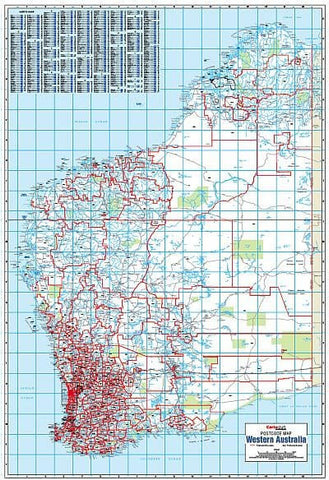
Each Australian state has a dedicated postcode wall map showing every postcode boundary across that state — ideal for businesses operating across regional and metro areas. Available for New South Wales, Victoria, Queensland, Western Australia, South Australia and Tasmania.
Metro Postcode Maps
Higher-detail postcode maps for the major Australian capitals — Sydney, Melbourne, Brisbane, Perth, Adelaide. These show every suburb and postcode in the metro area at sufficient resolution to identify individual streets and locality boundaries.
Regional Postcode Maps
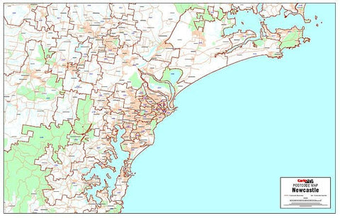
For specific high-population corridors and growth regions, dedicated postcode maps cover areas like the NSW Central Coast, Newcastle & the Hunter, Brisbane & the Gold Coast corridor, and the Sunshine Coast.
National & Folded Options
For travelling sales reps or smaller display formats, several states are also available as folded postcode maps — easier to store in glove boxes, briefcases or filing cabinets.
Custom & Branded Postcode Maps
Mapworld's most popular service for business customers is custom postcode mapping. We can produce maps with your own colour-coded sales territories, customer density overlays, branch or franchise boundaries, healthcare service areas, mining tenement layers, school catchment zones — anything that needs to be visualised at a postcode or council level. Maps can be branded with your logo, sized to fit a specific wall, and supplied laminated, rolled, or framed. Get in touch on 1300 795 697 to discuss a custom job.
Why Buy Postcode Maps from Mapworld
- Largest range in Australia — 17 in-stock postcode wall maps covering every state and major metro
- Current Australia Post boundaries — postcodes change as new suburbs develop; every map is the current edition at time of dispatch
- Laminated finish — write-on/wipe-off with whiteboard markers, ideal for ongoing sales and territory planning
- Custom branded service — sales territory overlays, customer density, franchise boundaries, healthcare catchments
- Same-day dispatch on weekday orders before 2 pm AWST. Free shipping over $75, flat $7 below
- 25+ years specialising in Australian maps — we know what real estate offices, sales teams and government planners actually need
Frequently Asked Questions
What is shown on a postcode wall map?
Each postcode boundary is outlined and labelled with the postcode number. Suburbs within each postcode are named and shown to their actual geographic boundaries. Major roads, rail lines and waterways are included for orientation, and most maps also show local government area (LGA) outlines as a secondary layer.
Are these the current postcode boundaries?
Yes. Australia Post updates postcode boundaries as new suburbs and developments come online. Mapworld stocks current editions and rotates stock as updates are published. Each product page lists the edition year.
What size postcode wall map should I buy?
For most office walls, the standard 788 × 1110mm laminated format is the right size — readable from across the room and fits behind a typical desk or in a meeting space. For larger sales floors, boardrooms or government offices, larger formats are available on request. For glove-box or small-office use, several states are also available as folded postcode maps.
Can I write on these maps?
Yes. All laminated postcode wall maps can be marked with whiteboard marker and wiped clean. This is by design — most postcode maps are bought specifically for territory planning, customer plotting, or service area definition where ongoing markup is the point.
Can I get a custom postcode map with my sales territories?
Yes. Mapworld runs a custom mapping service for businesses needing branded postcode maps with sales territories, franchise boundaries, customer density overlays, healthcare catchments, school zones and other business-specific layers. Call 1300 795 697 to discuss your requirements.
How fast is postcode map shipping?
Orders placed before 2 pm AWST on weekdays dispatch same-day from our Perth warehouse. Wall maps ship rolled in a tube via tracked courier. Most metro deliveries arrive in 2 to 5 business days. Free shipping on orders over $75; flat $7 below that.
For state-specific postcode coverage, the Victoria postcode wall map is the standard VIC reference for real estate and sales territory work.
For state-specific postcode coverage, the NSW postcode wall map is the standard NSW reference for real estate and sales territory work.
For state-specific postcode coverage, the Tasmania postcode wall map is the standard TAS reference for real estate and council work.
© 2026 Mapworld. Website designed by Genie Media
X