- Australia ▾
- Topographic
▾
- Australia AUSTopo 250k (2025)
- Australia 50k Geoscience maps
- Australia 100k Geoscience maps
- Australia 250k Geoscience maps
- Australia 1:1m Geoscience maps
- New Zealand 50k maps
- New Zealand 250k maps
- New South Wales 25k maps
- New South Wales 50k maps
- New South Wales 100k maps
- Queensland 10k maps
- Queensland 25k maps
- Queensland 50k maps
- Queensland 100k maps
- Western Australia 25k maps
- Western Australia 50k maps
- Western Australia 100k maps
- Compasses
- Software
- GPS Systems
- International ▾
- Wall Maps
▾
- World
- Australia & New Zealand
- Countries, Continents & Regions
- Historical
- Vintage National Geographic
- Australian Capital Territory
- New South Wales
- Northern Territory
- Queensland
- South Australia
- Tasmania
- Victoria
- Western Australia
- Celestial
- Children's
- Mining & Resources
- Wine Maps
- Healthcare
- Postcode Maps
- Electoral Maps
- Nautical ▾
- Flags
▾
- Australian Flag Sets & Banners
- Flag Bunting
- Handwavers
- Australian National Flags
- Aboriginal Flags
- Torres Strait Islander Flags
- International Flags
- Flagpoles & Accessories
- Australian Capital Territory Flags
- New South Wales Flags
- Northern Territory Flags
- Queensland Flags
- South Australia Flags
- Tasmania Flags
- Victoria Flags
- Western Australia Flags
- Gifts ▾
- Globes ▾
Dear valued customer. Please note that our checkout is not supported by old browsers. Please use a recent browser to access all checkout capabilities


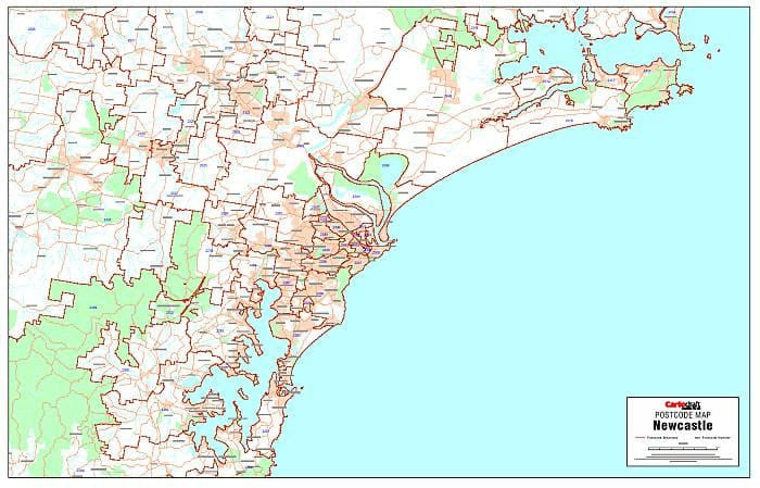
Newcastle Postcode Laminated Wall Map 1120 x 722mm
$109.95
or make 4 interest-free payments of
$27.49 AUD
fortnightly with
![]() More info
More info
Newcastle Postcode Laminated Wall Map · 1120 × 722 mm
The complete postcode planning map for Newcastle and surrounds—designed to meet the demands of sales teams, service providers, and logistics managers. Cartodraft’s Newcastle Postcode Map brings together postcode boundaries and numbers in one clear, wall-sized view, finished with a tough write-on/wipe-off laminate so you can plan, mark, and refine with ease.
✅ Why this map is essential
-
🗺️ Comprehensive postcode clarity — every boundary and number presented with precision
-
📇 Fast suburb verification — check codes instantly for quoting, dispatch, and planning
-
✍️ True write & wipe surface — annotate territories, delivery runs, and KPIs with whiteboard markers; erase without ghosting
-
🎯 Dot-mapping ready — use Mark-It-Dots to highlight customer clusters, depots, or service zones without damaging the surface
-
🏢 Made for operations — perfect for team hubs, boardrooms, reception areas, and control centres
🪵 Premium materials (built to last)
This is more than a map—it’s a professional-grade planning tool, engineered for durability:
-
Heavy base stock — high-quality paper base for sharp detail and strong colour reproduction
-
Encapsulation lamination — sealed in 2 × 80-micron gloss film, edge-to-edge, for waterproofing and tear resistance
-
Write-on/wipe-off finish — designed for daily use with whiteboard markers; erase cleanly every time
-
Edge-sealed protection — prevents peeling and protects against moisture in busy environments
-
Colour-managed printing — consistent, high-contrast tones for clear wall readability
✨ Optional professional display: Laminated + Timber Hang Rails — lacquered natural timber rails fitted top & bottom with a hanging cord.
⏱️ Please allow up to 10 working days for hang-railed maps.
🧾 What’s on the map
-
Newcastle metro and surrounds — postcode boundaries & numbers clearly shown
-
Suburb/postcode layout for fast confirmation
-
Major roads & corridors (as supplied by Cartodraft) for easy orientation
📐 Size & display
-
1120 × 722 mm (landscape) — wide format, designed to command attention in meeting rooms and operations hubs
-
Mount using 3M picture strips, screws, or upgrade to timber hang rails for a professional presentation
📦 Business use cases
-
Sales & franchise territories — divide, assign, and adjust rep zones
-
Courier & delivery runs — visualise coverage, balance workloads, and refine routes
-
Service teams — mark out maintenance areas, contracts, or call zones
-
Customer density analysis — identify hotspots, clusters, and growth opportunities
-
Event & outreach planning — coordinate campaigns and community activities by postcode
🧽 Care & handling
-
Clean gently with a soft dry or slightly damp cloth
-
Use only quality whiteboard markers (avoid permanent/ethanol-based inks)
-
Remove adhesive dots or tape carefully to preserve the edge seal
📊 Specifications
| Field | Detail |
|---|---|
| Title | Newcastle Postcode Laminated Wall Map |
| Publisher | Cartodraft |
| Coverage | Newcastle & surrounds — postcode boundaries & numbers |
| Index | Suburb/postcode layout for reference |
| Colour-managed, high-contrast cartography | |
| Lamination | 2 × 80-micron gloss film, fully encapsulated, edge-sealed |
| Surface | Write-on/wipe-off (whiteboard-marker compatible) |
| Size & Orientation | Landscape — 1120 × 722 mm |
| Optional Display | Laminated + Timber Hang Rails (natural lacquered; allow up to 10 working days) |
| Best for | Sales, logistics, franchise planning, service coverage, hotspot analysis |
🇦🇺 Our commitment
-
Made & printed in Australia — supporting local expertise and production
-
Colour-managed workflow — every map checked for sharpness, tone, and accuracy
-
Hand-finished lamination — edges sealed smooth for long life
-
Packed with care — shipped in protective tubes or flat-packed for safe delivery
-
Family-run knowledge — decades of mapping expertise at your service
See Newcastle at postcode level. Select your finish and bring this professional planning tool into your workspace today.
Frequently Asked Questions
What are the dimensions of the Newcastle Postcode Laminated Wall Map 1120 x 722mm?
Mapworld wall maps range from standard 700×1000mm to large-format 1000×1430mm Supermaps. The exact dimensions for this map are shown in the product title. Where multiple sizes are available, select your preferred size when adding to cart.
Is this wall map available laminated?
Many Mapworld wall maps are available in paper, laminated, or framed finishes. Check the product options when adding to cart. Laminated maps are wipe-clean and more durable.
Is this the latest edition?
Mapworld stocks the most current editions available from all publishers. Edition year is shown in the product title where applicable. Mapworld updates its catalogue as new editions are released.
Can I write on or pin this wall map?
Laminated wall maps can be written on with whiteboard markers and wiped clean. Paper maps can be pinned on a corkboard. Choose a laminated option for a writeable surface.
Does Mapworld ship the Newcastle Postcode Laminated Wall Map 1120 x 722mm across Australia?
Yes, Mapworld ships Australia-wide. Standard shipping is a flat $7 rate, with free standard shipping on orders over $75. Express options are available at checkout. Most orders placed before 2pm AEST on weekdays are dispatched same day.
Related Items


© 2026 Mapworld. Website designed by Genie Media
X