- Australia ▾
- Topographic
▾
- Australia AUSTopo 250k (2025)
- Australia 50k Geoscience maps
- Australia 100k Geoscience maps
- Australia 250k Geoscience maps
- Australia 1:1m Geoscience maps
- New Zealand 50k maps
- New Zealand 250k maps
- New South Wales 25k maps
- New South Wales 50k maps
- New South Wales 100k maps
- Queensland 10k maps
- Queensland 25k maps
- Queensland 50k maps
- Queensland 100k maps
- Compasses
- Software
- GPS Systems
- Orienteering
- International ▾
- Wall Maps
▾
- World
- Australia & New Zealand
- Countries, Continents & Regions
- Historical
- Vintage National Geographic
- Australian Capital Territory
- New South Wales
- Northern Territory
- Queensland
- South Australia
- Tasmania
- Victoria
- Western Australia
- Celestial
- Children's
- Mining & Resources
- Wine Maps
- Healthcare
- Postcode Maps
- Electoral Maps
- Nautical ▾
- Flags
▾
- Australian Flag Sets & Banners
- Flag Bunting
- Handwavers
- Australian National Flags
- Aboriginal Flags
- Torres Strait Islander Flags
- International Flags
- Flagpoles & Accessories
- Australian Capital Territory Flags
- New South Wales Flags
- Northern Territory Flags
- Queensland Flags
- South Australia Flags
- Tasmania Flags
- Victoria Flags
- Western Australia Flags
- Gifts ▾
- Globes ▾
Dear valued customer. Please note that our checkout is not supported by old browsers. Please use a recent browser to access all checkout capabilities


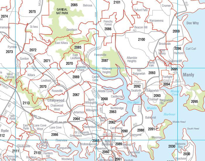
New South Wales Postcode Laminated Wall Map 1110 x 788mm
$109.95
or make 4 interest-free payments of
$27.49 AUD
fortnightly with
![]() More info
More info
New South Wales Postcode Laminated Wall Map · 1110 × 788 mm
The comprehensive postcode planning map for NSW—built for clarity, durability, and professional use. Cartodraft’s New South Wales Postcode Map shows every postcode boundary and number across the state, from Sydney’s dense metro zones to the Illawarra, Hunter, Riverina, Central West, North Coast, and remote western regions. Finished in a robust write-on/wipe-off laminate, it’s the perfect wall map for organisations managing logistics, sales territories, service coverage, or government planning across Australia’s most populous state.
✅ Why this map is indispensable
-
Complete statewide coverage — the only single-sheet map that combines Sydney, regional, and rural postcodes into one clear view
-
Comprehensive suburb & town index — quickly cross-reference thousands of localities with their postcode numbers
-
True write & wipe surface — annotate directly with whiteboard markers; erase cleanly without ghosting or residue
-
Dot-mapping ready — highlight depots, franchise areas, or customer hotspots with Mark-It-Dots without damaging the surface
-
Professional-grade clarity — designed for business, government, and education, with strong contrast for room-distance readability
-
Multi-purpose utility — whether for logistics hubs, boardrooms, classrooms, or reception walls, this map delivers practical value
🪵 Premium materials (engineered for longevity)
-
Heavy base stock — bright, smooth paper ensures crisp type and vibrant colour
-
Encapsulation lamination — sealed edge-to-edge in 2 × 80-micron gloss film, waterproof and tear-resistant
-
Reusable write-on/wipe-off finish — reliable for daily use with standard whiteboard markers
-
Edge-sealed durability — prevents fraying and resists moisture in high-use settings
-
Colour-managed printing — bold tones and fine linework make every boundary and number easy to read
✨ Optional upgrade: Laminated + Timber Hang Rails — lacquered natural timber rails fitted top & bottom with a hanging cord for an elegant, professional presentation.
⏱️ Please allow up to 10 working days for hang-railed maps.
🧾 What’s on the map
-
Postcode boundaries & numbers for all of New South Wales, metro to outback
-
Comprehensive town & suburb index for postcode lookups at a glance
-
Major highways, corridors, and reference features (as supplied by Cartodraft)
📐 Size & display
-
1110 × 788 mm (landscape) — wide format that balances detail with wall efficiency
-
Sized to suit boardrooms, dispatch hubs, and classrooms
-
Easy to mount with 3M picture strips or screws, or upgrade to timber rails for a ready-to-hang solution
📦 Common business & professional uses
-
Sales & franchise territory planning — allocate, manage, and adjust catchments across metro and regional NSW
-
Logistics & courier operations — plan delivery runs, last-mile routing, and regional distribution networks
-
Government & administration — vital for outreach, compliance, electoral planning, and public services
-
Education & training — valuable teaching resource for geography, planning, and business studies
-
Professional display — impress clients and staff with a functional, information-rich wall feature
🧽 Care & handling
-
Clean gently with a soft dry or slightly damp cloth
-
Use only whiteboard markers (avoid permanent/ethanol-based pens)
-
Remove adhesive dots or tape carefully to protect the laminate seal
📊 Specifications
| Field | Detail |
|---|---|
| Title | New South Wales Postcode Laminated Wall Map |
| Publisher | Cartodraft |
| Coverage | NSW — statewide postcode boundaries & numbers |
| Index | Comprehensive suburb & town index with postcodes |
| Colour-managed, high-contrast cartography | |
| Lamination | 2 × 80-micron gloss film, fully encapsulated, edge-sealed |
| Surface | Write-on/wipe-off (whiteboard-marker compatible) |
| Size & Orientation | Landscape — 1110 × 788 mm |
| Optional Display | Laminated + Timber Hang Rails (natural lacquered; allow up to 10 working days) |
| Best for | Sales, logistics, franchise planning, government services, education |
🇦🇺 Our commitment
-
Made & printed in Australia — proudly produced with local expertise
-
Hand-finished lamination — carefully sealed for strength and smoothness
-
Colour-managed printing — ensuring sharp, consistent clarity in every run
-
Careful packaging — shipped in protective tubes or flat-packed to arrive safe and ready
-
Family-run knowledge — decades of mapmaking experience embedded into every product
Plan New South Wales with confidence. Select your finish, add accessories, and bring statewide postcode clarity to your wall today.
Frequently Asked Questions
What are the dimensions of the New South Wales Postcode Laminated Wall Map 1110 x 788mm?
Mapworld wall maps range from standard 700×1000mm to large-format 1000×1430mm Supermaps. The exact dimensions for this map are shown in the product title. Where multiple sizes are available, select your preferred size when adding to cart.
Is this wall map available laminated?
Many Mapworld wall maps are available in paper, laminated, or framed finishes. Check the product options when adding to cart. Laminated maps are wipe-clean and more durable.
Is this the latest edition?
Mapworld stocks the most current editions available from all publishers. Edition year is shown in the product title where applicable. Mapworld updates its catalogue as new editions are released.
Can I write on or pin this wall map?
Laminated wall maps can be written on with whiteboard markers and wiped clean. Paper maps can be pinned on a corkboard. Choose a laminated option for a writeable surface.
Does Mapworld ship the New South Wales Postcode Laminated Wall Map 1110 x 788mm across Australia?
Yes, Mapworld ships Australia-wide. Standard shipping is a flat $7 rate, with free standard shipping on orders over $75. Express options are available at checkout. Most orders placed before 2pm AEST on weekdays are dispatched same day.
Related Items


© 2026 Mapworld. Website designed by Genie Media
X