- Australia ▾
- Topographic
▾
- Australia AUSTopo 250k (2025)
- Australia 50k Geoscience maps
- Australia 100k Geoscience maps
- Australia 250k Geoscience maps
- Australia 1:1m Geoscience maps
- New Zealand 50k maps
- New Zealand 250k maps
- New South Wales 25k maps
- New South Wales 50k maps
- New South Wales 100k maps
- Queensland 10k maps
- Queensland 25k maps
- Queensland 50k maps
- Queensland 100k maps
- Western Australia 25k maps
- Western Australia 50k maps
- Western Australia 100k maps
- Compasses
- Software
- GPS Systems
- International ▾
- Wall Maps
▾
- World
- Australia & New Zealand
- Countries, Continents & Regions
- Historical
- Vintage National Geographic
- Australian Capital Territory
- New South Wales
- Northern Territory
- Queensland
- South Australia
- Tasmania
- Victoria
- Western Australia
- Celestial
- Children's
- Mining & Resources
- Wine Maps
- Healthcare
- Postcode Maps
- Electoral Maps
- Nautical ▾
- Flags
▾
- Australian Flag Sets & Banners
- Flag Bunting
- Handwavers
- Australian National Flags
- Aboriginal Flags
- Torres Strait Islander Flags
- International Flags
- Flagpoles & Accessories
- Australian Capital Territory Flags
- New South Wales Flags
- Northern Territory Flags
- Queensland Flags
- South Australia Flags
- Tasmania Flags
- Victoria Flags
- Western Australia Flags
- Gifts ▾
- Globes ▾
Dear valued customer. Please note that our checkout is not supported by old browsers. Please use a recent browser to access all checkout capabilities


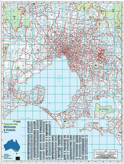

Melbourne & Victoria Postcode Laminated Wall Map 788 x 1036mm
$109.95
or make 4 interest-free payments of
$27.49 AUD
fortnightly with
![]() More info
More info
Melbourne & Victoria Postcode Laminated Wall Map · 788 × 1036 mm
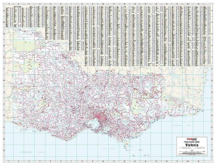
The definitive postcode planning map for Victoria and its capital city, Melbourne. Cartodraft’s Melbourne & Victoria Postcode Map combines complete state coverage with detailed metropolitan clarity. Every postcode boundary and number is presented—whether you’re looking at the dense network of Melbourne’s suburbs or the far reaches of Gippsland, the Murray River, the Western District, or Mildura. Finished in a robust write-on/wipe-off laminate, this map is designed to meet the needs of sales teams, logistics operators, service planners, government agencies, and educators who rely on postcode accuracy every day.
✅ Why this map is indispensable
-
Dual focus clarity — Melbourne’s complex suburban postcode network plus statewide Victoria coverage on one sheet
-
Comprehensive suburb & town index — instant postcode lookup without external references
-
True write & wipe finish — annotate delivery runs, sales territories, or service areas with whiteboard markers and erase cleanly
-
Dot-mapping ready — Mark-It-Dots compatible for easy highlighting of depots, customers, or franchise zones
-
Professional-grade readability — high-contrast cartography ensures boundaries and labels are legible from wall distance
-
Trusted by professionals — widely used by logistics companies, franchise managers, planners, government staff, and schools
🪵 Premium materials (engineered for durability)
This is not a flimsy poster—it’s a long-lasting, professional planning tool:
-
Heavyweight base stock — smooth, bright paper guarantees crisp text and colour fidelity
-
True encapsulation lamination — sealed edge-to-edge in 2 × 80-micron gloss film, waterproof and tear-resistant
-
Reusable write-on/wipe-off surface — withstands heavy use with standard whiteboard markers
-
Edge-sealed protection — prevents peeling, fraying, and moisture ingress
-
Colour-managed printing — consistent tones and bold contrast deliver maximum clarity
✨ Optional upgrade: Laminated + Timber Hang Rails — lacquered natural timber rails fitted top & bottom with a hanging cord for a clean, ready-to-hang finish.
⏱️ Please allow up to 10 working days for hang-railed maps.
🧾 What’s on the map
-
Victoria postcode boundaries & numbers across every metro, regional, and rural zone
-
Detailed Melbourne metro coverage — all suburbs clearly marked with postcode divisions
-
Comprehensive suburb & town index for postcode cross-referencing
-
Major highways, arterial roads, and reference features (as supplied by Cartodraft)
📐 Size & display
-
788 × 1036 mm (portrait) — large enough for statewide clarity, compact enough for most walls
-
Perfect for operations centres, classrooms, boardrooms, and logistics hubs
-
Easy to mount with 3M picture strips, screws, or upgrade to timber rails for a polished professional finish
📦 Common professional uses
-
Sales & franchise territory planning — design, review, and manage postcode-based territories across metro and regional Victoria
-
Logistics & courier services — plan delivery runs, warehousing, and distribution networks with postcode accuracy
-
Government & administration — essential for electoral planning, outreach programs, and community service mapping
-
Education & training — practical teaching tool for geography, business, and planning studies
-
Professional display — doubles as a functional planning aid and an authoritative wall feature
🧽 Care & handling
-
Clean gently with a soft dry or slightly damp cloth
-
Use only whiteboard markers (avoid permanent or ethanol-based pens)
-
Remove adhesive dots or tape carefully to preserve the laminate seal
📊 Specifications
| Field | Detail |
|---|---|
| Title | Melbourne & Victoria Postcode Laminated Wall Map |
| Publisher | Cartodraft |
| Coverage | Victoria statewide with detailed Melbourne metro |
| Index | Comprehensive suburb & town index with postcodes |
| Colour-managed, high-contrast cartography | |
| Lamination | 2 × 80-micron gloss film, fully encapsulated, edge-sealed |
| Surface | Write-on/wipe-off (whiteboard-marker compatible) |
| Orientation & Size | Portrait — 788 × 1036 mm |
| Optional Display | Laminated + Timber Hang Rails (natural lacquered; allow up to 10 working days) |
| Best for | Sales, logistics, government planning, service coverage, education |
🇦🇺 Our commitment
-
Made & printed in Australia — supporting local expertise and production
-
Hand-finished lamination — every map sealed smooth for strength and long life
-
Colour-managed workflow — ensuring clarity and accuracy across every print run
-
Carefully packaged — shipped rolled or flat for safe arrival
-
Family-run business — decades of mapping expertise embedded into every product
Plan Melbourne and Victoria with precision. Select your finish, add accessories, and bring this professional postcode wall map to your office, classroom, or planning hub today.
Frequently Asked Questions
What are the dimensions of the Melbourne & Victoria Postcode Laminated Wall Map 788 x 1036mm?
Mapworld wall maps range from standard 700×1000mm to large-format 1000×1430mm Supermaps. The exact dimensions for this map are shown in the product title. Where multiple sizes are available, select your preferred size when adding to cart.
Is this wall map available laminated?
Many Mapworld wall maps are available in paper, laminated, or framed finishes. Check the product options when adding to cart. Laminated maps are wipe-clean and more durable.
Is this the latest edition?
Mapworld stocks the most current editions available from all publishers. Edition year is shown in the product title where applicable. Mapworld updates its catalogue as new editions are released.
Can I write on or pin this wall map?
Laminated wall maps can be written on with whiteboard markers and wiped clean. Paper maps can be pinned on a corkboard. Choose a laminated option for a writeable surface.
Does Mapworld ship the Melbourne & Victoria Postcode Laminated Wall Map 788 x 1036mm across Australia?
Yes, Mapworld ships Australia-wide. Standard shipping is a flat $7 rate, with free standard shipping on orders over $75. Express options are available at checkout. Most orders placed before 2pm AEST on weekdays are dispatched same day.
Related Items


© 2026 Mapworld. Website designed by Genie Media
X