- Australia ▾
- Topographic
▾
- Australia AUSTopo 250k (2025)
- Australia 50k Geoscience maps
- Australia 100k Geoscience maps
- Australia 250k Geoscience maps
- Australia 1:1m Geoscience maps
- New Zealand 50k maps
- New Zealand 250k maps
- New South Wales 25k maps
- New South Wales 50k maps
- New South Wales 100k maps
- Queensland 10k maps
- Queensland 25k maps
- Queensland 50k maps
- Queensland 100k maps
- Western Australia 25k maps
- Western Australia 50k maps
- Western Australia 100k maps
- Compasses
- Software
- GPS Systems
- International ▾
- Wall Maps
▾
- World
- Australia & New Zealand
- Countries, Continents & Regions
- Historical
- Vintage National Geographic
- Australian Capital Territory
- New South Wales
- Northern Territory
- Queensland
- South Australia
- Tasmania
- Victoria
- Western Australia
- Celestial
- Children's
- Mining & Resources
- Wine Maps
- Healthcare
- Postcode Maps
- Electoral Maps
- Nautical ▾
- Flags
▾
- Australian Flag Sets & Banners
- Flag Bunting
- Handwavers
- Australian National Flags
- Aboriginal Flags
- Torres Strait Islander Flags
- International Flags
- Flagpoles & Accessories
- Australian Capital Territory Flags
- New South Wales Flags
- Northern Territory Flags
- Queensland Flags
- South Australia Flags
- Tasmania Flags
- Victoria Flags
- Western Australia Flags
- Gifts ▾
- Globes ▾
Dear valued customer. Please note that our checkout is not supported by old browsers. Please use a recent browser to access all checkout capabilities


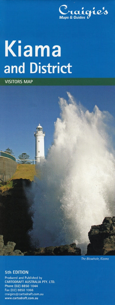
Kiama & District Craigies Map
$14.95
Afterpay is only available for orders between $50.00 and $1000.00 More info
Kiama & District Map – Craigies Premium Edition
Your ultimate guide to the scenic Illawarra and South Coast hinterland – from surf beaches to rolling countryside
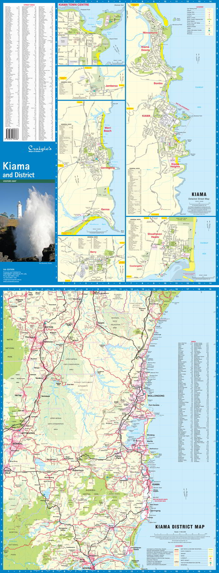
The Kiama & District Map by Craigies is a meticulously detailed and professionally designed regional and street map that captures the charm, variety, and topographical features of one of New South Wales’ most loved regions. From the rugged cliffs of Kiama’s Blowhole to the pastoral calm of Berry and the laid-back surf towns of Gerroa and Gerringong, this map offers clear, easy-to-follow cartography tailored for explorers, locals, tourists, and professionals alike.
Whether you're cruising the Grand Pacific Drive, navigating regional routes between villages, or searching for a boutique café, lookout, or rest stop—this map delivers clarity, coverage, and confidence.
🌄 Regional Coverage
This map encompasses a generous corridor of the Illawarra and Shoalhaven coast, including both seaside destinations and elevated hinterland terrain:
-
Northern Limit: Helensburgh – gateway to the Royal National Park
-
Southern Limit: Nowra – a vibrant river town and hub for Shoalhaven tourism
-
Western Limit: Moss Vale and the Southern Highlands – cool-climate charm and country drives
It’s ideal for those journeying between the South Coast and the Highlands, giving a full overview of road networks, scenic detours, and natural landmarks.
🏙️ Detailed Street Mapping
Zoomed-in street-level mapping is included for:
-
Kiama – home of the iconic Blowhole, Surf Beach & Bombo Quarry
-
Berry – beloved for boutique shopping, historic charm & weekend escapes
-
Gerringong & Gerroa – coastal towns with panoramic ocean views and surfing beaches
-
Shoalhaven Heads & Coolangatta – tranquil riverside communities near wineries and beaches
-
Minnamurra & Kiama Downs – family-friendly suburbs with beaches and bushland reserves
-
Jamberoo – hinterland village surrounded by lush hills and country roads
-
Werri Beach, Bombo, Kiama Heights – popular coastal strips and lookout points
Each street map includes named streets, local amenities, tourist icons, and key facilities to support both trip planning and everyday navigation.
📐 Scales & Map Specifications
| Map Type | Coverage Area | Scale |
|---|---|---|
| District Map | Helensburgh to Nowra, incl. Berry & Moss Vale | 1:160,000 |
| Street Maps | Individual towns & coastal villages | 1:26,000 |
-
Printed Area: Large-format fold-out size
-
Design: Colour-coded with easy-to-read legends, road classification symbols, and natural feature shading
-
Format: Folded paper map, perfect for glove boxes, backpacks, or use at home
🧭 Key Features & Highlights
✅ Up-to-date road networks, including highways, local roads, and tourist routes
✅ National parks, state forests, beaches, rivers, and elevation shading
✅ Tourist attractions clearly marked – including the Kiama Blowhole, Boneyard, Cathedral Rocks, Seven Mile Beach, and more
✅ Walking tracks, lookouts, picnic areas, schools, shopping zones, and sporting grounds
✅ Town facilities such as hospitals, information centres, wineries, caravan parks, and campgrounds
✅ Distance indicators and direction markers to assist in travel planning
🎯 Who Is This Map For?
-
🧳 Tourists & Weekend Travellers: Discover hidden beach spots, scenic drives, and the best picnic spots
-
🗺️ Locals: Keep a reliable, big-picture reference of your region on hand
-
🚐 Caravanners & Road Trippers: Identify rest stops, fuel points, and overnight options
-
🏡 Real Estate Professionals & Planners: Use for property location and service area planning
-
🚛 Service Providers: Deliveries, trades, and transport businesses needing local street references
-
🧒 Educators & Students: A rich resource for classroom learning or school projects
-
🏞️ Outdoor Enthusiasts: Ideal for walkers, cyclists, photographers, and nature lovers exploring inland and coastal trails
📌 Why Choose Craigies Maps?
Craigies has built a reputation for highly accurate, locally verified maps that serve both recreational users and professional industries. Every map is crafted to be:
-
Clear and visually accessible, with user-friendly layouts
-
Comprehensive in detail, without being cluttered
-
Designed for real-world use, balancing navigational utility with regional discovery
-
Updated regularly to reflect recent roadworks, town expansions, and infrastructure changes
🗺️ Summary
From sea to summit, the Kiama & District Craigies Map is your trusted travel companion for discovering one of New South Wales’ most picturesque and diverse regions. Whether you're relaxing in a coastal village, climbing a rainforest trail, or planning a new service zone, this map delivers essential guidance in a compact, easy-to-use format.
Explore more. Discover confidently. Navigate with Craigies
Frequently Asked Questions
Where can I buy the Kiama & District Craigies Map?
The Kiama & District Craigies Map is available to buy online from Mapworld, Australia's largest map and geographic product retailer, with fast shipping Australia-wide.
Is the Kiama & District Craigies Map in stock at Mapworld?
Mapworld maintains extensive stock across its map range and aims for fast dispatch. Orders placed before 2pm AEST on business days are typically dispatched the same day, with standard and express Australia-wide delivery options available.
What is Mapworld's returns policy?
Mapworld accepts returns on undamaged items in original condition. Contact Mapworld within 90 days of purchase to arrange a return or exchange.
Does Mapworld ship the Kiama & District Craigies Map across Australia?
Yes, Mapworld ships Australia-wide. Standard shipping is a flat $7 rate, with free standard shipping on orders over $75. Express options are available at checkout. Most orders placed before 2pm AEST on weekdays are dispatched same day.
Related Items


© 2026 Mapworld. Website designed by Genie Media
X