- Australia ▾
- Topographic
▾
- Australia AUSTopo 250k (2025)
- Australia 50k Geoscience maps
- Australia 100k Geoscience maps
- Australia 250k Geoscience maps
- Australia 1:1m Geoscience maps
- New Zealand 50k maps
- New Zealand 250k maps
- New South Wales 25k maps
- New South Wales 50k maps
- New South Wales 100k maps
- Queensland 10k maps
- Queensland 25k maps
- Queensland 50k maps
- Queensland 100k maps
- Western Australia 25k maps
- Western Australia 50k maps
- Western Australia 100k maps
- Compasses
- Software
- GPS Systems
- International ▾
- Wall Maps
▾
- World
- Australia & New Zealand
- Countries, Continents & Regions
- Historical
- Vintage National Geographic
- Australian Capital Territory
- New South Wales
- Northern Territory
- Queensland
- South Australia
- Tasmania
- Victoria
- Western Australia
- Celestial
- Children's
- Mining & Resources
- Wine Maps
- Healthcare
- Postcode Maps
- Electoral Maps
- Nautical ▾
- Flags
▾
- Australian Flag Sets & Banners
- Flag Bunting
- Handwavers
- Australian National Flags
- Aboriginal Flags
- Torres Strait Islander Flags
- International Flags
- Flagpoles & Accessories
- Australian Capital Territory Flags
- New South Wales Flags
- Northern Territory Flags
- Queensland Flags
- South Australia Flags
- Tasmania Flags
- Victoria Flags
- Western Australia Flags
- Gifts ▾
- Globes ▾
Dear valued customer. Please note that our checkout is not supported by old browsers. Please use a recent browser to access all checkout capabilities


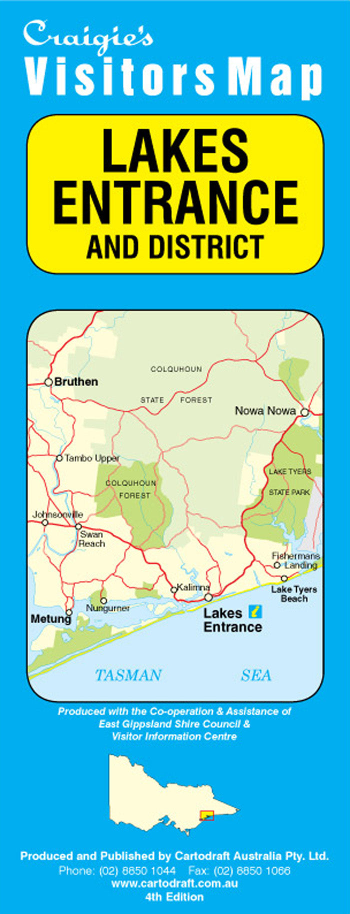
Lakes Entrance & District Craigies Map
$14.95
Afterpay is only available for orders between $50.00 and $1000.00 More info
Lakes Entrance & District Map – Craigies Premium Edition
Your essential map for discovering the waterways, forests, and towns of Victoria’s East Gippsland coast
The Lakes Entrance & District Map by Craigies is a beautifully detailed and professionally designed regional map that captures the stunning diversity of the Gippsland Lakes region. Ideal for locals, visitors, adventurers, and service providers, this map covers one of Victoria’s most scenic and ecologically rich coastal areas — where inland waterways, ocean beaches, national parks, and charming towns converge.
Whether you’re cruising through the lakes, planning a beachside holiday, scouting a camping spot, or servicing local communities, this map provides the clarity and coverage you need.
🌏 Coverage Area
This map spans a wide and varied area of East Gippsland, extending:
-
North to Bruthen – gateway to the high country and Tambo River valley
-
South to Loch Sport – a coastal town on the shores of Lake Victoria
-
East to Nowa Nowa – nestled near Lake Tyers State Park
-
West to Meerlieu – on the eastern edge of the Gippsland Plains
This ensures coverage of key touring routes, lake systems, and recreational zones across the broader district.
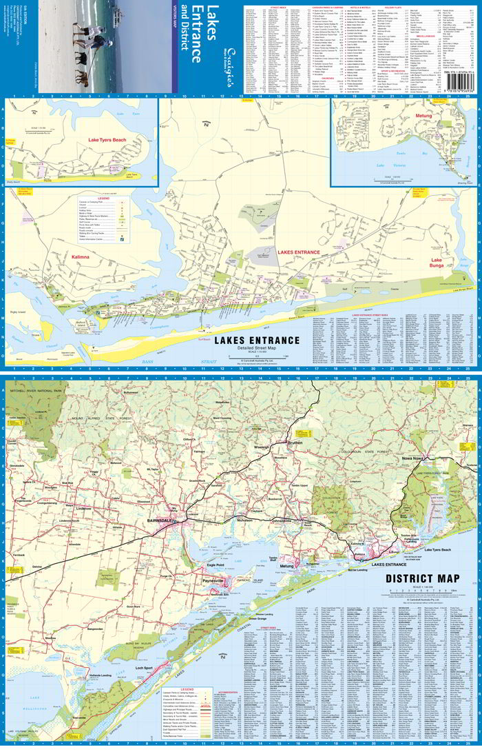
🏙️ Detailed Street Mapping
Zoomed-in street-level maps are included for the region’s key townships:
-
Lakes Entrance – the major tourist hub with access to 90 Mile Beach and Gippsland Lakes
-
Lake Tyers Beach – popular for fishing, boating, and peaceful bushland stays
-
Metung – a stylish lakeside village with marinas, cafes, and waterfront trails
-
Bruthen – a historic town on the Great Alpine Road with access to rail trails and rivers
Each street map includes named roads, facilities, parks, boat ramps, walking tracks, and landmarks — perfect for trip planning or day-to-day navigation.
📐 Map Scales & Specifications
| Map Type | Area Covered | Scale |
|---|---|---|
| District Map | Bruthen to Loch Sport, Nowa Nowa to Meerlieu | 1:140,000 |
| Street Maps | Lakes Entrance, Metung, Bruthen, Lake Tyers Beach | 1:15,000 |
-
Format: Folded paper map
-
Design: Clear, colour-coded layout with symbols for natural features, services, and tourist spots
-
Size: Large-format for ease of reading, ideal for glovebox, backpack, or wall use
🧭 Key Features
✅ Major and minor roads, local routes, and touring corridors
✅ National parks and reserves including Gippsland Lakes Coastal Park & Lake Tyers State Park
✅ Walking trails, boat ramps, beaches, and fishing locations
✅ Caravan parks, camping areas, visitor centres, and lookouts
✅ Key services such as hospitals, fuel stations, schools, and recreation grounds
✅ Waterways including Lake Victoria, Lake King, Lake Tyers, and the Tambo & Mitchell Rivers
✅ Heritage and tourist icons to highlight points of interest
🎯 Ideal For
-
🧳 Tourists & Holidaymakers: Explore the region’s towns, lakes, beaches, and scenic drives
-
🏕️ Campers & Boaters: Navigate from site to site, from jetty to jetty
-
🚐 Caravanners: Plan road trips, refuelling, and overnight stays with ease
-
🛠️ Service & Delivery Professionals: Pinpoint addresses and service zones
-
🏞️ Walkers & Nature Lovers: Discover hidden trails, forests, and wetland reserves
-
🧭 Locals & New Residents: Get a big-picture overview of the region and its connections
📌 Why Choose Craigies Maps?
Craigies is a trusted name in Australian mapping, renowned for:
-
Up-to-date local cartography
-
Accurate, real-world road data
-
Readable designs and clear street labelling
-
Tourist-friendly features and regional insights
Whether you’re cruising along the Princes Highway, paddling through the backwaters of Lake Tyers, or relaxing in Metung, the Lakes Entrance & District Craigies Map helps you experience East Gippsland with confidence and ease.
Explore more. Plan smarter. Travel better — with Craigies
Frequently Asked Questions
Where can I buy the Lakes Entrance & District Craigies Map?
The Lakes Entrance & District Craigies Map is available to buy online from Mapworld, Australia's largest map and geographic product retailer, with fast shipping Australia-wide.
Is the Lakes Entrance & District Craigies Map in stock at Mapworld?
Mapworld maintains extensive stock across its map range and aims for fast dispatch. Orders placed before 2pm AEST on business days are typically dispatched the same day, with standard and express Australia-wide delivery options available.
What is Mapworld's returns policy?
Mapworld accepts returns on undamaged items in original condition. Contact Mapworld within 90 days of purchase to arrange a return or exchange.
Does Mapworld ship the Lakes Entrance & District Craigies Map across Australia?
Yes, Mapworld ships Australia-wide. Standard shipping is a flat $7 rate, with free standard shipping on orders over $75. Express options are available at checkout. Most orders placed before 2pm AEST on weekdays are dispatched same day.
Related Items


© 2026 Mapworld. Website designed by Genie Media
X