- Australia ▾
- Topographic
▾
- Australia AUSTopo 250k (2025)
- Australia 50k Geoscience maps
- Australia 100k Geoscience maps
- Australia 250k Geoscience maps
- Australia 1:1m Geoscience maps
- New Zealand 50k maps
- New Zealand 250k maps
- New South Wales 25k maps
- New South Wales 50k maps
- New South Wales 100k maps
- Queensland 10k maps
- Queensland 25k maps
- Queensland 50k maps
- Queensland 100k maps
- Western Australia 25k maps
- Western Australia 50k maps
- Western Australia 100k maps
- Compasses
- Software
- GPS Systems
- International ▾
- Wall Maps
▾
- World
- Australia & New Zealand
- Countries, Continents & Regions
- Historical
- Vintage National Geographic
- Australian Capital Territory
- New South Wales
- Northern Territory
- Queensland
- South Australia
- Tasmania
- Victoria
- Western Australia
- Celestial
- Children's
- Mining & Resources
- Wine Maps
- Healthcare
- Postcode Maps
- Electoral Maps
- Nautical ▾
- Flags
▾
- Australian Flag Sets & Banners
- Flag Bunting
- Handwavers
- Australian National Flags
- Aboriginal Flags
- Torres Strait Islander Flags
- International Flags
- Flagpoles & Accessories
- Australian Capital Territory Flags
- New South Wales Flags
- Northern Territory Flags
- Queensland Flags
- South Australia Flags
- Tasmania Flags
- Victoria Flags
- Western Australia Flags
- Gifts ▾
- Globes ▾
Dear valued customer. Please note that our checkout is not supported by old browsers. Please use a recent browser to access all checkout capabilities


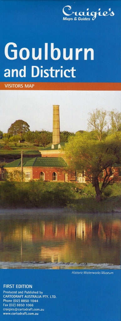
Goulburn & District Craigies Map
$14.95
Afterpay is only available for orders between $50.00 and $1000.00 More info
Goulburn & District Map by Craigies
Your essential navigation companion for exploring Goulburn and the heart of the Southern Tablelands
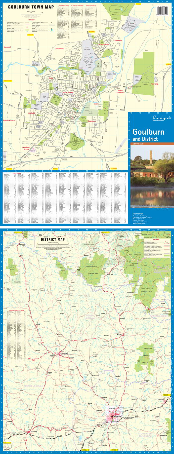
The Craigies Goulburn & District Map is a comprehensive and easy-to-read map that captures both the urban detail of Goulburn and the broader rural surroundings of this historic region. Ideal for locals, travellers, and businesses alike, this map provides accurate street-level navigation along with a regional overview to help you explore with clarity and confidence.
📍 Coverage Area
The district map stretches across a broad portion of the Southern Tablelands, encompassing key natural and rural landmarks:
-
North to Kanangra Tops
-
South to Gunning
-
East to Hanworth
-
West to Crooked Corner
This expanded coverage makes it perfect not only for navigating within the city of Goulburn but also for road-tripping through the picturesque countryside and nearby villages.
🏙️ Detailed Street Maps
In addition to the district map, this publication includes detailed street-level maps of Goulburn and its surrounding localities:
-
Goulburn Central
-
Bradfordville
-
Crestwood
-
Eastgrove
-
Ilfield
-
Garfield
-
Goulburn South
-
Kenmore
-
Mummel
-
North Goulburn
-
Run-O-Waters
These urban maps make it easy to locate streets, services, facilities, and residential areas throughout the greater Goulburn area.
🌐 Map Scales
| Map Type | Coverage Area | Scale |
|---|---|---|
| District Map | Greater Goulburn Region | 1:195,000 |
| Street Map | Goulburn & Local Suburbs | 1:20,000 |
These complementary scales provide both a broad overview and precise local detail, making the map suitable for everything from long-distance travel planning to daily navigation around town.
🧭 Features & Benefits
-
✔️ Accurate and up-to-date cartography
-
✔️ Major and minor roads clearly marked
-
✔️ Street names, public facilities, and urban layouts
-
✔️ Parks, rivers, and natural features
-
✔️ Great for delivery drivers, local councils, and planning
-
✔️ Easy-to-fold format, ideal for glove boxes and backpacks
🎯 Ideal For:
-
🚗 Travellers and day-trippers exploring regional NSW
-
🧭 Local residents needing a reliable street reference
-
🏠 Real estate agents and town planners
-
📦 Delivery drivers and service providers
-
🏕️ Campers and road trippers navigating the Southern Tablelands
-
🏫 Schools and educational programs covering regional geography
Discover Goulburn & Beyond
Whether you’re navigating Goulburn’s historic town centre, planning a drive through the rolling countryside, or managing logistics across the district, the Craigies Goulburn & District Map is your go-to resource for clear, practical navigation.
From paddocks to postcodes — travel smarter with Craigies
Frequently Asked Questions
Where can I buy the Goulburn & District Craigies Map?
The Goulburn & District Craigies Map is available to buy online from Mapworld, Australia's largest map and geographic product retailer, with fast shipping Australia-wide.
Is the Goulburn & District Craigies Map in stock at Mapworld?
Mapworld maintains extensive stock across its map range and aims for fast dispatch. Orders placed before 2pm AEST on business days are typically dispatched the same day, with standard and express Australia-wide delivery options available.
What is Mapworld's returns policy?
Mapworld accepts returns on undamaged items in original condition. Contact Mapworld within 90 days of purchase to arrange a return or exchange.
Does Mapworld ship the Goulburn & District Craigies Map across Australia?
Yes, Mapworld ships Australia-wide. Standard shipping is a flat $7 rate, with free standard shipping on orders over $75. Express options are available at checkout. Most orders placed before 2pm AEST on weekdays are dispatched same day.
Related Items


© 2026 Mapworld. Website designed by Genie Media
X