- Australia ▾
- Topographic
▾
- Australia AUSTopo 250k (2024)
- Australia 50k Geoscience maps
- Australia 100k Geoscience maps
- Australia 250k Geoscience maps
- Australia 1.1m Geoscience maps
- New Zealand 50k maps
- New Zealand 250k maps
- New South Wales 25k maps
- New South Wales 50k maps
- New South Wales 100k maps
- Queensland 10k maps
- Queensland 25k maps
- Queensland 50k maps
- Queensland 100k maps
- Compasses
- Software
- GPS Systems
- Orienteering
- International ▾
- Wall Maps
▾
- World
- Australia & New Zealand
- Countries, Continents & Regions
- Historical
- Vintage National Geographic
- Australian Capital Territory
- New South Wales
- Northern Territory
- Queensland
- South Australia
- Tasmania
- Victoria
- Western Australia
- Celestial
- Children's
- Mining & Resources
- Wine Maps
- Healthcare
- Postcode Maps
- Electoral Maps
- Nautical ▾
- Flags
▾
- Australian Flag Sets & Banners
- Flag Bunting
- Handwavers
- Australian National Flags
- Aboriginal Flags
- Torres Strait Islander Flags
- International Flags
- Flagpoles & Accessories
- Australian Capital Territory Flags
- New South Wales Flags
- Northern Territory Flags
- Queensland Flags
- South Australia Flags
- Tasmania Flags
- Victoria Flags
- Western Australia Flags
- Gifts ▾
- Globes ▾
Dear valued customer. Please note that our checkout is not supported by old browsers. Please use a recent browser to access all checkout capabilities
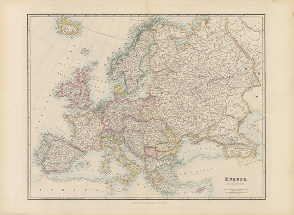
Stanford's Folio Europe Map by J. Arrowsmith published 1884
$59.95
or make 4 interest-free payments of
$14.99 AUD
fortnightly with
![]() More info
More info
A Masterpiece from the Golden Age of Cartography Published: 1884
Cartographer: John Arrowsmith
From the Edward Stanford Cartographic Collection Archive
A Rare Glimpse into Imperial Europe
This stunning historical reproduction of Stanford’s Folio Map of Europe, crafted by the eminent British cartographer John Arrowsmith and published by Edward Stanford in 1884, is more than just a map—it is a window into a continent poised on the edge of transformation.
The late 19th century was a time of consolidated empires, vibrant capitals, and imperial intrigue, and this meticulously rendered map captures that moment in breathtaking detail. It is an essential piece for anyone fascinated by the politics, geography, and international relations of pre-World War I Europe.
What This Map Shows
This is Europe at the height of its imperial drama—before the wars, treaties, and revolutions of the 20th century redrew its boundaries:
-
Imperial Russia extends west into Finland and much of present-day Poland
-
The German Empire, unified just over a decade prior, includes Alsace and part of Lorraine, symbolising its growing might in central Europe
-
The Austro-Hungarian Empire spans from Vienna through Hungary and into the Balkans—still holding sway over diverse ethnic groups within its dominion
-
The Ottoman Empire, though in decline, still controls Albania and regions of Greece, its footprint marked clearly
-
Scandinavia, France, Spain, and Italy appear as they stood on the cusp of modernity
Country boundaries are hand-coloured in bold, vibrant tints that elegantly contrast with the pale hatching used to denote mountainous terrain. This makes both political and physical geography easy to distinguish. River networks, mountain ranges, and coastlines are rendered with remarkable precision, while smaller rivers, regional towns, and provincial names are included in abundance—testament to Arrowsmith’s meticulous attention to detail.
Latitude and longitude lines are drawn at 5-degree intervals, and the map’s scale allows for meaningful exploration without clutter.
About the Cartographer
John Arrowsmith (1790–1873) was one of Britain’s most influential 19th-century mapmakers, part of the famed Arrowsmith family of cartographers. His work was revered across Europe and the British Empire for its scientific precision and artistic presentation. This map reflects the culmination of his expertise and the cartographic excellence of the Stanford publishing house.
Finishing Options
| Finish | Description |
|---|---|
| 160gsm Paper | Ideal for framing under glass – rich in detail, archival quality |
| Laminated | Encapsulated in 80-micron gloss laminate – waterproof, wipe-clean, highly durable |
| Canvas (395gsm) | Printed on museum-grade HP Professional Matte Canvas using pigment-based inks – fade-resistant and made to last |
Optional Hang Rails
Laminated & Canvas versions can be supplied with natural timber hang rails attached top and bottom, complete with a hanging cord for easy wall display. This classic method of presentation not only enhances the vintage look but makes installation quick and tool-free.
🛠️ Please allow up to 10 working days for hang-railed maps, as each one is custom-finished by our professional framer.
Why This Map Matters
-
A striking educational tool for students of history, geography, and politics
-
A decorative centrepiece for libraries, studies, classrooms, and offices
-
A collectible reproduction of a pre-WWI European landscape, marking the final decades of the great continental empires
-
An excellent conversation piece for anyone fascinated by Europe’s evolving boundaries
Whether you’re a history buff, interior designer, educator, or map collector, this is more than a decorative item—it’s a historically significant document, expertly restored and printed to the highest standard.
Product Summary
| Feature | Details |
|---|---|
| Title | Stanford’s Folio Map of Europe (1884) by J. Arrowsmith |
| Original Publisher | Edward Stanford Ltd., London |
| Original Cartographer | John Arrowsmith |
| Map Style | Political and physical – imperial borders, rivers, and regions |
| Projection | Likely Cylindrical, with lat/lon at 5° intervals |
| Print Material (Paper) | 160gsm archival-quality matte stock |
| Laminated Option | Encapsulated in dual-layer 80-micron gloss laminate |
| Canvas Option | 395gsm HP Professional Matte Canvas with pigment-based inks |
| Hanging Option | Natural timber rails with hanging cord |
| Sizes Available | 745 mm (w) x 546 mm (h) |
| Production Location | Printed and finished in Australia |
| Shipping Note | Please allow up to 10 working days for hang-railed canvas maps |
Add Depth to Your Wall – And History to Your Home
This is more than just a map. It is a snapshot of Europe in an era of powerful monarchs, restless borders, and unfolding global empires. Bring a touch of 19th-century grandeur to your space with this authoritative and beautifully presented reproduction.
Secure yours today – and own a piece of Europe’s cartographic past.


