- Australia ▾
- Topographic
▾
- Australia AUSTopo 250k (2025)
- Australia 50k Geoscience maps
- Australia 100k Geoscience maps
- Australia 250k Geoscience maps
- Australia 1:1m Geoscience maps
- New Zealand 50k maps
- New Zealand 250k maps
- New South Wales 25k maps
- New South Wales 50k maps
- New South Wales 100k maps
- Queensland 10k maps
- Queensland 25k maps
- Queensland 50k maps
- Queensland 100k maps
- Western Australia 25k maps
- Western Australia 50k maps
- Western Australia 100k maps
- Compasses
- Software
- GPS Systems
- International ▾
- Wall Maps
▾
- World
- Australia & New Zealand
- Countries, Continents & Regions
- Historical
- Vintage National Geographic
- Australian Capital Territory
- New South Wales
- Northern Territory
- Queensland
- South Australia
- Tasmania
- Victoria
- Western Australia
- Celestial
- Children's
- Mining & Resources
- Wine Maps
- Healthcare
- Postcode Maps
- Electoral Maps
- Nautical ▾
- Flags
▾
- Australian Flag Sets & Banners
- Flag Bunting
- Handwavers
- Australian National Flags
- Aboriginal Flags
- Torres Strait Islander Flags
- International Flags
- Flagpoles & Accessories
- Australian Capital Territory Flags
- New South Wales Flags
- Northern Territory Flags
- Queensland Flags
- South Australia Flags
- Tasmania Flags
- Victoria Flags
- Western Australia Flags
- Gifts ▾
- Globes ▾
Dear valued customer. Please note that our checkout is not supported by old browsers. Please use a recent browser to access all checkout capabilities


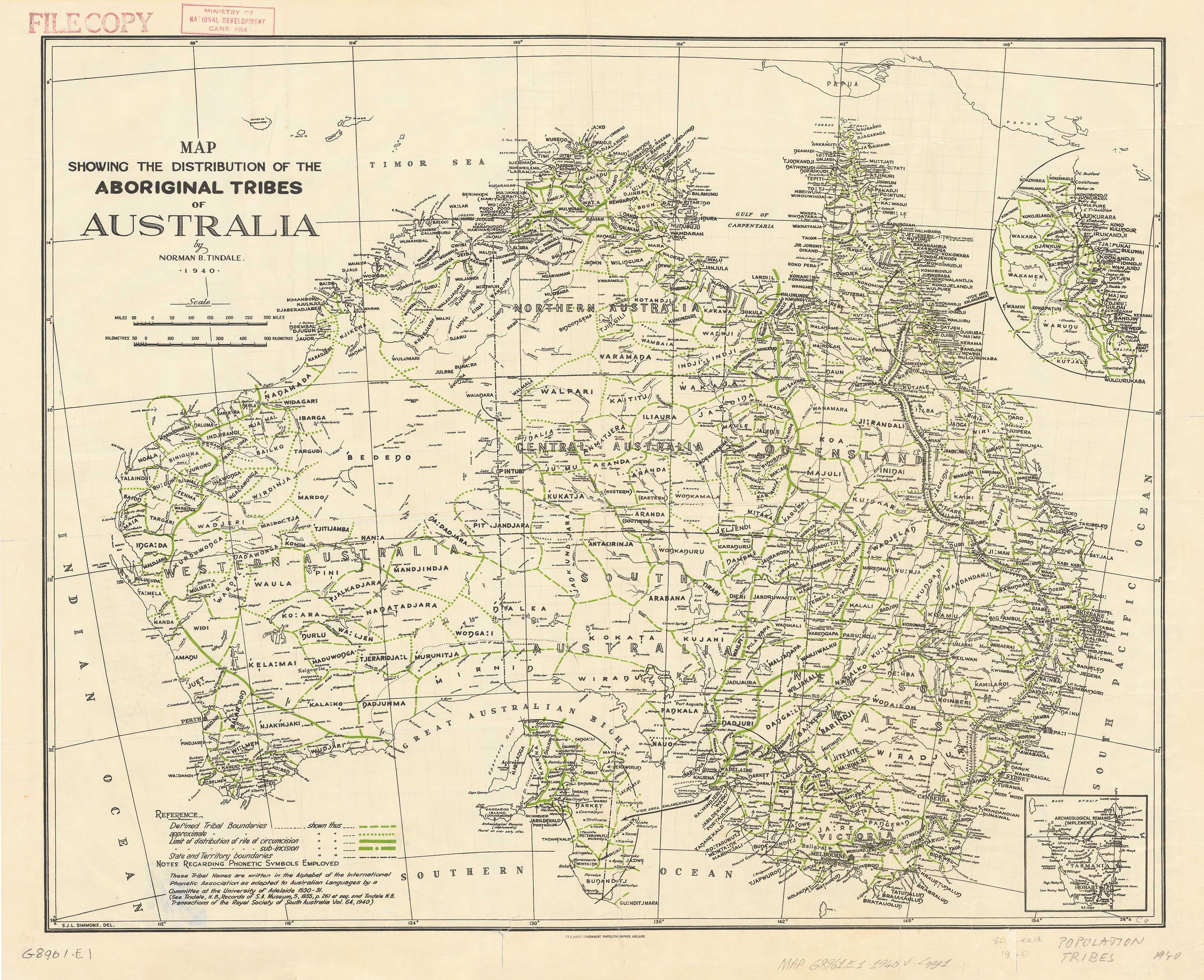

Norman Tindale’s 1940 Map of Aboriginal Tribal Boundaries
$59.95
or make 4 interest-free payments of
$14.99 AUD
fortnightly with
![]() More info
More info
A landmark in the cartographic and anthropological history of Australia
This meticulously reproduced edition of Norman Barnett Tindale’s 1940 map remains one of the most influential and enduring visual documents in Australian history. It represents a formative moment in the Western understanding of Aboriginal Australia, mapping the distribution of Indigenous tribal groups across the continent as understood by Tindale at the time. What makes this version particularly significant are the original pencil annotations by Tindale himself, offering an extraordinary glimpse into the personal process and evolving understanding behind his pioneering work.
🌏 A Groundbreaking Vision of Country
Prior to Tindale’s research, the prevailing view among academics and colonial institutions was that Aboriginal Australians were essentially nomadic, without enduring territorial boundaries. Tindale, drawing on extensive fieldwork conducted over decades, systematically gathered genealogical, linguistic, and geographic data directly from Aboriginal communities.
In doing so, he proposed a map that charted clearly defined tribal territories across Australia—an idea that, while later updated through Indigenous-led and collaborative research, revolutionised anthropological and governmental perspectives at the time. His work contributed significantly to the recognition of Aboriginal people's deep, spiritual connection to the land—laying an early foundation for future dialogues around land rights, cultural identity, sovereignty, and reconciliation.
Tindale later expanded upon his findings in his seminal 1974 publication, Aboriginal Tribes of Australia, but this 1940 map remains a foundational visual expression of his life’s work. It is as much a cartographic record as it is a cultural artefact—bridging scientific inquiry and Indigenous heritage.
📜 About the Reproduction
This edition is faithfully reproduced from the original, retaining all geographical and artistic detail—including Tindale’s own handwritten pencil notations along the lower edge. These marginal notes add not only visual authenticity but also a rare insight into the cartographer's evolving interpretations and observations at the time of publication.
Available Finishes
We offer this historically significant map in a range of premium presentation formats, ensuring suitability for both preservation and display:
Heavyweight Archival Paper (170 gsm FSC Matte-Coated)
-
Ideal for framing under glass
-
Smooth matte finish ensures clarity and a classic look
-
Maintains the integrity of fine lines and detailed tribal boundaries
-
Perfect for libraries, academic collections, and professional framing
Laminated (Encapsulated)
-
Encapsulated between two sheets of 80-micron gloss laminate
-
Extremely durable—resistant to tears, moisture, UV fade, and handling
-
Suitable for educational institutions, public spaces, classrooms, and museums
-
Can be used with non-permanent markers for teaching or referencing
Archival Canvas (395 gsm HP Professional Matte)
-
Printed using pigment-based, fade-resistant inks for colour longevity
-
Durable, textured surface adds depth and warmth
-
Perfect for galleries, boardrooms, cultural centres, or private collectors
-
Offers a museum-quality finish that honours the map’s historical value
Timber Hanging Rails (Optional for Canvas Versions)
For a distinguished and ready-to-hang finish, canvas maps can be mounted with natural timber hang rails:
-
Timber comes lacquered in a neutral finish to complement all decor
-
Attached with a hanging cord for effortless wall installation
-
Gives the map a clean, gallery-style aesthetic
-
Please allow up to 10 working days for custom framing and assembly
📏 Sizes Available
-
Standard: 790 mm (W) × 640 mm (H)
-
Large: 1150 mm (W) × 920 mm (H)
-
Oversize: 1500 mm (W) × 1220 mm (H)
Custom sizes may be available on request for special collections or public installations.
📚 Publication Information
-
Original Map Published: 1940
-
Cartographer: Norman Barnett Tindale
-
Reproduction Rights: Licensed historical edition
-
Produced in: Australia
🎯 Ideal For
-
Universities and schools teaching Australian history, anthropology, and Indigenous studies
-
Cultural institutions and museums seeking a centrepiece for exhibitions
-
Government departments, land councils, and legal entities involved in native title or heritage recognition
-
Private collectors, archivists, and anyone with an appreciation for historically significant cartography
-
Indigenous organisations and community spaces honouring Country and cultural connection
Norman Tindale’s 1940 Map is more than a historical document—it’s a visual testament to the complexity, richness, and continuity of Aboriginal Australia. Whether hung in a lecture hall, cultural centre, or private study, this reproduction offers a powerful, thought-provoking insight into Australia’s deep past and continuing journey toward understanding.
Explore the land through Tindale’s lens—and honour the stories it still holds.
Frequently Asked Questions
What are the dimensions of the Norman Tindale’s 1940 Map of Aboriginal Tribal Boundaries?
Mapworld wall maps range from standard 700×1000mm to large-format 1000×1430mm Supermaps. The exact dimensions for this map are shown in the product title. Where multiple sizes are available, select your preferred size when adding to cart.
Is this wall map available laminated?
Many Mapworld wall maps are available in paper, laminated, or framed finishes. Check the product options when adding to cart. Laminated maps are wipe-clean and more durable.
Is this the latest edition?
Mapworld stocks the most current editions available from all publishers. Edition year is shown in the product title where applicable. Mapworld updates its catalogue as new editions are released.
Can I write on or pin this wall map?
Laminated wall maps can be written on with whiteboard markers and wiped clean. Paper maps can be pinned on a corkboard. Choose a laminated option for a writeable surface.
Does Mapworld ship the Norman Tindale’s 1940 Map of Aboriginal Tribal Boundaries across Australia?
Yes, Mapworld ships Australia-wide. Standard shipping is a flat $7 rate, with free standard shipping on orders over $75. Express options are available at checkout. Most orders placed before 2pm AEST on weekdays are dispatched same day.
Related Items


© 2026 Mapworld. Website designed by Genie Media
X