- Australia ▾
- Topographic
▾
- Australia AUSTopo 250k (2025)
- Australia 50k Geoscience maps
- Australia 100k Geoscience maps
- Australia 250k Geoscience maps
- Australia 1:1m Geoscience maps
- New Zealand 50k maps
- New Zealand 250k maps
- New South Wales 25k maps
- New South Wales 50k maps
- New South Wales 100k maps
- Queensland 10k maps
- Queensland 25k maps
- Queensland 50k maps
- Queensland 100k maps
- Western Australia 25k maps
- Western Australia 50k maps
- Western Australia 100k maps
- Compasses
- Software
- GPS Systems
- International ▾
- Wall Maps
▾
- World
- Australia & New Zealand
- Countries, Continents & Regions
- Historical
- Vintage National Geographic
- Australian Capital Territory
- New South Wales
- Northern Territory
- Queensland
- South Australia
- Tasmania
- Victoria
- Western Australia
- Celestial
- Children's
- Mining & Resources
- Wine Maps
- Healthcare
- Postcode Maps
- Electoral Maps
- Nautical ▾
- Flags
▾
- Australian Flag Sets & Banners
- Flag Bunting
- Handwavers
- Australian National Flags
- Aboriginal Flags
- Torres Strait Islander Flags
- International Flags
- Flagpoles & Accessories
- Australian Capital Territory Flags
- New South Wales Flags
- Northern Territory Flags
- Queensland Flags
- South Australia Flags
- Tasmania Flags
- Victoria Flags
- Western Australia Flags
- Gifts ▾
- Globes ▾
Dear valued customer. Please note that our checkout is not supported by old browsers. Please use a recent browser to access all checkout capabilities


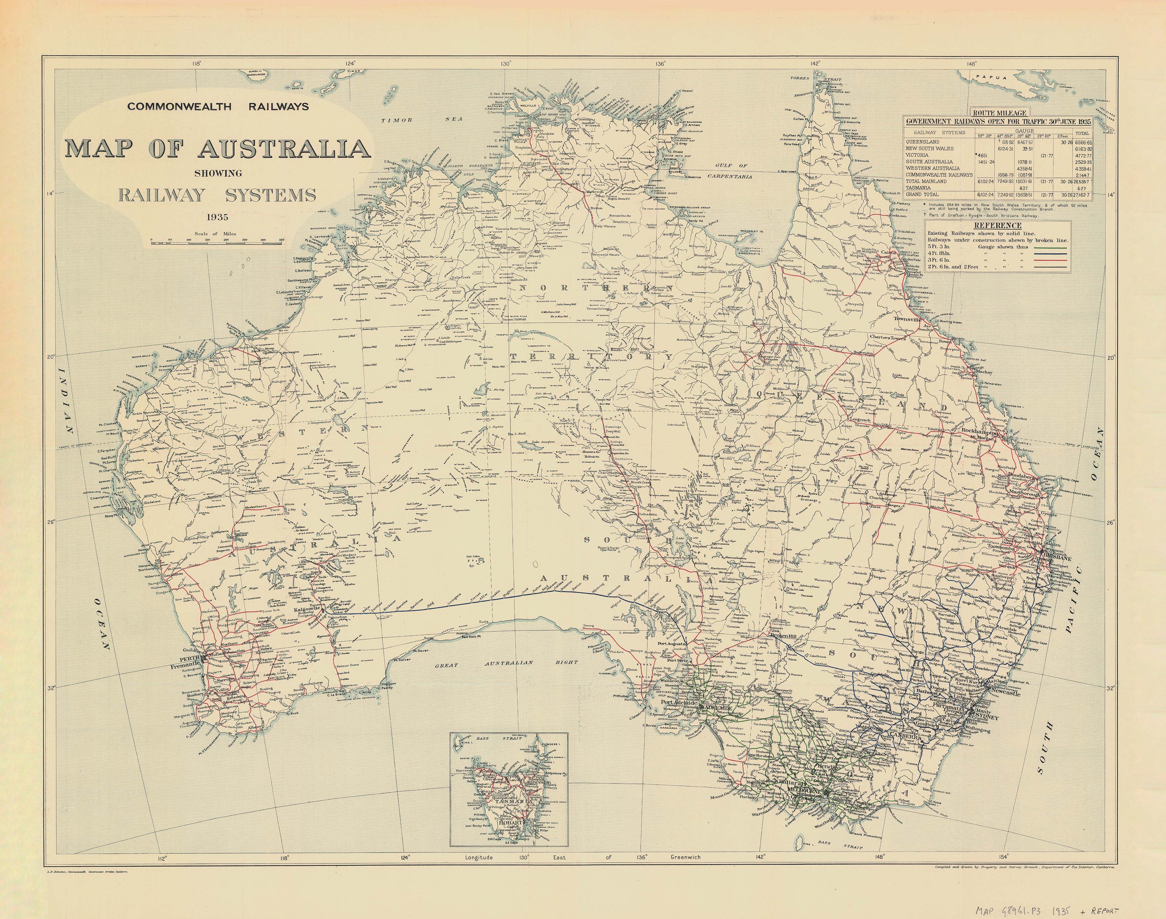
Vintage Railway Wall Map of Australia published 1935
$69.95
or make 4 interest-free payments of
$17.49 AUD
fortnightly with
![]() More info
More info
Published: 1935 | Available in 3 Sizes | Paper, Laminated or Canvas Finish
Step back in time with this faithful reproduction of the Commonwealth Railways Map of Australia, originally published on 30 June 1935. A striking historical piece and a fascinating insight into the country’s early railway development, this map vividly displays the government railway networks open to traffic in 1935, with colour-coded lines that reflect the four different railway gauges used across Australia at the time.
A Stunning Piece of Railway History
Authentic 1935 Design
-
Reproduction of the official Commonwealth Railways publication
-
Shows the operational railway lines as of mid-1935
-
Gauge sizes are clearly colour-coded for ease of reference
-
A compelling visual record of Australian infrastructure history
Perfect for Railway Enthusiasts, History Buffs & Collectors
-
Ideal for framing in a study, office, library or man cave
-
Makes a unique and thoughtful gift for transport lovers and heritage aficionados
🖼️ Available Finishes
160gsm Paper Print
-
Ideal for framing under glass
-
Crisp, archival-quality reproduction
-
Matte finish to reduce glare
Laminated (Encapsulated)
-
True encapsulation in 80-micron gloss laminate (front and back)
-
Tear- and stain-resistant
-
Write-on/wipe-off surface—great for educational use
395gsm Matte Canvas (Premium Option)
-
Printed using pigment-based inks on HP Professional Matte Canvas
-
Durable, fade-resistant, and exquisitely detailed
-
Option to add timber hang rails for a ready-to-display vintage look
Optional Timber Hang Rails
-
Lacquered in a natural finish
-
Easy to hang with a cord attached to the top rail
-
Please allow 10 working days for hang rail preparation by our framer
📏 Available Sizes
| Size Label | Dimensions (W x H) |
|---|---|
| Standard | 800 mm x 640 mm |
| Large | 1150 mm x 920 mm |
| Oversize | 1800 mm x 1450 mm |
Select your preferred size and finish from the dropdown menu above.
📦 Product Specifications
| Feature | Details |
|---|---|
| Map Title | Commonwealth Railways Map of Australia |
| Original Date | 30 June 1935 |
| Map Features | Rail networks by gauge, state boundaries |
| Materials | Paper / Laminated / Canvas |
| Print Quality | Archival-grade, fade-resistant inks |
| Canvas Option | HP 395gsm Matte Canvas + Hang Rails (opt.) |
Perfect For:
✔️ Railway historians and collectors
✔️ Home and office décor with a vintage twist
✔️ Education and transport enthusiasts
✔️ Museum displays or heritage centres
This 1935 Vintage Railway Map of Australia offers not just a glimpse into the nation’s transport past but a timeless decorative piece. With multiple sizes and finishes available, including our stunning canvas + hang rail format, this map is both an informative reference and a piece of art that celebrates Australia’s rail heritage in style.
🛒 Add to Cart Today – and bring home a classic piece of Australian cartographic history.
Frequently Asked Questions
What are the dimensions of the Vintage Railway Wall Map of Australia published 1935?
Mapworld wall maps range from standard 700×1000mm to large-format 1000×1430mm Supermaps. The exact dimensions for this map are shown in the product title. Where multiple sizes are available, select your preferred size when adding to cart.
Is this wall map available laminated?
Many Mapworld wall maps are available in paper, laminated, or framed finishes. Check the product options when adding to cart. Laminated maps are wipe-clean and more durable.
Is this the latest edition?
Mapworld stocks the most current editions available from all publishers. Edition year is shown in the product title where applicable. Mapworld updates its catalogue as new editions are released.
Can I write on or pin this wall map?
Laminated wall maps can be written on with whiteboard markers and wiped clean. Paper maps can be pinned on a corkboard. Choose a laminated option for a writeable surface.
Does Mapworld ship the Vintage Railway Wall Map of Australia published 1935 across Australia?
Yes, Mapworld ships Australia-wide. Standard shipping is a flat $7 rate, with free standard shipping on orders over $75. Express options are available at checkout. Most orders placed before 2pm AEST on weekdays are dispatched same day.
Related Items


© 2026 Mapworld. Website designed by Genie Media
X