- Australia ▾
- Topographic
▾
- Australia AUSTopo 250k (2025)
- Australia 50k Geoscience maps
- Australia 100k Geoscience maps
- Australia 250k Geoscience maps
- Australia 1:1m Geoscience maps
- New Zealand 50k maps
- New Zealand 250k maps
- New South Wales 25k maps
- New South Wales 50k maps
- New South Wales 100k maps
- Queensland 10k maps
- Queensland 25k maps
- Queensland 50k maps
- Queensland 100k maps
- Western Australia 25k maps
- Western Australia 50k maps
- Western Australia 100k maps
- Compasses
- Software
- GPS Systems
- International ▾
- Wall Maps
▾
- World
- Australia & New Zealand
- Countries, Continents & Regions
- Historical
- Vintage National Geographic
- Australian Capital Territory
- New South Wales
- Northern Territory
- Queensland
- South Australia
- Tasmania
- Victoria
- Western Australia
- Celestial
- Children's
- Mining & Resources
- Wine Maps
- Healthcare
- Postcode Maps
- Electoral Maps
- Nautical ▾
- Flags
▾
- Australian Flag Sets & Banners
- Flag Bunting
- Handwavers
- Australian National Flags
- Aboriginal Flags
- Torres Strait Islander Flags
- International Flags
- Flagpoles & Accessories
- Australian Capital Territory Flags
- New South Wales Flags
- Northern Territory Flags
- Queensland Flags
- South Australia Flags
- Tasmania Flags
- Victoria Flags
- Western Australia Flags
- Gifts ▾
- Globes ▾
Dear valued customer. Please note that our checkout is not supported by old browsers. Please use a recent browser to access all checkout capabilities


Vintage Aviation Wall Map of Australia 1948
$79.95
or make 4 interest-free payments of
$19.99 AUD
fortnightly with
![]() More info
More info
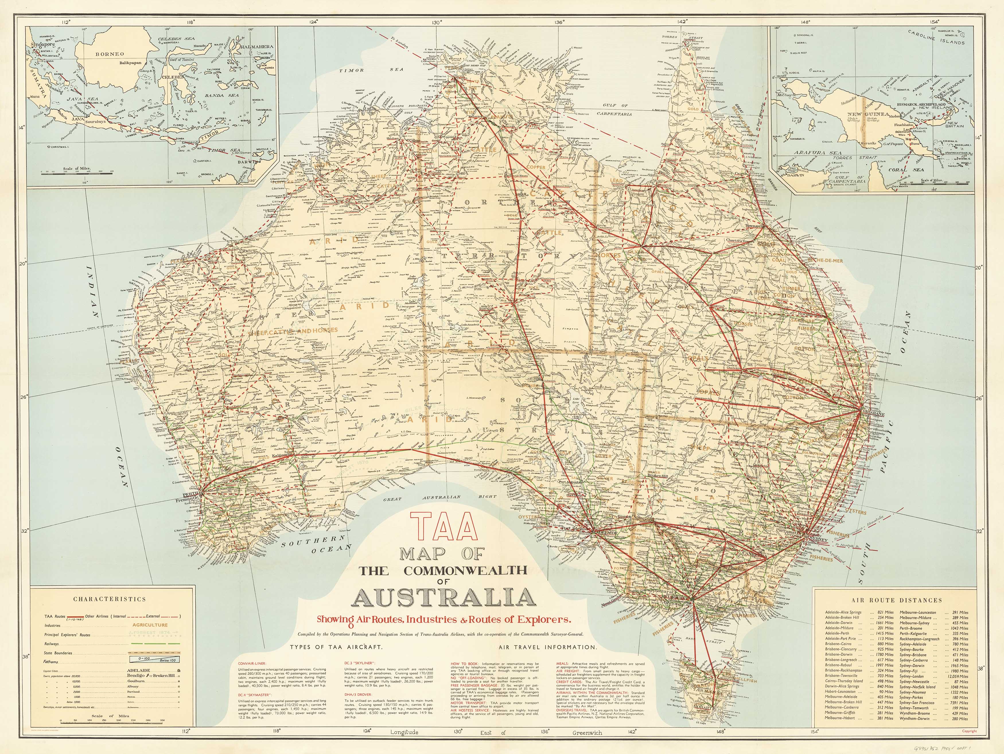
Trans Australia Airlines Map of the Commonwealth – Featuring Air Routes, Explorers’ Tracks & Industry of a Nation in Flight
Published: 1948
Available in Two Sizes:
-
Standard: 1000 mm (w) x 750 mm (h)
-
Supermap: 1900 mm (w) x 1450 mm (h)
Step back into the golden age of Australian aviation with this beautifully reproduced 1948 Trans Australia Airlines Map of the Commonwealth of Australia. Originally printed just two years after TAA's founding in 1946, this map is both a historical document and a decorative masterpiece, celebrating the dawn of commercial air travel across the vast Australian continent.
More than just a map, it captures a post-war nation on the move—with flight paths spanning out across the country, industries springing up from coast to outback, and a new era of exploration marked by propeller-driven aircraft and pioneering spirit.
✈️ A Nation in Flight: What the Map Shows
This vintage map presents a vivid snapshot of Australia's transportation and economic geography as it stood in 1948, including:
-
✈️ Air routes of Trans Australia Airlines and other early carriers, with flight distances shown in a dedicated table
-
🛩️ Aircraft illustrations and descriptions of planes then in service—such as the DC-3 “Skyliner,” DC-4 “Skymaster,” Convair-Liner, and the DHA-3 “Drover”
-
🧭 Routes of early Australian explorers, tracing their perilous inland journeys
-
🏭 Industrial zones, including mining, agriculture, and pastoral activities across the states
-
🚂 Major railway lines, threading the interior before jet age travel changed the landscape forever
The map is a blend of cartography and storytelling, offering a nostalgic look at an era when air travel was both glamorous and pioneering.
About Trans Australia Airlines (TAA)
Established in 1946 as a government-owned carrier, TAA was a foundational force in Australia's domestic aviation industry. Operating until 1992 when it merged with Qantas, TAA brought air travel to remote towns and regional centres, reducing a week’s travel to a day’s flight and helping knit together a vast, isolated nation.
This 1948 map commemorates TAA’s early ambition: to connect Australians through the sky while supporting the industrial and economic development of the post-war nation.
🖨️ Finishing Options: Choose Your Style
| Option | Description |
|---|---|
| 🧾 160 gsm Paper | Crisp, heavyweight paper ideal for framing under glass. Clean, sharp lines with a vintage feel. |
| 🛡️ Laminated (80-micron gloss) | Encapsulated for maximum durability – water-resistant and wipe-clean. Great for high-traffic areas. |
| 🖼️ 395 gsm HP Matte Canvas | Printed using pigment-based archival inks on museum-grade canvas. Rich texture, fade-resistant, and suitable for gallery-style hanging. |
Optional Hang Rails (Laminated & Canvas)
Laminated & Canvas versions can be fitted with natural timber hang rails, top and bottom, for effortless, elegant display:
-
Ready-to-hang with a cord on the top rail
-
Rails are lacquered in a warm wood tone
-
No framing required – just add a hook to the wall
📦 Please allow up to 10 working days for delivery of hang-railed versions as they are individually prepared by our framer.
🧭 Product Summary
| Feature | Detail |
|---|---|
| Map Title | Trans Australia Airlines Map of Australia (1948) |
| Original Publisher | TAA / Commonwealth Government |
| Reproduction Type | Archival-quality reprint |
| Sizes Available | 1000 mm x 750 mm or 1900 mm x 1450 mm |
| Format | Paper, Laminated, or Canvas |
| Finish Options | Flat, Laminated, or Canvas |
| Printed In | Australia |
🧳 Perfect For:
-
✈️ Aviation historians and enthusiasts
-
🖼️ Collectors of vintage transport and travel art
-
🏢 Office and home decor with a nostalgic or industrial edge
-
📚 Educational displays in libraries, schools, or museums
-
🎁 A memorable gift for pilots, travellers, or lovers of cartographic history
The 1948 TAA Map of Australia is a tribute to a transformative time in Australia’s history—when explorers still traced the inland with grit and compass, but the sky was becoming the new frontier. It's a beautiful way to honour that story—and to bring the vintage elegance of early air travel into your space.
Fly back in time. Map a nation in flight.
Frequently Asked Questions
What are the dimensions of the Vintage Aviation Wall Map of Australia 1948?
Mapworld wall maps range from standard 700×1000mm to large-format 1000×1430mm Supermaps. The exact dimensions for this map are shown in the product title. Where multiple sizes are available, select your preferred size when adding to cart.
Is this wall map available laminated?
Many Mapworld wall maps are available in paper, laminated, or framed finishes. Check the product options when adding to cart. Laminated maps are wipe-clean and more durable.
Is this the latest edition?
Mapworld stocks the most current editions available from all publishers. Edition year is shown in the product title where applicable. Mapworld updates its catalogue as new editions are released.
Can I write on or pin this wall map?
Laminated wall maps can be written on with whiteboard markers and wiped clean. Paper maps can be pinned on a corkboard. Choose a laminated option for a writeable surface.
Does Mapworld ship the Vintage Aviation Wall Map of Australia 1948 across Australia?
Yes, Mapworld ships Australia-wide. Standard shipping is a flat $7 rate, with free standard shipping on orders over $75. Express options are available at checkout. Most orders placed before 2pm AEST on weekdays are dispatched same day.
Related Items


© 2026 Mapworld. Website designed by Genie Media
X