- Australia ▾
- Topographic
▾
- Australia AUSTopo 250k (2025)
- Australia 50k Geoscience maps
- Australia 100k Geoscience maps
- Australia 250k Geoscience maps
- Australia 1:1m Geoscience maps
- New Zealand 50k maps
- New Zealand 250k maps
- New South Wales 25k maps
- New South Wales 50k maps
- New South Wales 100k maps
- Queensland 10k maps
- Queensland 25k maps
- Queensland 50k maps
- Queensland 100k maps
- Compasses
- Software
- GPS Systems
- Orienteering
- International ▾
- Wall Maps
▾
- World
- Australia & New Zealand
- Countries, Continents & Regions
- Historical
- Vintage National Geographic
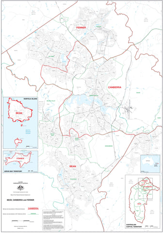
- Australian Capital Territory
- New South Wales
- Northern Territory
- Queensland
- South Australia
- Tasmania
- Victoria
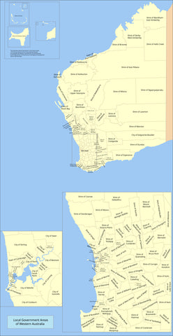
- Western Australia
- Celestial
- Children's
- Mining & Resources
- Wine Maps
- Healthcare
- Postcode Maps
- Electoral Maps
- Nautical ▾
- Flags
▾
- Australian Flag Sets & Banners
- Flag Bunting
- Handwavers
- Australian National Flags
- Aboriginal Flags
- Torres Strait Islander Flags
- International Flags
- Flagpoles & Accessories
- Australian Capital Territory Flags
- New South Wales Flags
- Northern Territory Flags
- Queensland Flags
- South Australia Flags
- Tasmania Flags
- Victoria Flags
- Western Australia Flags
- Gifts ▾
- Globes ▾
Dear valued customer. Please note that our checkout is not supported by old browsers. Please use a recent browser to access all checkout capabilities


Electoral and LGA Maps
Australian electoral wall maps provide a detailed and accurate overview of federal, state, and local electoral boundaries—essential for understanding the political landscape across the country. These maps clearly outline divisions, electorates, and districts, making them invaluable tools for campaign planning, policy work, civic education, and community engagement.
Whether you’re working in government, politics, education, or advocacy, our collection includes high-quality electoral maps covering all Australian states and territories. Available in a range of sizes and finishes, they’re ideal for offices, classrooms, council chambers, or any space where clear political geography matters. With an electoral wall map, complex boundaries become easy to navigate and understand.


About LGA & Electoral Wall Maps
An LGA (Local Government Area) wall map shows every council, shire and city boundary across a state or region — making it possible to see which suburbs sit in which council, where service catchments overlap, and how administrative geography is structured. Electoral division maps do the same for federal and state political boundaries — essential for political analysis, campaign planning, government affairs and journalism.
Australia's LGA and electoral boundaries are surprisingly complex. There are over 530 LGAs across Australia (from massive shires covering hundreds of thousands of square kilometres to tightly packed metropolitan councils), 151 federal electorates, and several hundred state electorates. They don't always align, and they change as redistribution happens. A current, well-designed wall map turns this complexity into something you can plan from.
Choosing the Right LGA or Electoral Map
| Use case | Recommended map |
|---|---|
| Local council operations / service planning | State LGA wall map for your state |
| Real estate / multi-council territory work | State LGA wall map (often paired with our postcode wall maps) |
| Political campaigning / electoral analysis | Federal electoral divisions wall map for your state, plus state electoral map if relevant |
| Journalism / political analysis / government affairs | Combined Electoral and LGA wall map (where available — SA has a great example) |
| Healthcare service catchments | State LGA wall map (often the foundation layer for catchment overlays) |
| Marketing / customer territory by council | State LGA wall map plus optional postcode overlay |
| Education / classroom reference | State LGA or Electoral wall map, framed for permanent display |
Coverage
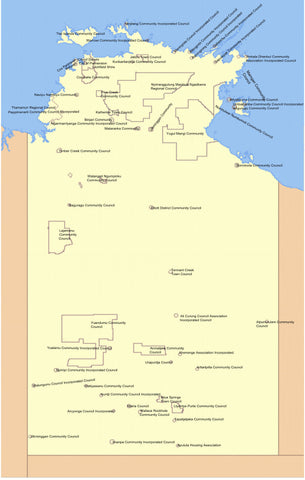
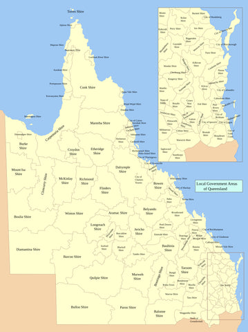
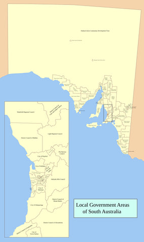
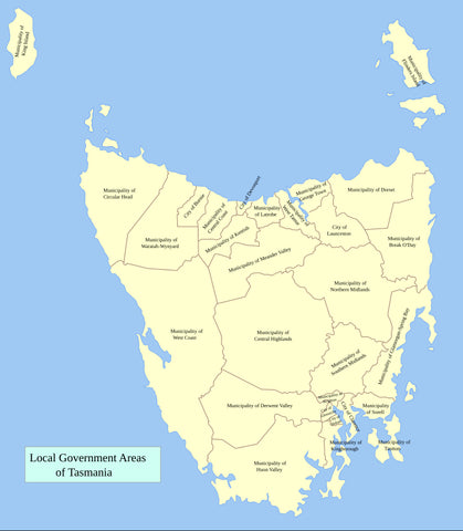
State LGA Wall Maps
Mapworld stocks dedicated Local Government Areas wall maps for New South Wales, Victoria, Queensland, South Australia, Western Australia and Tasmania. Each shows every council, shire and city boundary in that state, labelled and colour-coded for clarity. Most are 788 × 1110mm or larger, laminated.
Federal Electoral Divisions
Federal electoral wall maps cover the 151 House of Representatives divisions across Australia. Available state-by-state and as combined Electoral & LGA maps for states where boundaries intersect in interesting ways (South Australia is the standout — our SA Federal Electoral Divisions and LGA — Adelaide Metro map combines both layers in a single reference).
State Electoral Maps
State Legislative Assembly and Legislative Council electoral wall maps are available for the major states. These show state-level political boundaries which often differ from federal electorates and are essential for state-level political analysis or government affairs.
Metropolitan and Regional Variants
For some states, dedicated metropolitan-area maps offer higher detail than state-wide versions — for example, the Adelaide Metro Federal Electoral and LGA combined map, and the New South Wales Electoral and LGA — Metropolitan Sydney and Newcastle area maps.
Custom & Branded LGA / Electoral Maps
Mapworld's most-used service for council, government and political clients is custom mapping. We can produce wall maps with your specific service catchments overlaid on LGA boundaries, branch territories aligned to electoral divisions, ward-level boundaries within a single council, customer or member density by LGA, healthcare or education service zones, and emergency response areas. Maps can be branded with your council, agency or party logo, sized to fit a specific wall, and supplied laminated, framed or rolled. Call 1300 795 697 to discuss a custom job.
Why Buy LGA Maps from Mapworld
- Largest Australian LGA wall map range — every state plus combined Electoral / LGA versions where they exist
- Current boundaries — we rotate stock as state redistributions and AEC adjustments come through
- Laminated finish — whiteboard-marker compatible for ongoing planning, catchment markup, territory definition
- Custom mapping service — service catchments, ward boundaries, customer overlays, branded maps for councils and government
- Same-day dispatch on weekday orders before 2 pm AWST. Free shipping over $75, flat $7 below
- 25+ years specialising in Australian maps — we know what councils, MPs' offices, real estate agencies and government planners actually need
Frequently Asked Questions
What is the difference between an LGA map and an electoral map?
An LGA (Local Government Area) map shows council, shire and city boundaries — the local government layer. An electoral map shows federal or state political division boundaries used for elections. They're different boundary systems and don't always align. For real estate, council services and most business uses, you want LGA. For political analysis and campaigning, you want electoral.
Are these the current LGA boundaries?
Yes. State governments adjust LGA boundaries periodically (council amalgamations, ward changes, etc.) and the AEC redistributes federal electorates regularly. Mapworld stocks current editions and rotates stock as updates are published. Each product page lists the edition year.
Do you offer custom LGA maps for councils?
Yes. Mapworld runs a dedicated custom mapping service for councils, government departments, political offices and consultancies. Common jobs include service catchment overlays, ward boundary maps within a single LGA, branch or franchise territories aligned to council boundaries, customer or member density mapping, and branded maps for council offices.
Can I write on these LGA wall maps?
Yes. All laminated LGA and electoral wall maps can be marked with whiteboard markers and wiped clean — designed for ongoing territory planning, catchment markup and service area definition.
Do you stock combined Electoral and LGA maps?
Yes for some states. The South Australia Federal Electoral Divisions and Local Government Areas Map (Adelaide Metro) is the standout — both boundary systems on a single reference. NSW has metropolitan combined versions covering Sydney and Newcastle. Other states are typically single-layer.
How fast is shipping?
Orders placed before 2 pm AWST on weekdays dispatch same-day from our Perth warehouse. Wall maps ship rolled in a tube via tracked courier. Most metro deliveries arrive in 2 to 5 business days. Free shipping on orders over $75; flat $7 below that.
For state-specific postcode coverage, the South Australia postcode wall map is the standard SA reference for real estate and sales territory work.
© 2026 Mapworld. Website designed by Genie Media
X