- Australia ▾
- Topographic
▾
- Australia AUSTopo 250k (2025)
- Australia 50k Geoscience maps
- Australia 100k Geoscience maps
- Australia 250k Geoscience maps
- Australia 1:1m Geoscience maps
- New Zealand 50k maps
- New Zealand 250k maps
- New South Wales 25k maps
- New South Wales 50k maps
- New South Wales 100k maps
- Queensland 10k maps
- Queensland 25k maps
- Queensland 50k maps
- Queensland 100k maps
- Western Australia 25k maps
- Western Australia 50k maps
- Western Australia 100k maps
- Compasses
- Software
- GPS Systems
- International ▾
- Wall Maps
▾
- World
- Australia & New Zealand
- Countries, Continents & Regions
- Historical
- Vintage National Geographic
- Australian Capital Territory
- New South Wales
- Northern Territory
- Queensland
- South Australia
- Tasmania
- Victoria
- Western Australia
- Celestial
- Children's
- Mining & Resources
- Wine Maps
- Healthcare
- Postcode Maps
- Electoral Maps
- Nautical ▾
- Flags
▾
- Australian Flag Sets & Banners
- Flag Bunting
- Handwavers
- Australian National Flags
- Aboriginal Flags
- Torres Strait Islander Flags
- International Flags
- Flagpoles & Accessories
- Australian Capital Territory Flags
- New South Wales Flags
- Northern Territory Flags
- Queensland Flags
- South Australia Flags
- Tasmania Flags
- Victoria Flags
- Western Australia Flags
- Gifts ▾
- Globes ▾
Dear valued customer. Please note that our checkout is not supported by old browsers. Please use a recent browser to access all checkout capabilities


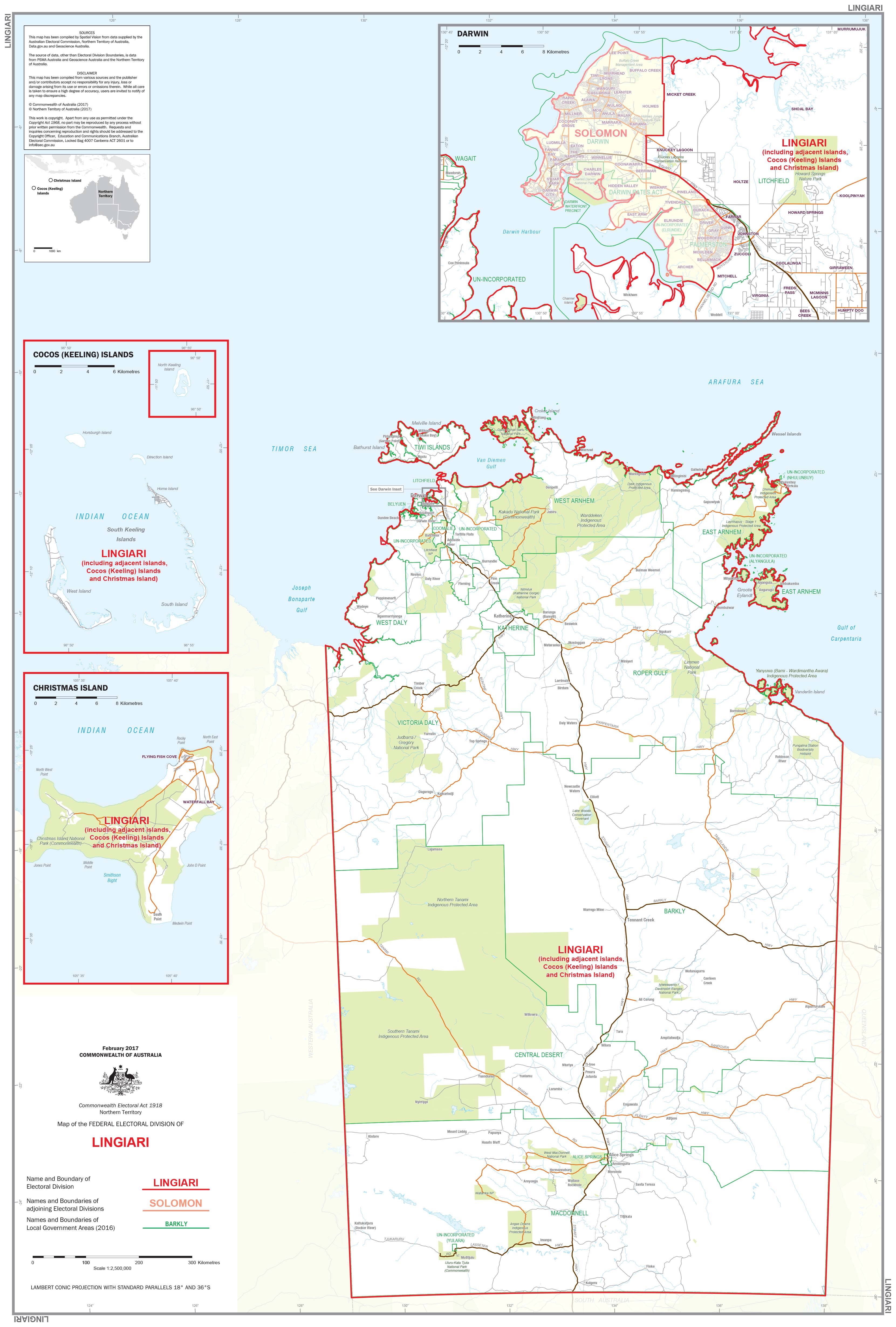
Northern Territory Federal Electoral Divisions and Local Government Areas Map
$59.95
or make 4 interest-free payments of
$14.99 AUD
fortnightly with
![]() More info
More info
Northern Territory — Federal Electoral Divisions & Local Government Areas Map (Lingiari)
Your definitive reference to the NT’s political and administrative boundaries. This professional wall map clearly presents the federal electoral division of Lingiari and all NT Local Government Areas (LGAs)—ideal for government teams, campaign strategists, researchers, educators, businesses, and community organisations.
🗝️ Key Features
-
Federal electoral coverage: Precise boundary mapping for Lingiari—one of the world’s largest single-member divisions—covering NT outside Darwin, including remote communities, pastoral leases, and Aboriginal lands.
-
All LGAs shown: Every Local Government Area across the NT is labelled with clean, readable cartography.
-
Current data: Designed to reflect up-to-date electoral and LGA boundaries.
-
Large-format clarity: High legibility for meeting rooms, control rooms, classrooms, and offices.
🗺️ What This Map Shows
-
Federal Electoral Division: Full extent of Lingiari, with clearly marked boundaries.
-
Local Government Areas: Names and borders for all NT councils, from remote community councils to regional municipalities.
🎨 Materials & Finishes
📄 Paper (160 gsm FSC Matte-Coated)
-
Archival, glare-free surface that preserves fine boundary lines and colours.
-
Best for framing under glass or archival use.
💧 Laminated (True Encapsulation)
-
Printed on 120 gsm stock and encapsulated between two 80-micron gloss films.
-
Waterproof, tear-resistant, wipe-clean; use whiteboard markers and map dots.
-
Built for high-use environments (campaign HQs, planning teams, classrooms).
🪵 Laminated + Timber Hang Rails
-
The laminated map, professionally mounted with natural lacquered timber rails (top & bottom).
-
Includes a strong top hanging cord for quick, tidy wall display.
-
⚠️ Custom-finished: please allow up to 10 working days for delivery.
🎨 Canvas (395 gsm HP Professional Matte)
-
Museum-grade matte canvas for a refined, durable presentation.
-
Printed with pigment-based, fade-resistant inks for long-term clarity and colour stability.
-
Ideal for boardrooms, libraries, and reception spaces.
🪵 Canvas + Timber Hang Rails
-
Canvas map fitted with lacquered timber battens (top & bottom) and a top hanging cord.
-
Creates a gallery-quality, ready-to-hang display.
-
⚠️ Custom-finished: please allow up to 10 working days for delivery.
🧩 Customisation
Need more focus? We can produce individual detailed maps of each electoral division on request. Contact us for scope, pricing, and lead times.
📐 Specifications
| Attribute | Details |
|---|---|
| Title | Northern Territory Federal Electoral Divisions & Local Government Areas Map — Lingiari |
| Coverage | Entire division of Lingiari & all NT Local Government Areas |
| Size | 1000 mm (W) × 700 mm (H) |
| Format Options | Paper; Laminated; Laminated + Timber Hang Rails; Canvas; Canvas + Timber Hang Rails |
| Paper | 160 gsm FSC matte-coated |
| Laminate | 2 × 80-micron gloss (true encapsulation) |
| Canvas | 395 gsm HP Professional Matte |
| Inks | Pigment-based, fade-resistant |
| Delivery | Made to order — 5–7 working days (Paper/Laminated). Up to 10 working days for hang-railed finishes |
| Made in | Australia |
✅ Why Choose This Map?
-
Detailed electoral & LGA boundaries → Clear, current reference for NT planning and analysis
-
High-quality materials → Excellent print clarity and long service life
-
Easy to annotate (laminated) → Perfect with whiteboard pens and map dots
-
Local production → Proudly designed and printed in Australia
-
Custom options → Tailored maps for focused projects or reporting
🛒 Bring clarity and confidence to your NT planning, teaching, research, or strategy. Order the Northern Territory Electoral & LGA Map (Lingiari) today in Paper, Laminated, Laminated + Hang Rails, Canvas, or Canvas + Hang Rails.
Frequently Asked Questions
Where can I buy the Northern Territory Federal Electoral Divisions and Local Government Ar?
The Northern Territory Federal Electoral Divisions and Local Government Ar is available to buy online from Mapworld, Australia's largest map and geographic product retailer, with fast shipping Australia-wide.
Is the Northern Territory Federal Electoral Divisions and Local Government Ar in stock at Mapworld?
Mapworld maintains extensive stock across its map range and aims for fast dispatch. Orders placed before 2pm AEST on business days are typically dispatched the same day, with standard and express Australia-wide delivery options available.
What is Mapworld's returns policy?
Mapworld accepts returns on undamaged items in original condition. Contact Mapworld within 90 days of purchase to arrange a return or exchange.
Does Mapworld ship the Northern Territory Federal Electoral Divisions and Local Government Ar across Australia?
Yes, Mapworld ships Australia-wide. Standard shipping is a flat $7 rate, with free standard shipping on orders over $75. Express options are available at checkout. Most orders placed before 2pm AEST on weekdays are dispatched same day.
Related Items

© 2026 Mapworld. Website designed by Genie Media
X