- Australia ▾
- Topographic
▾
- Australia AUSTopo 250k (2025)
- Australia 50k Geoscience maps
- Australia 100k Geoscience maps
- Australia 250k Geoscience maps
- Australia 1:1m Geoscience maps
- New Zealand 50k maps
- New Zealand 250k maps
- New South Wales 25k maps
- New South Wales 50k maps
- New South Wales 100k maps
- Queensland 10k maps
- Queensland 25k maps
- Queensland 50k maps
- Queensland 100k maps
- Compasses
- Software
- GPS Systems
- Orienteering
- International ▾
- Wall Maps
▾
- World
- Australia & New Zealand
- Countries, Continents & Regions
- Historical
- Vintage National Geographic
- Australian Capital Territory
- New South Wales
- Northern Territory
- Queensland
- South Australia
- Tasmania
- Victoria
- Western Australia
- Celestial
- Children's
- Mining & Resources
- Wine Maps
- Healthcare
- Postcode Maps
- Electoral Maps
- Nautical ▾
- Flags
▾
- Australian Flag Sets & Banners
- Flag Bunting
- Handwavers
- Australian National Flags
- Aboriginal Flags
- Torres Strait Islander Flags
- International Flags
- Flagpoles & Accessories
- Australian Capital Territory Flags
- New South Wales Flags
- Northern Territory Flags
- Queensland Flags
- South Australia Flags
- Tasmania Flags
- Victoria Flags
- Western Australia Flags
- Gifts ▾
- Globes ▾
Dear valued customer. Please note that our checkout is not supported by old browsers. Please use a recent browser to access all checkout capabilities


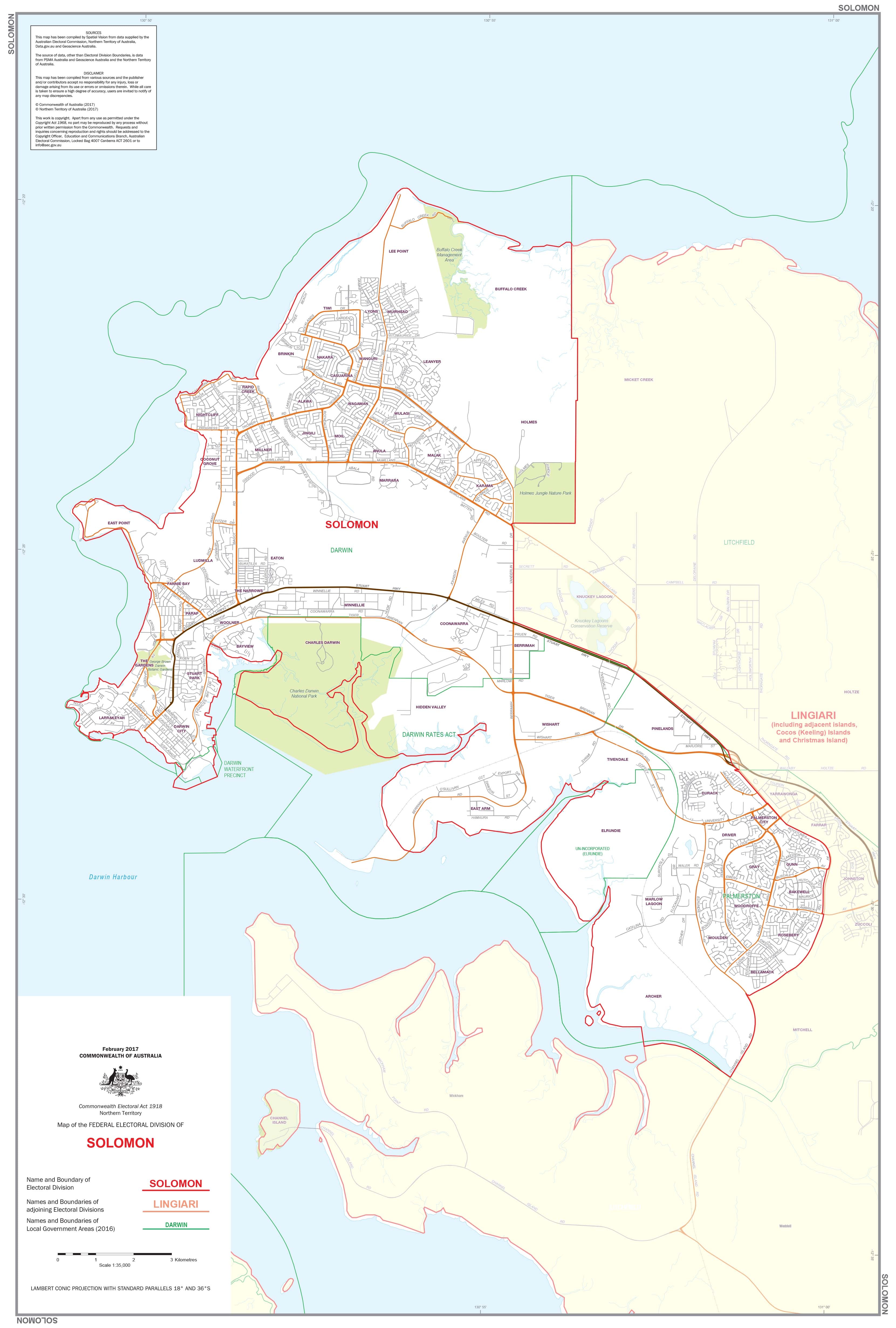
Northern Territory Federal Electoral Divisions and Local Government Areas Map - Solomon
$59.95
or make 4 interest-free payments of
$14.99 AUD
fortnightly with
![]() More info
More info
Northern Territory — Federal Electoral Divisions & Local Government Areas Map (Solomon)
A clear, professional wall map highlighting the federal electoral division of Solomon and all Local Government Areas (LGAs) within its coverage around Darwin. Designed for accuracy and readability, it’s ideal for government teams, campaign offices, educators, researchers, businesses, and community organisations.
🗝️ Key Features
-
Electoral boundary clarity: Precise mapping for Solomon with division name and boundary lines clearly delineated.
-
Local Government Areas shown: All relevant LGA names and borders labelled for quick reference.
-
Up-to-date design: Created to reflect current electoral and LGA boundaries.
-
Large-format readability: Clean cartography for boardrooms, classrooms, and offices.
🗺️ Coverage
-
Federal Division: Solomon
-
Includes: Electoral division boundary plus LGA boundaries & names across the Darwin region.
🎨 Materials & Finishes
📄 Paper (160 gsm Matte)
-
Archival, glare-free stock that preserves fine boundary lines and colours.
-
Best for framing under glass or archival use.
💧 Laminated (True Encapsulation)
-
Encapsulated in 2 × 80-micron gloss laminate over robust print stock.
-
Waterproof, tear-resistant, wipe-clean; use whiteboard markers and map dots.
-
Built for high-use environments (campaign HQs, planning offices, classrooms).
🪵 Laminated + Timber Hang Rails
-
Laminated map mounted with natural lacquered timber rails (top & bottom).
-
Strong top hanging cord for quick, tidy wall display.
-
⚠️ Custom-finished: please allow up to 10 working days for delivery.
🎨 Canvas (395 gsm HP Professional Matte)
-
Museum-grade matte canvas for a refined, durable presentation.
-
Printed with pigment-based, fade-resistant inks for long-term clarity.
🪵 Canvas + Timber Hang Rails
-
Canvas version fitted with lacquered timber battens (top & bottom) and top hanging cord.
-
A gallery-quality, ready-to-hang display.
-
⚠️ Custom-finished: please allow up to 10 working days for delivery.
🧩 Customisation
Need deeper focus? We can produce individual detailed maps of any electoral division on request. Contact us for scope, pricing, and lead times.
📐 Size
-
1000 mm (W) × 700 mm (H)
-
Orientation: Landscape
📊 Specifications
| Attribute | Details |
|---|---|
| Title | Northern Territory Federal Electoral Divisions & Local Government Areas Map — Solomon |
| Coverage | Federal division of Solomon with LGA boundaries & names |
| Size | 1000 × 700 mm |
| Format Options | Paper; Laminated; Laminated + Timber Hang Rails; Canvas; Canvas + Timber Hang Rails |
| Paper | 160 gsm archival matte |
| Laminate | 2 × 80-micron gloss (true encapsulation) |
| Canvas | 395 gsm HP Professional Matte |
| Inks | Pigment-based, fade-resistant |
| Delivery | Paper/Laminated: typically 5–7 working days; Hang-railed finishes: up to 10 working days |
| Made in | Australia |
🎯 Who it’s for
-
🏛️ Government & electoral offices — boundary planning and reference
-
🗳️ Political campaign teams — strategy, outreach, and resourcing
-
🎓 Schools & universities — civics, geography, and political studies
-
🏢 Businesses & planners — service areas and council engagement
-
📍 Community organisations — clear, reliable boundary reference
🤝 Our Commitment
Every map is printed and finished locally in Australia with archival-grade materials and fade-resistant inks. Each copy is colour-managed, hand-checked, and professionally packed, ensuring accuracy, durability, and display-ready quality.
🛒 Order your NT Electoral & LGA Map (Solomon) today — a precise, durable, and beautifully presented reference for Darwin’s federal and local boundaries.
Frequently Asked Questions
Where can I buy the Northern Territory Federal Electoral Divisions and Local Government Ar?
The Northern Territory Federal Electoral Divisions and Local Government Ar is available to buy online from Mapworld, Australia's largest map and geographic product retailer, with fast shipping Australia-wide.
Is the Northern Territory Federal Electoral Divisions and Local Government Ar in stock at Mapworld?
Mapworld maintains extensive stock across its map range and aims for fast dispatch. Orders placed before 2pm AEST on business days are typically dispatched the same day, with standard and express Australia-wide delivery options available.
What is Mapworld's returns policy?
Mapworld accepts returns on undamaged items in original condition. Contact Mapworld within 90 days of purchase to arrange a return or exchange.
Does Mapworld ship the Northern Territory Federal Electoral Divisions and Local Government Ar across Australia?
Yes, Mapworld ships Australia-wide. Standard shipping is a flat $7 rate, with free standard shipping on orders over $75. Express options are available at checkout. Most orders placed before 2pm AEST on weekdays are dispatched same day.
Related Items

© 2026 Mapworld. Website designed by Genie Media
X