- Australia ▾
- Topographic
▾
- Australia AUSTopo 250k (2025)
- Australia 50k Geoscience maps
- Australia 100k Geoscience maps
- Australia 250k Geoscience maps
- Australia 1:1m Geoscience maps
- New Zealand 50k maps
- New Zealand 250k maps
- New South Wales 25k maps
- New South Wales 50k maps
- New South Wales 100k maps
- Queensland 10k maps
- Queensland 25k maps
- Queensland 50k maps
- Queensland 100k maps
- Compasses
- Software
- GPS Systems
- Orienteering
- International ▾
- Wall Maps
▾
- World
- Australia & New Zealand
- Countries, Continents & Regions
- Historical
- Vintage National Geographic
- Australian Capital Territory
- New South Wales
- Northern Territory
- Queensland
- South Australia
- Tasmania
- Victoria
- Western Australia
- Celestial
- Children's
- Mining & Resources
- Wine Maps
- Healthcare
- Postcode Maps
- Electoral Maps
- Nautical ▾
- Flags
▾
- Australian Flag Sets & Banners
- Flag Bunting
- Handwavers
- Australian National Flags
- Aboriginal Flags
- Torres Strait Islander Flags
- International Flags
- Flagpoles & Accessories
- Australian Capital Territory Flags
- New South Wales Flags
- Northern Territory Flags
- Queensland Flags
- South Australia Flags
- Tasmania Flags
- Victoria Flags
- Western Australia Flags
- Gifts ▾
- Globes ▾
Dear valued customer. Please note that our checkout is not supported by old browsers. Please use a recent browser to access all checkout capabilities


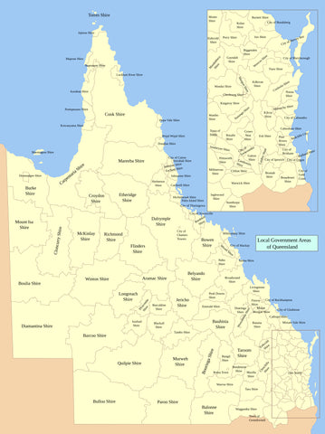
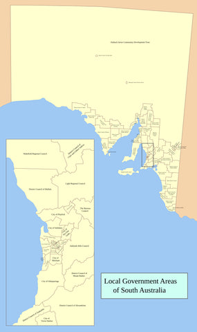
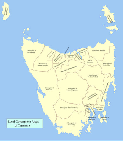
Northern Territory Local Government Areas Wall Map
$69.95
or make 4 interest-free payments of
$17.49 AUD
fortnightly with
![]() More info
More info
Northern Territory Local Government Areas — Administrative Wall Map
1000 × 735 mm • Paper / Laminated / Laminated + Hang Rails / Canvas / Canvas + Hang Rails • Printed in Australia
A clear, wall-readable reference of every Local Government Area (LGA) in the Northern Territory—designed for councils, offices, classrooms, and planning spaces where administrative boundaries and names need to be seen at a glance.
🧭 At a Glance (What’s on the Map)
-
All NT LGA boundaries & names presented with clarity
-
Legend, scale bar & neatline for quick reference
-
Territory-wide context to position each LGA within the NT
-
Wall-readable labelling—clean fonts designed for visibility
-
Contextual features—coastlines, adjoining state borders and key waterbodies
🎯 Why This Map Works
-
Administrative clarity — instantly identify LGAs for planning, funding and service delivery
-
Planning-ready — supports infrastructure, utilities, health, and education zoning
-
Professional presentation — streamlined design suited for offices and public display
-
Durable choices — select from hard-wearing laminate for daily handling or canvas for a refined display finish
👥 Who Uses It
-
Local & Territory Government — councillor briefings, planning and consultations
-
Utilities & Logistics — service coverage, remote community planning
-
Healthcare & Education — regional catchments, resource allocation
-
Real Estate & Media — reporting regions and marketing territories
-
Libraries & Community Centres — a reference for visitors and the public
🧩 Design Details
-
Boundary hierarchy — LGAs outlined distinctly with Territory boundary reinforced
-
Legible labelling — clear, consistent fonts sized for wall readability
-
Balanced colour palette — separates regions without clutter
-
Cartographic consistency — legend, scale bar and neatline carefully aligned
🎨 Finishes & Display Options
-
📄 Paper — Heavyweight 160 gsm (Matte)
Smooth, low-glare stock ideal for framing under glass. -
💧 Laminated — True Encapsulation
Printed on 120 gsm and sealed in 2 × 80-micron gloss laminate (edge-sealed).
Wipe-clean • Tear-resistant • Moisture-safe — use non-permanent whiteboard markers and map dots. -
🪵 Laminated + Timber Hang Rails — Ready to Hang
Natural lacquered timber rails (top & bottom) with a top hanging cord for a polished, frame-free finish.
⏱️ Custom finish — please allow up to 10 working days for rail fitting. -
🖼️ Canvas — HP 395 gsm Professional Matte
Gallery-grade canvas printed with pigment-based, fade-resistant inks for exceptional detail. -
🪵 Canvas + Timber Hang Rails
Same premium canvas, finished with natural timber rails and top hanging cord.
⏱️ Custom finish — please allow up to 10 working days for rail fitting.
Dry-erase markers recommended only on laminated versions.
📐 Specifications
| Attribute | Details |
|---|---|
| Title | Northern Territory Local Government Areas — Administrative Wall Map |
| Coverage | Northern Territory, Australia |
| Map Type | Administrative (Local Government Areas) |
| Size | 1000 mm (H) × 735 mm (W) |
| Scale | Not stated |
| Formats | Paper • Laminated • Laminated + Hang Rails • Canvas • Canvas + Hang Rails |
| Paper | 160 gsm matte |
| Laminate | 2 × 80-micron gloss, true encapsulation (edge-sealed) |
| Canvas | HP 395 gsm Professional Matte |
| Inks | Pigment-based, fade-resistant |
| Origin | Printed in Australia |
| Lead Time | Hang-railed finishes: up to 10 working days |
🧽 Mounting & Care
-
Laminated: Use non-permanent whiteboard markers; wipe with a dry microfibre cloth.
-
Paper: Frame under glass to ensure longevity.
-
Canvas: Dust lightly; avoid liquids and prolonged direct sunlight.
-
Hanging tip: For rail versions, use a centred wall hook and allow the map to hang naturally.
🤝 Our Commitment
-
Australian made: Designed, printed, and finished locally.
-
Premium quality: Archival pigment inks and professional-grade materials.
-
Packed with care: Hand-checked and shipped securely to arrive clean and display-ready.
See the Northern Territory’s LGAs in clear detail.
Choose your finish and add this essential administrative map to your wall.
Frequently Asked Questions
What are the dimensions of the Northern Territory Local Government Areas Wall Map?
Mapworld wall maps range from standard 700×1000mm to large-format 1000×1430mm Supermaps. The exact dimensions for this map are shown in the product title. Where multiple sizes are available, select your preferred size when adding to cart.
Is this wall map available laminated?
Many Mapworld wall maps are available in paper, laminated, or framed finishes. Check the product options when adding to cart. Laminated maps are wipe-clean and more durable.
Is this the latest edition?
Mapworld stocks the most current editions available from all publishers. Edition year is shown in the product title where applicable. Mapworld updates its catalogue as new editions are released.
Can I write on or pin this wall map?
Laminated wall maps can be written on with whiteboard markers and wiped clean. Paper maps can be pinned on a corkboard. Choose a laminated option for a writeable surface.
Does Mapworld ship the Northern Territory Local Government Areas Wall Map across Australia?
Yes, Mapworld ships Australia-wide. Standard shipping is a flat $7 rate, with free standard shipping on orders over $75. Express options are available at checkout. Most orders placed before 2pm AEST on weekdays are dispatched same day.
Related Items

© 2026 Mapworld. Website designed by Genie Media
X