- Australia ▾
- Topographic
▾
- Australia AUSTopo 250k (2025)
- Australia 50k Geoscience maps
- Australia 100k Geoscience maps
- Australia 250k Geoscience maps
- Australia 1:1m Geoscience maps
- New Zealand 50k maps
- New Zealand 250k maps
- New South Wales 25k maps
- New South Wales 50k maps
- New South Wales 100k maps
- Queensland 10k maps
- Queensland 25k maps
- Queensland 50k maps
- Queensland 100k maps
- Western Australia 25k maps
- Western Australia 50k maps
- Western Australia 100k maps
- Compasses
- Software
- GPS Systems
- International ▾
- Wall Maps
▾
- World
- Australia & New Zealand
- Countries, Continents & Regions
- Historical
- Vintage National Geographic
- Australian Capital Territory
- New South Wales
- Northern Territory
- Queensland
- South Australia
- Tasmania
- Victoria
- Western Australia
- Celestial
- Children's
- Mining & Resources
- Wine Maps
- Healthcare
- Postcode Maps
- Electoral Maps
- Nautical ▾
- Flags
▾
- Australian Flag Sets & Banners
- Flag Bunting
- Handwavers
- Australian National Flags
- Aboriginal Flags
- Torres Strait Islander Flags
- International Flags
- Flagpoles & Accessories
- Australian Capital Territory Flags
- New South Wales Flags
- Northern Territory Flags
- Queensland Flags
- South Australia Flags
- Tasmania Flags
- Victoria Flags
- Western Australia Flags
- Gifts ▾
- Globes ▾
Dear valued customer. Please note that our checkout is not supported by old browsers. Please use a recent browser to access all checkout capabilities


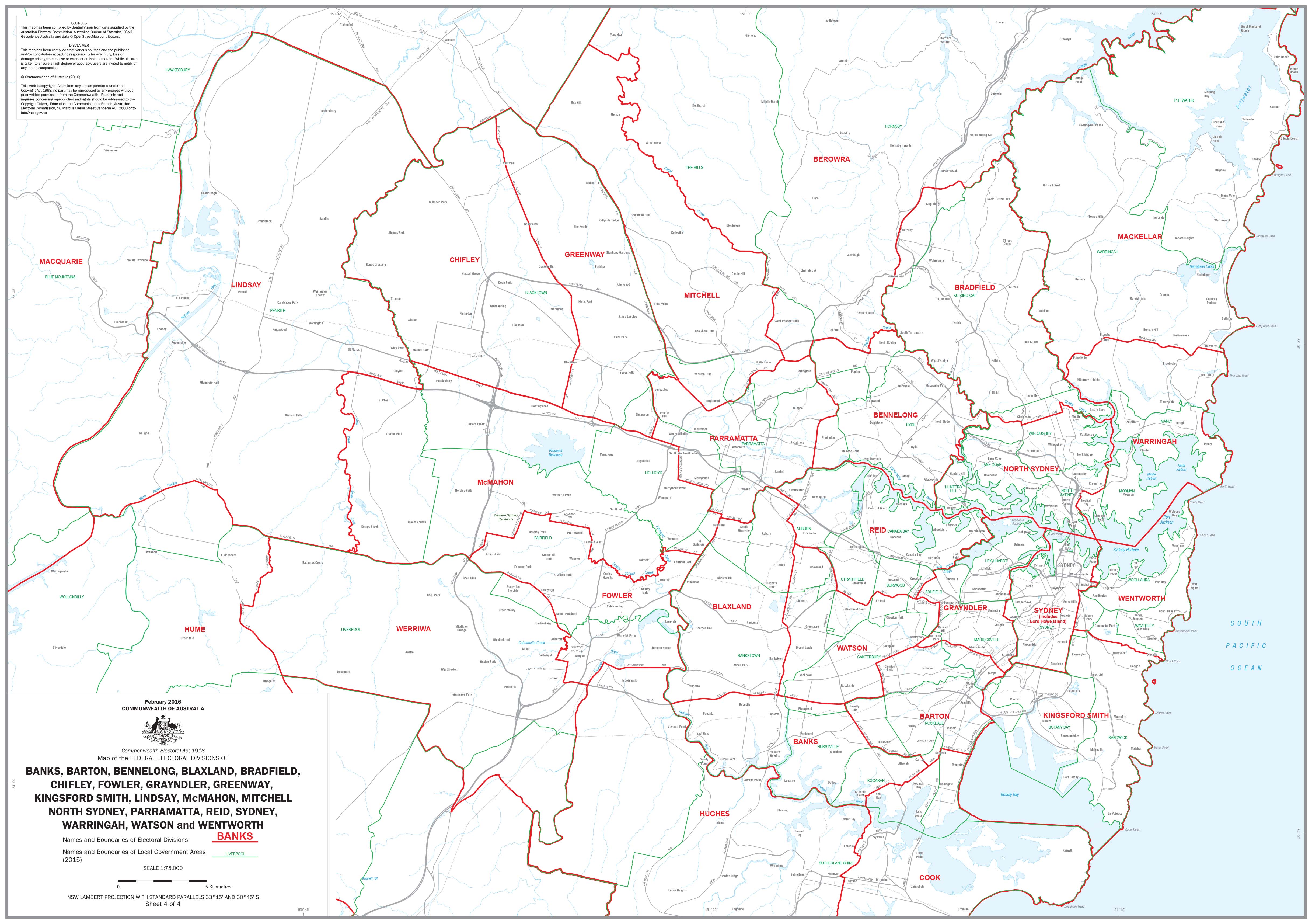
New South Wales Federal Electoral Divisions and Local Government Areas Map - Sydney & Area
$59.95
or make 4 interest-free payments of
$14.99 AUD
fortnightly with
![]() More info
More info
New South Wales — Federal Electoral Divisions & Local Government Areas Map (Sydney & Surrounds)
The New South Wales Federal Electoral Divisions and Local Government Areas Map provides a detailed and up-to-date view of Sydney and its surrounding regions. Designed for clarity, it shows federal electoral boundaries alongside local government area (LGA) boundaries, making it an invaluable reference for government, education, business, and community use.
Covering the Sydney metropolitan area and surrounding districts, this large-format wall map combines electoral geography with local administration — ideal for planning, analysis, or display.
🗝️ Key Features
-
Federal electoral divisions — Boundaries clearly marked across Sydney and surrounding areas
-
Local government areas — All LGAs distinguished with clear labelling
-
Comprehensive coverage — Focus on the Sydney metro region and adjoining districts
-
Practical for planning — Essential for government agencies, political offices, schools, and businesses
-
Large-format design — Easy to read at a glance, suitable for offices and classrooms
🎨 Materials & Finish
-
📄 Paper (160 gsm matte): Archival-quality, perfect for framing under glass.
-
💧 Laminated (True Encapsulation): 2 × 80-micron gloss laminate, waterproof, tear-resistant, and wipe-clean.
-
🪵 Laminated + Timber Hang Rails: Professionally mounted with natural lacquered timber rails and hanging cord; ready to display.
-
🎨 Canvas (395 gsm HP Professional Matte): Printed on museum-grade canvas with pigment-based inks for a premium, durable finish.
-
🪵 Canvas + Timber Hang Rails: Gallery-quality presentation with canvas mounted in lacquered timber rails; ready to hang.
⚠️ Please allow up to 10 working days for delivery of hang-railed maps, as each is custom-finished by our framer.
📐 Size
-
Dimensions: 1000 mm (w) x 700 mm (h)
-
Orientation: Portrait
📊 Specifications
| Attribute | Details |
|---|---|
| Title | NSW Federal Electoral Divisions & Local Government Areas — Sydney & Area |
| Coverage | Sydney metropolitan region and adjoining areas |
| Features | Federal electoral boundaries, local government areas, clear labels |
| Format Options | Paper, Laminated, Laminated + Timber Hang Rails, Canvas, Canvas + Timber Hang Rails |
| Paper Weight | 160 gsm archival matte |
| Laminate | 2 × 80-micron gloss (true encapsulation) |
| Canvas | 395 gsm HP Professional Matte |
| Inks | Pigment-based, fade-resistant |
| Optional Hang Rails | Natural timber, lacquered; top cord included |
| Origin | Printed in Australia |
🎯 Who it’s for
-
🏛️ Government & electoral offices — Electoral planning and analysis
-
🏢 Businesses & community organisations — Understanding local government areas
-
🎓 Schools & universities — Teaching civics, geography, and political studies
-
📍 Community groups & researchers — Clear boundary reference for projects and reports
🤝 Our Commitment
All maps are printed and finished locally in Australia, using archival-quality materials and fade-resistant inks. Each copy is hand-checked, carefully packed, and professionally finished, ensuring it arrives ready for reference or display.
🛒 Order your NSW Federal Electoral Divisions & Local Government Areas Map (Sydney & Area) today — a clear and authoritative guide to Sydney’s electoral and local government boundaries.
Frequently Asked Questions
Where can I buy the New South Wales Federal Electoral Divisions and Local Government Areas?
The New South Wales Federal Electoral Divisions and Local Government Areas is available to buy online from Mapworld, Australia's largest map and geographic product retailer, with fast shipping Australia-wide.
Is the New South Wales Federal Electoral Divisions and Local Government Areas in stock at Mapworld?
Mapworld maintains extensive stock across its map range and aims for fast dispatch. Orders placed before 2pm AEST on business days are typically dispatched the same day, with standard and express Australia-wide delivery options available.
What is Mapworld's returns policy?
Mapworld accepts returns on undamaged items in original condition. Contact Mapworld within 90 days of purchase to arrange a return or exchange.
Does Mapworld ship the New South Wales Federal Electoral Divisions and Local Government Areas across Australia?
Yes, Mapworld ships Australia-wide. Standard shipping is a flat $7 rate, with free standard shipping on orders over $75. Express options are available at checkout. Most orders placed before 2pm AEST on weekdays are dispatched same day.
Related Items

© 2026 Mapworld. Website designed by Genie Media
X