- Australia ▾
- Topographic
▾
- Australia AUSTopo 250k (2025)
- Australia 50k Geoscience maps
- Australia 100k Geoscience maps
- Australia 250k Geoscience maps
- Australia 1:1m Geoscience maps
- New Zealand 50k maps
- New Zealand 250k maps
- New South Wales 25k maps
- New South Wales 50k maps
- New South Wales 100k maps
- Queensland 10k maps
- Queensland 25k maps
- Queensland 50k maps
- Queensland 100k maps
- Western Australia 25k maps
- Western Australia 50k maps
- Western Australia 100k maps
- Compasses
- Software
- GPS Systems
- International ▾
- Wall Maps
▾
- World
- Australia & New Zealand
- Countries, Continents & Regions
- Historical
- Vintage National Geographic
- Australian Capital Territory
- New South Wales
- Northern Territory
- Queensland
- South Australia
- Tasmania
- Victoria
- Western Australia
- Celestial
- Children's
- Mining & Resources
- Wine Maps
- Healthcare
- Postcode Maps
- Electoral Maps
- Nautical ▾
- Flags
▾
- Australian Flag Sets & Banners
- Flag Bunting
- Handwavers
- Australian National Flags
- Aboriginal Flags
- Torres Strait Islander Flags
- International Flags
- Flagpoles & Accessories
- Australian Capital Territory Flags
- New South Wales Flags
- Northern Territory Flags
- Queensland Flags
- South Australia Flags
- Tasmania Flags
- Victoria Flags
- Western Australia Flags
- Gifts ▾
- Globes ▾
Dear valued customer. Please note that our checkout is not supported by old browsers. Please use a recent browser to access all checkout capabilities


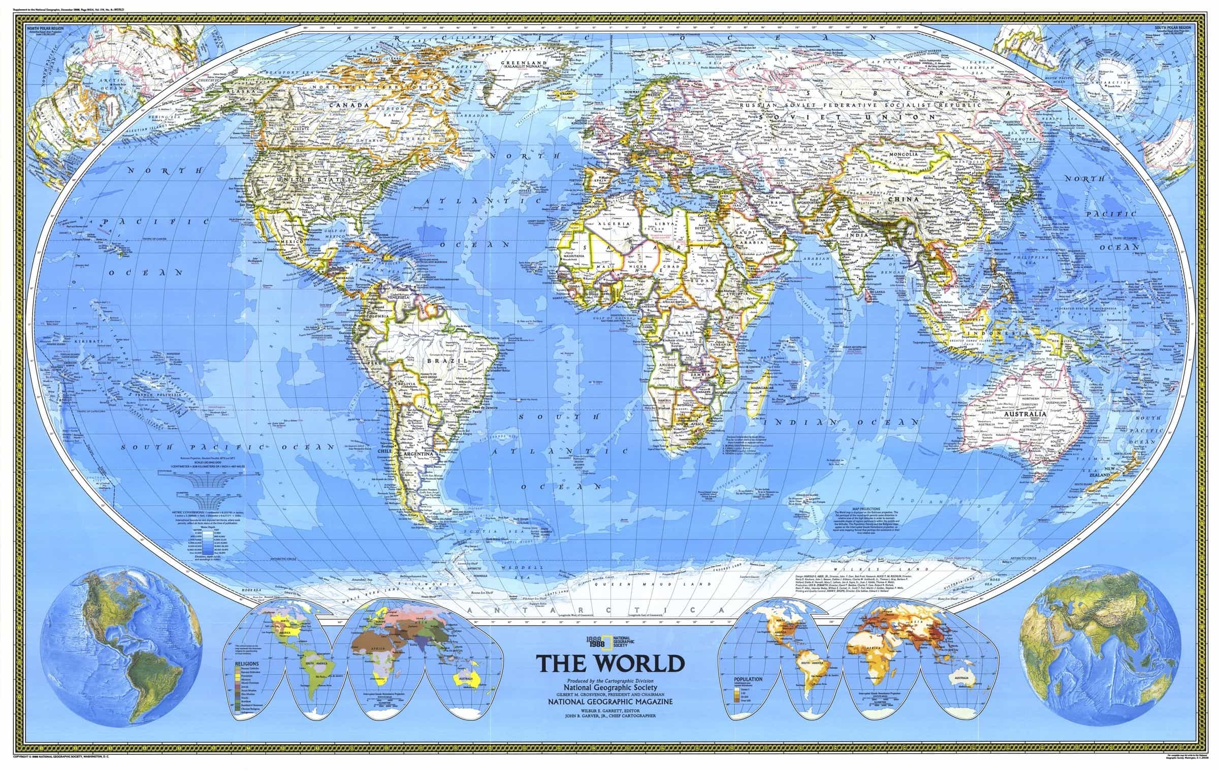
World Wall Map 1988 by National Geographic
$79.95
or make 4 interest-free payments of
$19.99 AUD
fortnightly with
![]() More info
More info
Borders, Relief & Cultures — World Wall Map (1988)
A snapshot of the late–20th-century world, rendered with clarity and restraint. Published by National Geographic in December 1988 (the Society’s centennial), this world sheet blends vivid political boundaries with rich physical geography and timely cultural insets. Thousands of place names (including capitals), relief shading across land and sea, and dramatic Eastern/Western Hemisphere physical panels are set out in clean, legible cartography that rewards both room-distance viewing and close study. It’s the fabric of a connected planet—ordered, comparative, and unmistakably of its era—made to study, admire, and display.
More Than a Map – A Testament to History
This isn’t just wall art—it’s a comprehensive portrait of Earth at the close of the 1980s. Explore Arctic and Antarctic insets, compare global patterns through Population and Religions of the World panels, and read terrain at a glance via expressive relief shading. Ideal for educators, planners, historians, designers, and collectors, this sheet pairs beautifully with earlier and later National Geographic world maps for a powerful then-and-now display.
Hang it in studios, libraries, classrooms, museums, offices, or at home to invite reflection, study, and conversation.
Premium Materials & Finishes
We treat history with the respect it deserves. That’s why we offer multiple formats, each produced using high-quality materials and modern archival printing.
🌟 Archival Paper Print
Printed on heavyweight 160gsm archival-grade paper.
Smooth matte finish reduces glare and preserves fine linework and small labels.
Ideal for framing under glass—clean, timeless, and built to last.
💎 Laminated Edition
Encapsulated in two sheets of 80-micron gloss laminate using true thermal bonding—not just surface lamination.
Moisture-resistant, wipe-clean surface—perfect for classrooms and high-traffic reference spaces.
Optional Natural Timber Hang Rails: lacquered rails with a fitted hanging cord provide a polished, ready-to-hang presentation—no frame required. (Please allow up to 10 working days for delivery with hang rails.)
🏆 Museum-Quality Canvas
Printed on heavyweight 395gsm HP Professional Matte Canvas for rich texture and exceptional strength.
Pigment-based, fade-resistant inks deliver deep tone and crisp typography that endure for generations.
Optional Natural Timber Hang Rails: lacquered to enhance the wood grain and protect against wear; top cord for effortless hanging—elegant in any setting. (Please allow up to 10 working days for delivery with hang rails.)
Specifications
| Feature | Details |
|---|---|
| Title | World Wall Map |
| Series | National Geographic single-sheet world map |
| Original Publication | 1988 (December, centennial issue) |
| Scale | Not specified |
| Cartographic Content | Vivid borders; thousands of place names incl. capitals; relief shading; Arctic & Antarctic insets; dramatic Eastern & Western Hemisphere physical insets; Population inset; Religions of the World inset |
| Map Size | 1166 mm (W) × 737 mm (H) |
| Available Formats | Paper, Laminated, Canvas |
| Paper Weight | 160gsm archival-quality |
| Laminate | 2 × 80-micron gloss laminate sheets (encapsulated) |
| Canvas Weight | 395gsm HP Professional Matte Canvas |
| Inks | Pigment-based, fade-resistant |
| Optional Hang Rails | Available on Laminated & Canvas (lead time up to 10 working days) |
| Origin | Made in Australia |
Why Choose This Map
✔ Era-True Snapshot: Borders and global context exactly as presented in 1988.
✔ Layered Insight: Population and religion insets add cultural depth to political and physical views.
✔ Polar & Physical Focus: Arctic/Antarctic and hemisphere relief panels make landforms instantly legible.
✔ Clarity at Scale: Classic National Geographic styling with dense, readable detail.
✔ Archival Craft: Premium substrates and inks preserve contrast, labels, and linework for decades.
Our Commitment
We believe that preserving history is as important as telling it. Every map is printed locally in Australia using state-of-the-art technology, carefully checked by hand, and packed with care. From the moment it leaves our workshop to the day it hangs on your wall, we ensure quality you can trust and a legacy you’ll be proud to share.
Bring the centennial world into focus. Order the World Wall Map (1988) today—a faithful, beautifully produced sheet that turns a room into a conversation.
Frequently Asked Questions
What are the dimensions of the World Wall Map 1988 by National Geographic?
Mapworld wall maps range from standard 700×1000mm to large-format 1000×1430mm Supermaps. The exact dimensions for this map are shown in the product title. Where multiple sizes are available, select your preferred size when adding to cart.
Is this wall map available laminated?
Many Mapworld wall maps are available in paper, laminated, or framed finishes. Check the product options when adding to cart. Laminated maps are wipe-clean and more durable.
Is this the latest edition?
Mapworld stocks the most current editions available from all publishers. Edition year is shown in the product title where applicable. Mapworld updates its catalogue as new editions are released.
Can I write on or pin this wall map?
Laminated wall maps can be written on with whiteboard markers and wiped clean. Paper maps can be pinned on a corkboard. Choose a laminated option for a writeable surface.
Does Mapworld ship the World Wall Map 1988 by National Geographic across Australia?
Yes, Mapworld ships Australia-wide. Standard shipping is a flat $7 rate, with free standard shipping on orders over $75. Express options are available at checkout. Most orders placed before 2pm AEST on weekdays are dispatched same day.
Related Items


© 2026 Mapworld. Website designed by Genie Media
X