

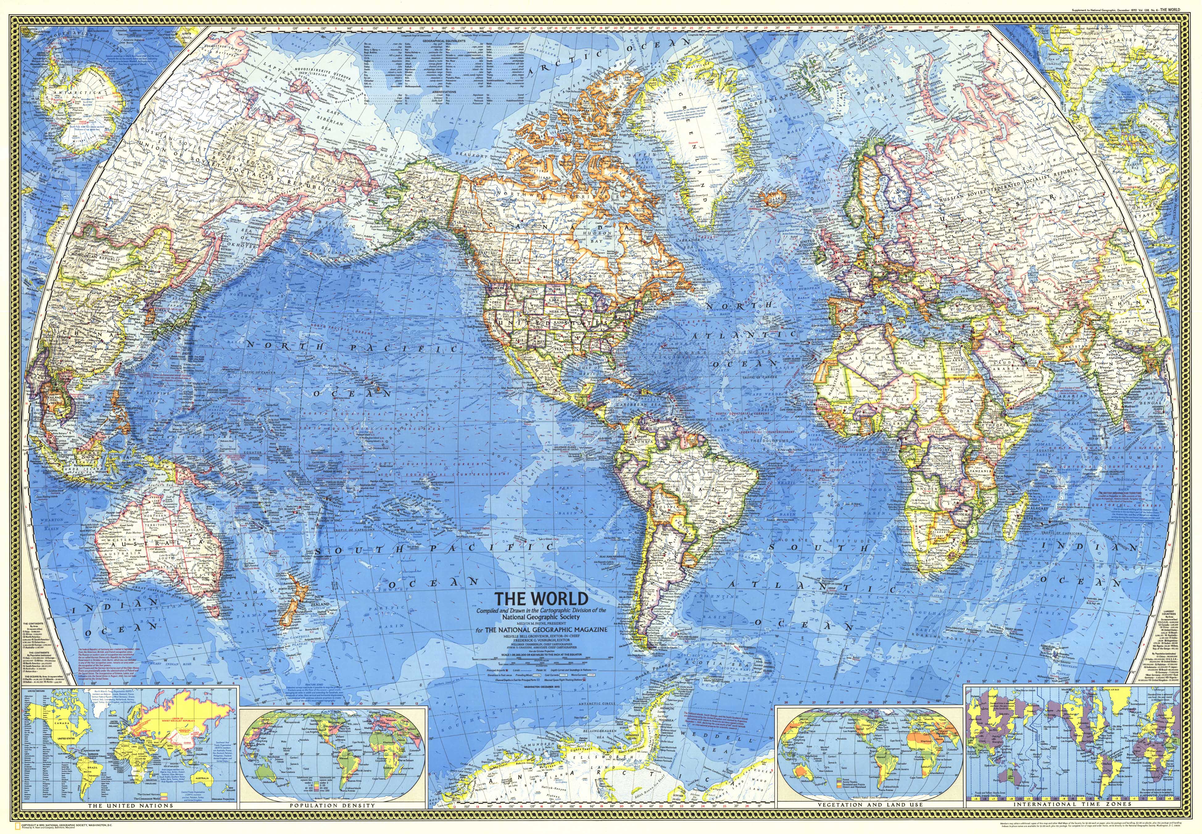
Currents, Countries & Orbits — World Wall Map (1970)
A snapshot of the space-age world, rendered with clarity and restraint. Published by National Geographic in 1970, this world sheet blends vivid political detail with deep physical geography. Country borders, thousands of place names (including capitals), and rich oceanography—depth curves and soundings (in fathoms), warm/cold currents, and prevailing winds—are set out in clean, legible cartography that rewards both room-distance viewing and close study. Timely insets and manned space-flight tracking stations anchor the moment when Earth was being mapped from sea level to low orbit.
More Than a Map – A Testament to History
This isn’t just wall art—it’s a reference frame for the world at the turn of the 1970s. Compare national borders, scan Northern and Southern Hemisphere insets, review United Nations membership, and explore thematic panels for vegetation & land use, population density, and world time zones. Ideal for educators, planners, historians, designers, and collectors, this sheet stands alone beautifully and pairs perfectly with earlier National Geographic world maps for then-and-now comparison.
Hang it in studios, libraries, classrooms, museums, offices, or at home to invite reflection, study, and conversation.
Premium Materials & Finishes
We treat history with the respect it deserves. That’s why we offer multiple formats, each produced using high-quality materials and modern archival printing.
🌟 Archival Paper Print
Printed on heavyweight 160gsm archival-grade paper.
Smooth matte finish reduces glare and preserves fine linework and small labels.
Ideal for framing under glass—clean, timeless, and built to last.
💎 Laminated Edition
Encapsulated in two sheets of 80-micron gloss laminate using true thermal bonding—not just surface lamination.
Moisture-resistant, wipe-clean surface—perfect for classrooms and high-traffic reference spaces.
Optional Natural Timber Hang Rails: lacquered rails with a fitted hanging cord provide a polished, ready-to-hang presentation—no frame required. (Please allow up to 10 working days for delivery with hang rails.)
🏆 Museum-Quality Canvas
Printed on heavyweight 395gsm HP Professional Matte Canvas for rich texture and exceptional strength.
Pigment-based, fade-resistant inks deliver deep tone and crisp typography that endure for generations.
Optional Natural Timber Hang Rails: lacquered to enhance the wood grain and protect against wear; top cord for effortless hanging—elegant in any setting. (Please allow up to 10 working days for delivery with hang rails.)
Specifications
| Feature | Details |
|---|---|
| Title | World Wall Map |
| Series | National Geographic single-sheet world map |
| Original Publication | 1970 |
| Cartographic Content | Vivid borders; thousands of place names incl. capitals; North & South Polar insets; UN countries inset; thematic insets for vegetation & land use, population density, and world time zones; airports; canals; channel depths for principal ports; bathymetry with depth curves & soundings (fathoms); elevations; prevailing winds; warm & cold ocean currents; manned space-flight tracking stations; annotated map notes |
| Map Size | 1072 mm (W) × 746 mm (H) |
| Available Formats | Paper, Laminated, Canvas |
| Paper Weight | 160gsm archival-quality |
| Laminate | 2 × 80-micron gloss laminate sheets (encapsulated) |
| Canvas Weight | 395gsm HP Professional Matte Canvas |
| Inks | Pigment-based, fade-resistant |
| Optional Hang Rails | Available on Laminated & Canvas (lead time up to 10 working days) |
| Origin | Made in Australia |
Why Choose This Map
✔ Era-True Snapshot: Politics, oceans, and space-age infrastructure as mapped in 1970.
✔ Layered Context: UN membership, time zones, and thematic insets deepen understanding at a glance.
✔ Network Insight: Airports, canals, channel depths, currents, and winds connect land and sea.
✔ Clarity at Scale: Classic National Geographic styling with dense, readable detail.
✔ Archival Craft: Premium substrates and inks preserve contrast, labels, and linework for decades.
Our Commitment
We believe that preserving history is as important as telling it. Every map is printed locally in Australia using state-of-the-art technology, carefully checked by hand, and packed with care. From the moment it leaves our workshop to the day it hangs on your wall, we ensure quality you can trust and a legacy you’ll be proud to share.
Bring the space-age world into focus. Order the World Wall Map (1970) today—a faithful, beautifully produced sheet that turns a room into a conversation.


