- Australia ▾
- Topographic
▾
- Australia AUSTopo 250k (2025)
- Australia 50k Geoscience maps
- Australia 100k Geoscience maps
- Australia 250k Geoscience maps
- Australia 1:1m Geoscience maps
- New Zealand 50k maps
- New Zealand 250k maps
- New South Wales 25k maps
- New South Wales 50k maps
- New South Wales 100k maps
- Queensland 10k maps
- Queensland 25k maps
- Queensland 50k maps
- Queensland 100k maps
- Western Australia 25k maps
- Western Australia 50k maps
- Western Australia 100k maps
- Compasses
- Software
- GPS Systems
- International ▾
- Wall Maps
▾
- World
- Australia & New Zealand
- Countries, Continents & Regions
- Historical
- Vintage National Geographic
- Australian Capital Territory
- New South Wales
- Northern Territory
- Queensland
- South Australia
- Tasmania
- Victoria
- Western Australia
- Celestial
- Children's
- Mining & Resources
- Wine Maps
- Healthcare
- Postcode Maps
- Electoral Maps
- Nautical ▾
- Flags
▾
- Australian Flag Sets & Banners
- Flag Bunting
- Handwavers
- Australian National Flags
- Aboriginal Flags
- Torres Strait Islander Flags
- International Flags
- Flagpoles & Accessories
- Australian Capital Territory Flags
- New South Wales Flags
- Northern Territory Flags
- Queensland Flags
- South Australia Flags
- Tasmania Flags
- Victoria Flags
- Western Australia Flags
- Gifts ▾
- Globes ▾
Dear valued customer. Please note that our checkout is not supported by old browsers. Please use a recent browser to access all checkout capabilities


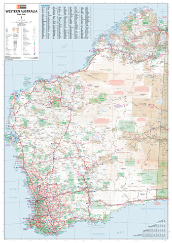
Western Australia Road and 4WD Track Atlas Hema
$49.95
Afterpay is only available for orders between $50.00 and $1000.00 More info
Your ultimate travel companion for navigating the wide-open spaces, rugged landscapes, and remote tracks of Western Australia.
The Western Australia Road & 4WD Track Atlas by Hema Maps is the definitive guide for travellers and off-road adventurers exploring Australia’s largest and most diverse state. This spiral-bound, full-colour atlas offers a wealth of meticulously researched content, blending state-wide road mapping with detailed 4WD route guides, national park information, and essential touring resources.
From the dramatic gorges of Karijini and the pristine beaches of the Coral Coast to the red-dirt tracks of the Kimberley and the tranquil forests of the South West, this atlas ensures you are well-prepared, informed, and inspired for every kilometre of your journey.
🛣️ Key Features & Highlights
🗺️ Detailed Road & 4WD Mapping
-
Features comprehensive WA coverage at 1:250,000 scale
-
Includes off-road tracks, sealed/unsealed roads, and remote access routes
-
Enhanced detail for Perth Metro, South West, and high-traffic regions
-
Track surfaces are colour-coded to indicate difficulty and conditions
🚙 Top 50 4WD Trips
-
Includes detailed write-ups of 50 of the best 4WD adventures across WA
-
Each trip includes:
-
Track grading (difficulty level)
-
Trip distance and duration
-
Track notes and points of interest
-
Access notes and contact details
-
Cross-references to atlas maps
-
Destinations include:
-
Gibb River Road
-
Canning Stock Route
-
Steep Point
-
Holland Track
-
Cape Le Grand to Israelite Bay
-
Dirk Hartog Island and more
Perfect for both seasoned off-roaders and first-time adventurers wanting to test their skills and explore WA’s hidden gems.
🌿 Top 25 National Parks
-
Dedicated park profiles provide:
-
Campground listings and facilities
-
Walking trails and scenic drives
-
Park access roads and 4WD tracks
-
Inset maps and park-specific features
-
Contact details for rangers and visitor centres
-
Parks covered include:
-
Kalbarri, Karijini, Cape Range, Fitzgerald River, Stirling Range, and Purnululu (Bungle Bungles)
🏕️ Camping & Touring Facilities
-
Listings include:
-
Caravan parks
-
Dump points
-
Free and paid campsites
-
Rest stops and truck bays
-
Fuel stations and information centres
-
Also features a full directory of WA-accredited visitor information centres to help you access up-to-date local advice on the road.
📏 Navigation & Planning Tools
-
Comprehensive index of place names for easy look-up
-
GPS-compatible grid references
-
Distance charts and route planning suggestions
-
Elevation shading and contour mapping for terrain awareness
-
Ideal for route plotting, itinerary building, and emergency preparedness
📘 Atlas Specifications
-
Edition: 4th (2024)
-
Publisher: Hema Maps
-
Format: A4 Spiral-bound, durable laminated cover
-
Pages: 211
-
Dimensions: 290 mm (H) × 230 mm (W) × 20 mm (D)
-
Weight: Approx. 950 grams
-
Binding: Lay-flat spiral for easy use on dashboards, camping tables, or map boards
-
Printed in: Australia
🎯 Who It’s For
-
4WD enthusiasts exploring the outback, coastal, and inland tracks of WA
-
Caravaners and campers planning multi-day journeys with access to facilities
-
Adventure travellers seeking self-drive routes to remote and iconic destinations
-
Trip planners and tour operators designing custom WA itineraries
-
Grey nomads, overlanders, and explorers committed to comprehensive, reliable navigation
✅ Why Choose the WA Road & 4WD Track Atlas by Hema?
-
Created by Australia’s most trusted outback mapping specialists
-
Informed by extensive field research and GPS plotting
-
Combines state-level mapping with track-level 4WD guidance in one volume
-
Durable spiral format built to withstand rugged travel conditions
-
Printed in Australia using high-quality stock and binding materials
From red-dirt crossings to turquoise coastlines, dense jarrah forests to desert tracks — Western Australia is built for adventure.
Let the Western Australia Road & 4WD Track Atlas by Hema Maps guide your journey with confidence, clarity, and local expertise.
Explore more. Drive smarter. Discover WA like never before.
Frequently Asked Questions
What does the Western Australia Road and 4WD Track Atlas Hema cover?
This atlas covers the geographic region indicated in the product title, including roads, towns, distances, and key travel information. Mapworld stocks atlases for Australian states and territories, 4WD regions, and international destinations.
Is this the latest edition?
Yes, this is the latest edition. Mapworld stocks the most current editions available from publishers.
Is this atlas or guide spiral bound?
Spiral binding is indicated in the product title where applicable. Spiral-bound atlases and guides lay flat when open, making them ideal for use in vehicles or on a table without needing to hold pages open.
Is the Western Australia Road and 4WD Track Atlas Hema in stock at Mapworld?
Mapworld maintains extensive stock across its map range and aims for fast dispatch. Orders placed before 2pm AEST on business days are typically dispatched the same day, with standard and express Australia-wide delivery options available.
Does Mapworld ship the Western Australia Road and 4WD Track Atlas Hema across Australia?
Yes, Mapworld ships Australia-wide. Standard shipping is a flat $7 rate, with free standard shipping on orders over $75. Express options are available at checkout. Most orders placed before 2pm AEST on weekdays are dispatched same day.
Related Items


© 2026 Mapworld. Website designed by Genie Media
X