- Australia ▾
- Topographic
▾
- Australia AUSTopo 250k (2025)
- Australia 50k Geoscience maps
- Australia 100k Geoscience maps
- Australia 250k Geoscience maps
- Australia 1:1m Geoscience maps
- New Zealand 50k maps
- New Zealand 250k maps
- New South Wales 25k maps
- New South Wales 50k maps
- New South Wales 100k maps
- Queensland 10k maps
- Queensland 25k maps
- Queensland 50k maps
- Queensland 100k maps
- Western Australia 25k maps
- Western Australia 50k maps
- Western Australia 100k maps
- Compasses
- Software
- GPS Systems
- International ▾
- Wall Maps
▾
- World
- Australian Wall Maps
- Countries, Continents & Regions
- Historical
- Vintage National Geographic
- Australian Capital Territory
- New South Wales
- Northern Territory
- Queensland
- South Australia
- Tasmania
- Victoria
- Western Australia
- Celestial
- Children's
- Mining & Resources
- Wine Maps
- Healthcare
- Postcode Maps
- Electoral Maps
- Nautical ▾
- Flags
▾
- Australian Flag Sets & Banners
- Flag Bunting
- Handwavers
- Australian National Flags
- Aboriginal Flags
- Torres Strait Islander Flags
- International Flags
- Flagpoles & Accessories
- Australian Capital Territory Flags
- New South Wales Flags
- Northern Territory Flags
- Queensland Flags
- South Australia Flags
- Tasmania Flags
- Victoria Flags
- Western Australia Flags
- Gifts ▾
- Globes ▾
Dear valued customer. Please note that our checkout is not supported by old browsers. Please use a recent browser to access all checkout capabilities





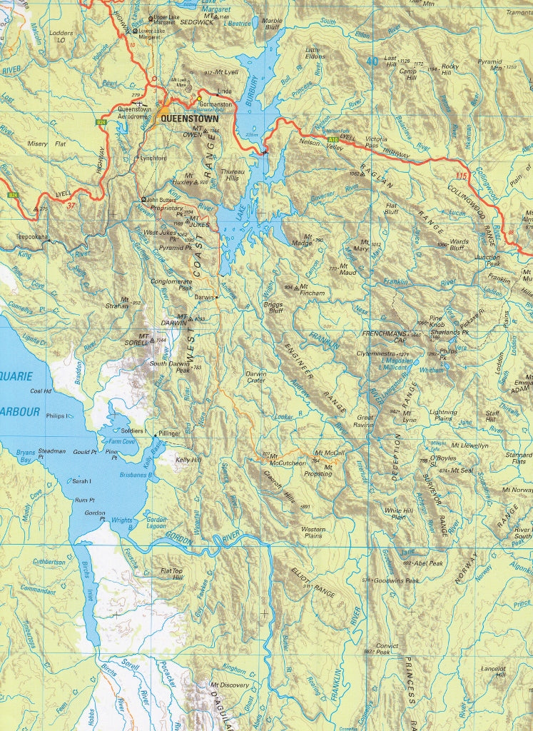
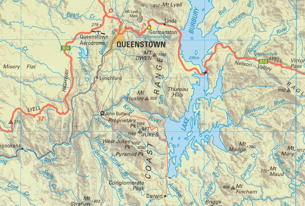
Tasmania South West Tasmap Map
$19.95
Afterpay is only available for orders between $50.00 and $1000.00 More info
An essential regional map for driving, cycling, planning and exploring south-western Tasmania beyond the most frequently travelled tourist routes.
The South West 1:250,000 Topographic Map by TASMAP provides a clear regional overview of south-western Tasmania, combining an extensive road network with terrain information, population centres and important geographic features. Produced in 2020, it is one of four maps that together cover all of Tasmania, with Macquarie Island and King Island represented as insets within the complete series.
Each map in the series covers approximately 37,000 square kilometres, making it an excellent reference for extended road journeys, regional planning, cycle touring and gaining a broad understanding of the landscape.
At 1:250,000 scale, 1 centimetre on the map represents 2.5 kilometres on the ground.
🗺️ Regional Map Coverage
The South West sheet is designed to show a large area in a single, practical map. Its regional scale makes it particularly useful when planning journeys between towns, identifying alternative roads and understanding how settlements, transport routes and major landforms relate to one another.
The map displays:
-
Major highways and important regional roads
-
Secondary and minor roads
-
Road surfaces and relative importance within Tasmania’s transport network
-
Distances between population centres and major road intersections
-
Towns, settlements and named localities
-
Contours at 100-metre vertical intervals
-
Hill shading for an intuitive representation of relief
-
Mountains, ranges, valleys and other major landforms
-
Rivers, lakes and drainage features
-
Reserves, forests and other significant geographic areas where mapped
-
Place names and general topographic information
With approximately 37,000 square kilometres represented on one sheet, the map allows users to see regional connections that may be difficult to appreciate on smaller-screen digital maps or more detailed topographic sheets.
🚗 Clear Road and Distance Information
Roads are symbolised according to their surface and importance in the state road network, helping users distinguish principal travel routes from secondary and less prominent roads.
Road distances are shown between population centres and major intersections, providing practical assistance when:
-
Planning daily driving stages
-
Estimating distances between towns and services
-
Comparing alternative regional routes
-
Preparing cycling itineraries
-
Coordinating field visits or work programs
-
Exploring areas away from common tourist corridors
This makes the South West map particularly valuable for travellers who want a dependable overview without relying entirely on mobile coverage, battery power or turn-by-turn navigation.
⛰️ Terrain and Topographic Detail
The shape of the land is represented through a combination of 100-metre contour intervals and hill shading.
Contours provide a measurable representation of elevation, while hill shading makes ranges, ridges, valleys and changes in relief easier to recognise at a glance. Together, these features help users understand how terrain may influence road routes, cycling difficulty, land use, access and travel time.
At 1:250,000, this map is designed for regional orientation rather than detailed off-track navigation. For remote bushwalking or precise local fieldwork, supplement it with an appropriate larger-scale topographic map, current access information and suitable navigation equipment.
🧭 Who Uses This Map?
The South West 1:250,000 Topographic Map is recommended for:
-
Drivers and road trippers exploring south-western Tasmania
-
Cycle tourers planning longer regional routes and daily stages
-
Regional planners and government personnel
-
Emergency services and operational coordinators requiring a broad-area reference
-
Tourism operators and visitor-information centres
-
Transport, infrastructure and utility professionals
-
Land managers, researchers and field teams
-
Students and educators studying Tasmanian geography
-
Residents and property owners seeking a regional overview
-
Visitors travelling beyond the common tourist routes
The map is equally useful as a journey-planning tool, a vehicle reference and a wall-based overview for offices, classrooms and operations rooms.
🧩 Part of a Four-Map Tasmania Series
The South West sheet is one of four regional maps produced in 2020 to provide complete coverage of Tasmania.
Across the series:
-
The whole of Tasmania is covered at a consistent 1:250,000 scale
-
Individual sheets cover approximately 37,000 square kilometres
-
Road and topographic information is presented in a consistent style
-
Macquarie Island and King Island are included as inset coverage
-
Adjacent sheets can be combined for journeys extending beyond a single region
This modular format allows users to purchase the sheet relevant to their destination or assemble the complete series for statewide planning and reference.
💧 Field-Ready Options for Rugged Use
Choose the format that best suits your intended use—from lightweight journey planning to regular all-weather field reference.
✅ Standard Paper
-
Printed on 100 gsm FSC® coated paper
-
Produces crisp, clear road labels, place names and topographic symbols
-
Lightweight and convenient for trip planning or protected vehicle use
-
An economical choice for general reference, offices and classrooms
✅ Waterproof and Tearproof Tyvek®
-
Made from genuine DuPont™ Tyvek®, an advanced synthetic material composed of pure polyethylene fibres
-
Waterproof, tear-resistant, foldable and extremely lightweight
-
Printed using HP pigment-based inks for a permanent waterproof finish
-
Suitable for vehicles, panniers, backpacks and exposed field conditions
-
Ideal for drivers, cyclists, field personnel and outdoor professionals
-
Provides exceptional durability without the weight and bulk of lamination
✅ Laminated
-
Fully encapsulated between two 80-micron gloss laminate sheets
-
Highly resistant to water, stains, smudges and tearing
-
Draw on the surface with whiteboard markers for journey or operational planning
-
Use Mark-It-Dots to identify destinations, work sites, hazards or stopping points without marking the map permanently
-
Wipeable and reusable
-
Ideal for offices, classrooms, visitor centres and operations rooms
📐 Map Details
-
Title: South West Topographic Map
-
Series: Tasmania 1:250,000 Topographic Map Series
-
Production year: 2020
-
Scale: 1:250,000
-
Ground distance: 1 cm represents 2.5 kilometres
-
Approximate area covered: 37,000 km²
-
Contour interval: 100 metres
-
Terrain depiction: Contours and hill shading
-
Road information: Road classification, surface and distances between key locations and intersections
-
Series coverage: Four maps covering Tasmania, including Macquarie Island and King Island as insets
-
Available formats: Paper, waterproof Tyvek® or laminated
🛒 Choose the Right Format
-
Paper: Best for trip planning, office reference and protected vehicle use
-
Tyvek®: Best for cycle touring, extended road trips and demanding field conditions
-
Laminated: Best for repeated route marking, regional planning, education and operational use
🎯 Summary
Whether you are planning a driving journey through south-western Tasmania, preparing a long-distance cycling route, coordinating regional fieldwork or simply seeking a clear overview of the area, the South West 1:250,000 Topographic Map provides the road, distance and terrain information needed to understand the region and travel with confidence.
Plan the wider journey. Understand the terrain. Explore south-western Tasmania with confidence.
Frequently Asked Questions
Where can I buy the Tasmania South West Tasmap Map?
The Tasmania South West Tasmap Map is available to buy online from Mapworld, Australia's largest map and geographic product retailer, with fast shipping Australia-wide.
Is the Tasmania South West Tasmap Map in stock at Mapworld?
Mapworld maintains extensive stock across its map range and aims for fast dispatch. Orders placed before 2pm AEST on business days are typically dispatched the same day, with standard and express Australia-wide delivery options available.
What is Mapworld's returns policy?
Mapworld accepts returns on undamaged items in original condition. Contact Mapworld within 90 days of purchase to arrange a return or exchange.
Does Mapworld ship the Tasmania South West Tasmap Map across Australia?
Yes, Mapworld ships Australia-wide. Standard shipping is a flat $7 rate, with free standard shipping on orders over $75. Express options are available at checkout. Most orders placed before 2pm AEST on weekdays are dispatched same day.
Related Items
© 2026 Mapworld. Website designed by Genie Media


X