- Australia ▾
- Topographic
▾
- Australia AUSTopo 250k (2024)
- Australia 50k Geoscience maps
- Australia 100k Geoscience maps
- Australia 250k Geoscience maps
- Australia 1.1m Geoscience maps
- New Zealand 50k maps
- New Zealand 250k maps
- New South Wales 25k maps
- New South Wales 50k maps
- New South Wales 100k maps
- Queensland 10k maps
- Queensland 25k maps
- Queensland 50k maps
- Queensland 100k maps
- Compasses
- Software
- GPS Systems
- Orienteering
- International ▾
- Wall Maps
▾
- World
- Australia & New Zealand
- Countries, Continents & Regions
- Historical
- Vintage National Geographic
- Australian Capital Territory
- New South Wales
- Northern Territory
- Queensland
- South Australia
- Tasmania
- Victoria
- Western Australia
- Celestial
- Children's
- Mining & Resources
- Wine Maps
- Healthcare
- Postcode Maps
- Electoral Maps
- Nautical ▾
- Flags
▾
- Australian Flag Sets & Banners
- Flag Bunting
- Handwavers
- Australian National Flags
- Aboriginal Flags
- Torres Strait Islander Flags
- International Flags
- Flagpoles & Accessories
- Australian Capital Territory Flags
- New South Wales Flags
- Northern Territory Flags
- Queensland Flags
- South Australia Flags
- Tasmania Flags
- Victoria Flags
- Western Australia Flags
- Gifts ▾
- Globes ▾
Dear valued customer. Please note that our checkout is not supported by old browsers. Please use a recent browser to access all checkout capabilities


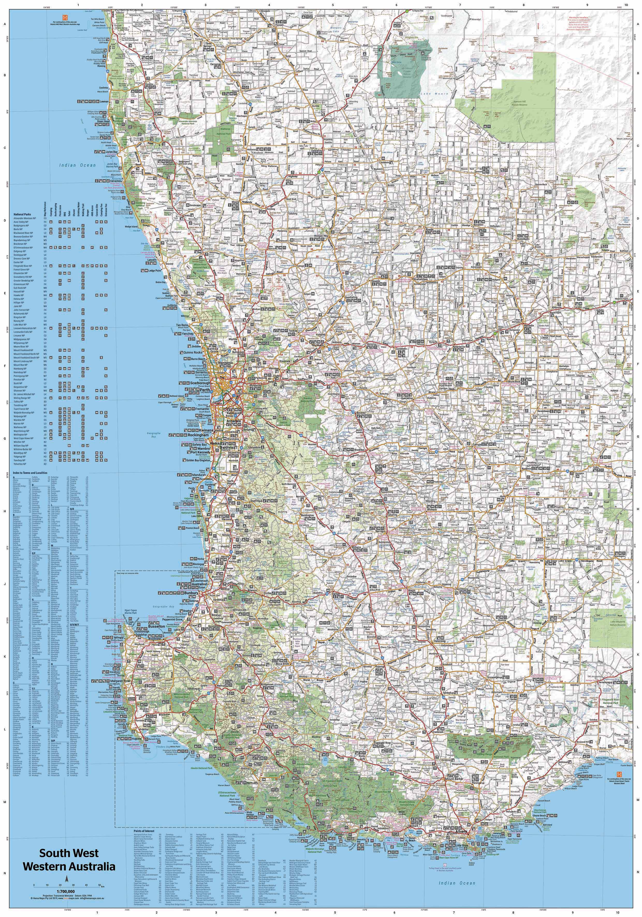
South West Western Australia Map – Hema Maps (1st Edition)
$14.95 $15.95
Afterpay is only available for orders between $50.00 and $1000.00 More info
Explore wine country, wild coastlines, ancient forests, and rugged trails — the ultimate travel companion for the south-west corner of the state.
The South West Western Australia Map by Hema Maps is an exceptionally detailed and beautifully presented touring map designed for anyone exploring this richly diverse region of Australia. Whether you're planning a scenic coastal road trip, a 4WD journey through national parks, or a gourmet trail through world-renowned wine regions, this map is your essential tool for discovery, direction, and adventure.
Covering a vast area from Jurien Bay in the north to Albany and the Stirling Range in the south, this map includes an extraordinary amount of detail on everything from main highways to unsealed bush tracks — making it ideal for both casual holidaymakers and serious explorers.
🗺️ Key Map Features
🚗 Comprehensive Road & Track Detail
-
Accurate depiction of all major highways, secondary roads, tourist routes, and 4WD tracks
-
Unsealed roads and remote tracks are marked to help drivers prepare for changing terrain
-
Road distances are clearly labelled between key points
🏕️ Camping & Accommodation Info
-
Locations of campgrounds, caravan parks, rest areas, and visitor centres
-
Notations for fuel stops and service stations — ideal for planning refuelling points in remote areas
🌲 National Parks & Natural Landmarks
-
Detailed mapping of parks including:
-
Leeuwin-Naturaliste National Park
-
D’Entrecasteaux National Park
-
Wellington National Park
-
Stirling Range National Park
-
-
Includes picnic areas, hiking trails, and scenic lookouts
🍷 Points of Interest & Touring Highlights
-
Marked locations of wineries, galleries, lighthouses, historic towns, and coastal attractions
-
Suggestions for drives and loops through iconic regions like:
-
Margaret River
-
Denmark & Walpole
-
Pemberton’s Karri forests
-
🗺️ Inset Maps for Popular Regions
-
High-detail insets at a larger scale (1:200,000) of:
-
The South West Corner
-
Wellington NP
-
Leeuwin-Naturaliste NP
-
D’Entrecasteaux NP
-
-
Perfect for zooming into tourist-heavy or off-road areas
📐 Map Specifications
-
Edition: 1st Edition
-
Published: November 2020
-
Main Scale: 1:700,000
-
Inset Scale (South West Corner): 1:200,000
-
Flat Size: 1000 mm (W) × 700 mm (H)
-
Folded Size: 140 mm × 250 mm × 3 mm
-
Weight: Approx. 70 g
-
Map Format: Paper or laminated
-
Publisher: Hema Maps
-
Made in: Australia
🖨️ Print & Lamination Quality
-
Printed on premium paper stock using fade-resistant pigment-based inks
-
Laminated versions are fully encapsulated between two sheets of 80-micron gloss laminate, making them:
-
Waterproof and tear-resistant
-
Wipeable, suitable for use with whiteboard markers
-
Perfect for repeated handling and long-term display
-
🛒 Purchase Options
-
Standard Folded Map (Paper) – From $15.95
-
Lightweight and compact – fits in a glove box, backpack, or map pouch
-
-
Flat Laminated Map – From $49.95
-
Suitable for pinning or framing in a caravan, office, or holiday home
-
-
Supermap Laminated Wall Version – 1000 mm x 1430 mm – From $149.95
-
Great for travel agencies, planning rooms, classrooms, or serious WA adventurers
-
🎯 Ideal For
-
Road trippers and grey nomads mapping scenic drives and overnight stops
-
4WD adventurers navigating the region’s back roads and national parks
-
Wine and food tourists planning trails through Margaret River and beyond
-
Teachers and students exploring regional geography and landforms
-
Tour operators and regional planners requiring reliable cartographic data
-
Anyone heading to the south-west who wants to explore more than just the main highways
✅ Why Choose the South West WA Hema Map?
-
Combines touring detail and off-road access in one comprehensive product
-
Created by Hema Maps, Australia’s most trusted cartography publisher for outback and regional travel
-
Features expertly curated information backed by fieldwork and GPS mapping
-
Made and printed in Australia, with high standards in material and map design
From Karri forests to surf beaches, vineyard valleys to granite peaks — the South West of Western Australia is a region like no other.
Plan your perfect journey with confidence, insight, and detail — with the Hema South West WA Map at your side.


