A Federation-Era Cartographic Masterpiece from the Lady Northcote Atlas of Australia
Originally Published: 1908
Printed & Finished in Australia
🇦🇺 A Glorious Glimpse into Federation-Era South Australia
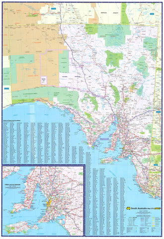
Experience a remarkable slice of Australia's cartographic heritage with this faithfully restored reproduction from the Lady Northcote Atlas of Australia, first published by the esteemed H.E.C. Robinson in 1908.
This striking wall map transports you back to the early 20th century—an era of rail expansion, flourishing pastoralism, and post-Federation optimism. It’s far more than a vintage decorative piece; it’s a detailed record of South Australia’s emerging infrastructure, carefully delineated land tenure, and beautifully drawn typography—all reproduced with archival clarity.
Whether you’re a map collector, a history lover, or simply someone with a deep appreciation for timeless design, this map makes a statement.
🖼️ Finishes to Suit Every Setting
From gallery-worthy prints to hands-on educational tools, this map is available in a range of high-quality finishes:
| Finish | Description |
|---|---|
| Heavyweight Paper (160 gsm) | Ideal for custom framing behind glass. Smooth matte-coated stock with rich ink absorption. |
| Encapsulated Laminate (Gloss 80 Micron) | Durable, wipeable and perfect for busy spaces. Use whiteboard markers or map dots without damage. |
| Canvas (395 gsm HP Professional Matte) | Printed with fade-resistant pigment inks on archival-grade canvas. Offers fine texture and elegant colour depth—suitable for loose hanging or stretching. |
| Laminated & Canvas with Timber Hang Rails | A complete display solution. Supplied ready to hang, with handcrafted timber battens top and bottom (natural lacquer finish) and hanging cord. No frame required. |
⏳ Please allow up to 10 working days for delivery of hang-railed maps, as these are hand-finished by our professional framer.
🔍 Historical Features at a Glance
-
Federation-era topographic and political layout of South Australia
-
Clearly marked pastoral lease boundaries and tenures
-
Major rail lines, roads, rivers, towns, and ports as recorded in 1908
-
Ornate typography and relief shading reflecting Edwardian design conventions
-
Reproduced title panel from the original atlas for authenticity
-
Carefully restored and enlarged for legibility and display
🏡 Ideal For:
-
Vintage-style interior design or office decor
-
Council chambers, government offices, and libraries
-
Classrooms, heritage exhibitions, or academic institutions
-
Thoughtful gifts for historians, genealogists, or heritage-focused organisations
-
Anyone with a connection to South Australia—past or present
📐 Technical Specifications
| Specification | Detail |
|---|---|
| Source | Lady Northcote Atlas of Australia, H.E.C. Robinson (1908) |
| Reproduction Type | High-resolution enlargement |
| Sizes | 660 x 900 mm (Standard), 1020 x 1390 mm (Large) |
| Paper | 160 gsm matte-coated stock |
| Lamination | Dual-sided 80-micron gloss encapsulation |
| Canvas | 395 gsm HP Matte with pigment inks |
| Hang Rails | Lacquered timber (natural finish) with cotton cord |
| Production | Printed and finished in Australia |
🚚 Shipping & Delivery
-
📦 Maps shipped rolled or flat, depending on finish
-
🛠️ Hang-railed canvas maps require up to 10 business days for professional framing
-
🚚 Courier delivery required for large or hang-railed items — no PO Boxes
-
📮 All orders are securely packaged to ensure pristine condition upon arrival
🎁 A Gift with Enduring Significance
A map that celebrates place, history, and beauty. Ideal for commemorating milestone birthdays, retirements, office openings, or simply honouring a personal connection to South Australia’s rich past.
🛒 Select your size and finish above to order this rare and beautiful Federation-era map of South Australia.
Timeless, tactile, and proudly Australian—this is more than a map. It’s a legacy.