- Australia ▾
- Topographic
▾
- Australia AUSTopo 250k (2025)
- Australia 50k Geoscience maps
- Australia 100k Geoscience maps
- Australia 250k Geoscience maps
- Australia 1:1m Geoscience maps
- New Zealand 50k maps
- New Zealand 250k maps
- New South Wales 25k maps
- New South Wales 50k maps
- New South Wales 100k maps
- Queensland 10k maps
- Queensland 25k maps
- Queensland 50k maps
- Queensland 100k maps
- Western Australia 25k maps
- Western Australia 50k maps
- Western Australia 100k maps
- Compasses
- Software
- GPS Systems
- International ▾
- Wall Maps
▾
- World
- Australia & New Zealand
- Countries, Continents & Regions
- Historical
- Vintage National Geographic
- Australian Capital Territory
- New South Wales
- Northern Territory
- Queensland
- South Australia
- Tasmania
- Victoria
- Western Australia
- Celestial
- Children's
- Mining & Resources
- Wine Maps
- Healthcare
- Postcode Maps
- Electoral Maps
- Nautical ▾
- Flags
▾
- Australian Flag Sets & Banners
- Flag Bunting
- Handwavers
- Australian National Flags
- Aboriginal Flags
- Torres Strait Islander Flags
- International Flags
- Flagpoles & Accessories
- Australian Capital Territory Flags
- New South Wales Flags
- Northern Territory Flags
- Queensland Flags
- South Australia Flags
- Tasmania Flags
- Victoria Flags
- Western Australia Flags
- Gifts ▾
- Globes ▾
Dear valued customer. Please note that our checkout is not supported by old browsers. Please use a recent browser to access all checkout capabilities


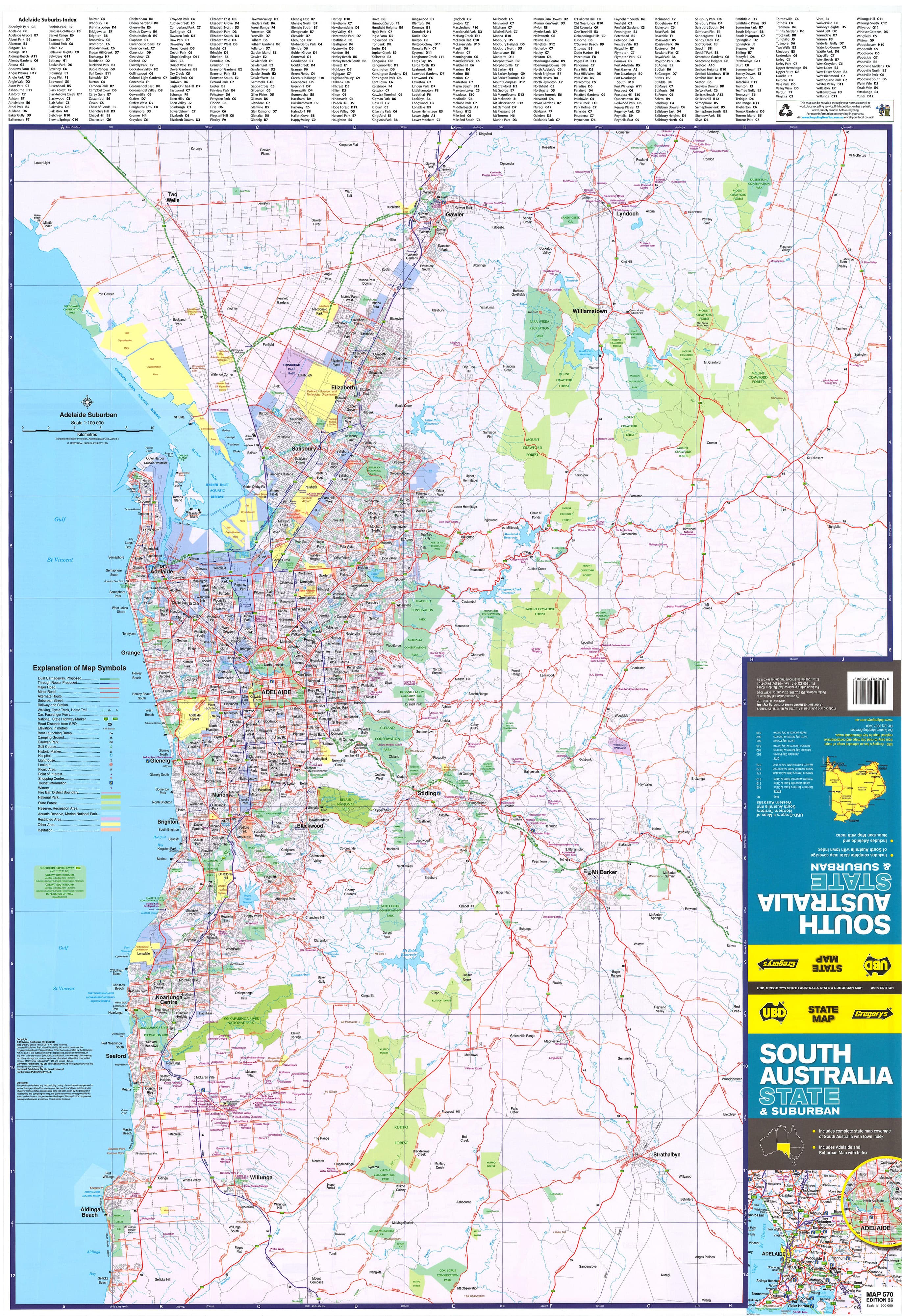
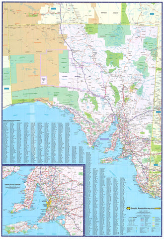
South Australia UBD 570 Map 690 x 1000mm Laminated Wall Map
$49.95
Afterpay is only available for orders between $50.00 and $1000.00 More info
Your Essential Guide to South Australia – From the Outback to Adelaide's Suburbs
Covering the entirety of South Australia on one side and metropolitan Adelaide on the other, this double-sided laminated wall map is a comprehensive, highly detailed navigational and planning resource. Produced by the cartographic experts at UBD Gregory’s, this map is an indispensable tool whether you’re planning regional logistics, teaching geography, exploring the outback, or navigating the city streets of Adelaide.
🌏 Side A: Statewide South Australia Overview
Scale: 1:1,900,000
This side provides a full overview of South Australia’s diverse geography, including its vast desert landscapes, wine regions, and coastal towns. It is ideal for use in:
-
🚗 Trip planning and route optimisation
-
🏞️ Tourism operators and travel consultants
-
🗂️ Regional logistics and distribution
-
📚 Secondary or tertiary education
Key Features Include:
-
🛣️ Clearly marked national and regional highways
-
🏘️ All major towns and regional centres indexed for fast lookup
-
🌄 National parks and nature reserves clearly shown
-
🚦 Includes dual carriageways, distances between key towns, and tourist routes
-
🏕️ Ideal for 4WD enthusiasts, caravanners, and Grey Nomads
🏙️ Side B: Greater Metropolitan Adelaide Map
Scale: 1:100,000
From Gawler in the north to Aldinga Beach in the south, this side delivers a detailed suburban street view of Adelaide, including:
-
🧭 All suburb names labeled and indexed
-
📮 Postcodes shown for each suburb—perfect for delivery zones
-
🛣️ Major arterial roads and key intersections clearly marked
-
🌳 Includes parks, reserves, national parks, and industrial areas
-
🍇 Features a detailed inset map of the Barossa Valley, South Australia’s world-renowned wine region
This map is especially useful for:
-
🚚 Service and delivery providers
-
🏘️ Property developers and real estate agents
-
🏫 Schools and tertiary institutions
-
📍 New residents learning the layout of the city
💎 Premium Finishes and Laminated Options
| Option | Description |
|---|---|
| Flat Laminated – $99 | Professionally finished, perfect for display in offices or classrooms. No fold lines, sleek appearance, ideal for framing. |
| Folded Laminated – $49.95 | Economical version laminated from a pre-folded map. May show light creases but fully functional, rugged and versatile for everyday use or fieldwork. |
Both versions use high-gloss 80-micron laminate, which:
-
✅ Protects against tears, stains, and spills
-
✅ Allows you to draw temporary notes with whiteboard markers
-
✅ Supports the use of repositionable Mark-It Dots (great for marking delivery zones, travel stops, or office locations)
📐 Specifications at a Glance
| Feature | Details |
|---|---|
| Published | 2023 |
| Scale | 1:1,900,000 (State) / 1:100,000 (Metro Adelaide) |
| Size | 690 mm (W) x 1000 mm (H) |
| Format | Double-sided laminated (flat or folded) |
| Publisher | UBD Gregory’s |
🎯 Who Is This Map For?
| Use Case | Why It's Ideal |
|---|---|
| Travellers & Tourists | Plan outback adventures or road trips from the Eyre Peninsula to the Murraylands. |
| Educators & Schools | A great tool for teaching South Australian geography. |
| Government & Councils | Regional planning, infrastructure and community development. |
| Real Estate & Property | For clearly showing suburban layouts, postcodes, and road access. |
| Delivery & Logistics | Ideal reference for couriers, drivers, and distribution managers. |
🚚 Shipping & Handling
-
Flat laminated maps are carefully rolled and packed in protective mailing tubes
-
Standard processing: Ships in 1–2 business days
-
Hang Rail Orders: Please allow up to 10 working days
Add This Map to Your Wall – and Make Every Journey Count
Combining accuracy, durability, and ease of use, the South Australia State & Suburban Map by UBD Gregory’s is the go-to reference for anyone who needs a clear, attractive, and information-rich map of South Australia. Whether you're navigating the vineyards of Clare Valley or planning your next service run in Adelaide, this map has you covered.
Frequently Asked Questions
What are the dimensions of the South Australia UBD 570 Map 690 x 1000mm Laminated Wall Map?
Mapworld wall maps range from standard 700×1000mm to large-format 1000×1430mm Supermaps. The exact dimensions for this map are shown in the product title. Where multiple sizes are available, select your preferred size when adding to cart.
Is this wall map available laminated?
Many Mapworld wall maps are available in paper, laminated, or framed finishes. Check the product options when adding to cart. Laminated maps are wipe-clean and more durable.
Is this the latest edition?
Mapworld stocks the most current editions available from all publishers. Edition year is shown in the product title where applicable. Mapworld updates its catalogue as new editions are released.
Can I write on or pin this wall map?
Laminated wall maps can be written on with whiteboard markers and wiped clean. Paper maps can be pinned on a corkboard. Choose a laminated option for a writeable surface.
Does Mapworld ship the South Australia UBD 570 Map 690 x 1000mm Laminated Wall Map across Australia?
Yes, Mapworld ships Australia-wide. Standard shipping is a flat $7 rate, with free standard shipping on orders over $75. Express options are available at checkout. Most orders placed before 2pm AEST on weekdays are dispatched same day.
Related Items


© 2026 Mapworld. Website designed by Genie Media
X