- Australia ▾
- Topographic
▾
- Australia AUSTopo 250k (2025)
- Australia 50k Geoscience maps
- Australia 100k Geoscience maps
- Australia 250k Geoscience maps
- Australia 1:1m Geoscience maps
- New Zealand 50k maps
- New Zealand 250k maps
- New South Wales 25k maps
- New South Wales 50k maps
- New South Wales 100k maps
- Queensland 10k maps
- Queensland 25k maps
- Queensland 50k maps
- Queensland 100k maps
- Compasses
- Software
- GPS Systems
- Orienteering
- International ▾
- Wall Maps
▾
- World
- Australia & New Zealand
- Countries, Continents & Regions
- Historical
- Vintage National Geographic
- Australian Capital Territory
- New South Wales
- Northern Territory
- Queensland
- South Australia
- Tasmania
- Victoria
- Western Australia
- Celestial
- Children's
- Mining & Resources
- Wine Maps
- Healthcare
- Postcode Maps
- Electoral Maps
- Nautical ▾
- Flags
▾
- Australian Flag Sets & Banners
- Flag Bunting
- Handwavers
- Australian National Flags
- Aboriginal Flags
- Torres Strait Islander Flags
- International Flags
- Flagpoles & Accessories
- Australian Capital Territory Flags
- New South Wales Flags
- Northern Territory Flags
- Queensland Flags
- South Australia Flags
- Tasmania Flags
- Victoria Flags
- Western Australia Flags
- Gifts ▾
- Globes ▾
Dear valued customer. Please note that our checkout is not supported by old browsers. Please use a recent browser to access all checkout capabilities


Israel & Palestine ITMB Map
$24.95
Afterpay is only available for orders between $50.00 and $1000.00 More info
Durable | Waterproof | Double-Sided | Folded Edition
Scale: 1:225,000 | Size: 690 mm x 1000 mm
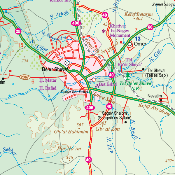
Uncover the history, diversity, and landscapes of the Middle East with this exceptionally detailed travel map of Israel and Palestine by ITMB (International Travel Maps). Designed for travellers, researchers, and map lovers alike, this folded, double-sided map is printed on tear-resistant, waterproof plastic paper, making it an indispensable companion for everything from field exploration to classroom learning.
Map Coverage & Details:
🧭 Side A: Northern Israel & the Palestinian Territories
-
Major Cities: Jerusalem, Tel Aviv, Haifa, Tiberias, Acre, Nazareth, Nablus, Jenin
-
Regions: Galilee, West Bank, Golan Heights, Jezreel Valley, Jordan River
-
Key Sites: Sea of Galilee, Church of the Annunciation, Mount Carmel, Dome of the Rock (Old City), Dead Sea access
-
Border Coverage: Includes boundaries with Lebanon, Syria, and Jordan
🧭 Side B: Southern Israel & Gaza
-
Cities & Towns: Eilat, Beersheba, Ashdod, Ashkelon, Hebron, Gaza City
-
Geographical Features: Negev Desert, Ramon Crater, Gulf of Aqaba, Red Sea
-
Points of Interest: Masada, Ein Gedi Nature Reserve, Timna Park, Dead Sea Resorts
-
Border Coverage: Extends into southern West Bank and border with Egypt's Sinai Peninsula
Highlighted Features:
-
✅ Updated Cartography with political boundaries, roads, and cultural landmarks
-
✅ Road Classifications: Includes motorways, regional roads, and remote tracks
-
✅ Religious & Cultural Landmarks: Mosques, synagogues, churches, archaeological sites
-
✅ Natural Features: Mountains, wadis, desert regions, national parks, and nature reserves
-
✅ Airports, Ports, and Border Crossings marked for ease of transit
-
✅ Public Transportation Links including railways and ferry routes
-
✅ Comprehensive Index for rapid navigation and trip planning
-
✅ Tourist Icons for UNESCO World Heritage sites, ruins, viewpoints, and more
Built to Last: Waterproof & Tear-Resistant
Printed on high-grade synthetic plastic paper, this map is:
-
✅ Waterproof and suitable for use in rain, desert, or humid conditions
-
✅ Tear-resistant and wipeable for long-term durability
-
✅ Foldable down to a convenient travel size—fits in backpacks, day bags, or glove compartments
🖊️ Lamination Option Available
Want to enhance your map for classroom, office or planning use?
Opt for laminated encapsulation to unlock these extra benefits:
-
🧽 Write-on/wipe-off surface with dry-erase markers
-
📍 Apply removable map dots or sticky notes without damage
-
🛡️ Long-term protection against spills, smudges, and folding wear
🛠️ To laminate this map, we flatten the folded sheet and seal it between two sheets of premium 80-micron gloss laminate. Please note: fold lines will still be faintly visible under the lamination.
📐 Technical Specifications:
| Feature | Detail |
|---|---|
| Title | Israel & Palestine Travel Map |
| Publisher | ITMB (International Travel Maps) |
| Edition | Latest Edition |
| Scale | 1:225,000 |
| Size (Flat) | 690 mm x 1000 mm |
| Format | Double-sided folded map |
| Material | Synthetic waterproof & tearproof paper |
| Optional Lamination | ✅ Yes – add-on available |
| Folded Size | Pocket-sized, easy to carry |
🌍 Who Is This Map For?
-
Travellers & Tourists exploring Israel, Gaza, or the West Bank
-
Pilgrims & Religious Tourists visiting Christian, Jewish, or Islamic landmarks
-
Researchers & Educators needing clear cartographic detail
-
Students of History or Politics examining borders and settlement regions
-
Planners, NGOs & Development Agencies working in the region
Whether you’re tracing ancient trade routes, navigating between sacred sites, or gaining geographic context for regional events, the Israel & Palestine ITMB Map is an invaluable tool for anyone seeking to better understand and explore this profoundly complex and beautiful part of the world.
Frequently Asked Questions
Where can I buy the Israel & Palestine ITMB Map?
The Israel & Palestine ITMB Map is available to buy online from Mapworld, Australia's largest map and geographic product retailer, with fast shipping Australia-wide.
Is the Israel & Palestine ITMB Map in stock at Mapworld?
Mapworld maintains extensive stock across its map range and aims for fast dispatch. Orders placed before 2pm AEST on business days are typically dispatched the same day, with standard and express Australia-wide delivery options available.
What is Mapworld's returns policy?
Mapworld accepts returns on undamaged items in original condition. Contact Mapworld within 90 days of purchase to arrange a return or exchange.
Does Mapworld ship the Israel & Palestine ITMB Map across Australia?
Yes, Mapworld ships Australia-wide. Standard shipping is a flat $7 rate, with free standard shipping on orders over $75. Express options are available at checkout. Most orders placed before 2pm AEST on weekdays are dispatched same day.
Related Items


© 2026 Mapworld. Website designed by Genie Media
X