- Australia ▾
- Topographic
▾
- Australia AUSTopo 250k (2024)
- Australia 50k Geoscience maps
- Australia 100k Geoscience maps
- Australia 250k Geoscience maps
- Australia 1.1m Geoscience maps
- New Zealand 50k maps
- New Zealand 250k maps
- New South Wales 25k maps
- New South Wales 50k maps
- New South Wales 100k maps
- Queensland 10k maps
- Queensland 25k maps
- Queensland 50k maps
- Queensland 100k maps
- Compasses
- Software
- GPS Systems
- Orienteering
- International ▾
- Wall Maps
▾
- World
- Australia & New Zealand
- Countries, Continents & Regions
- Historical
- Vintage National Geographic
- Australian Capital Territory
- New South Wales
- Northern Territory
- Queensland
- South Australia
- Tasmania
- Victoria
- Western Australia
- Celestial
- Children's
- Mining & Resources
- Wine Maps
- Healthcare
- Postcode Maps
- Electoral Maps
- Nautical ▾
- Flags
▾
- Australian Flag Sets & Banners
- Flag Bunting
- Handwavers
- Australian National Flags
- Aboriginal Flags
- Torres Strait Islander Flags
- International Flags
- Flagpoles & Accessories
- Australian Capital Territory Flags
- New South Wales Flags
- Northern Territory Flags
- Queensland Flags
- South Australia Flags
- Tasmania Flags
- Victoria Flags
- Western Australia Flags
- Gifts ▾
- Globes ▾
Dear valued customer. Please note that our checkout is not supported by old browsers. Please use a recent browser to access all checkout capabilities


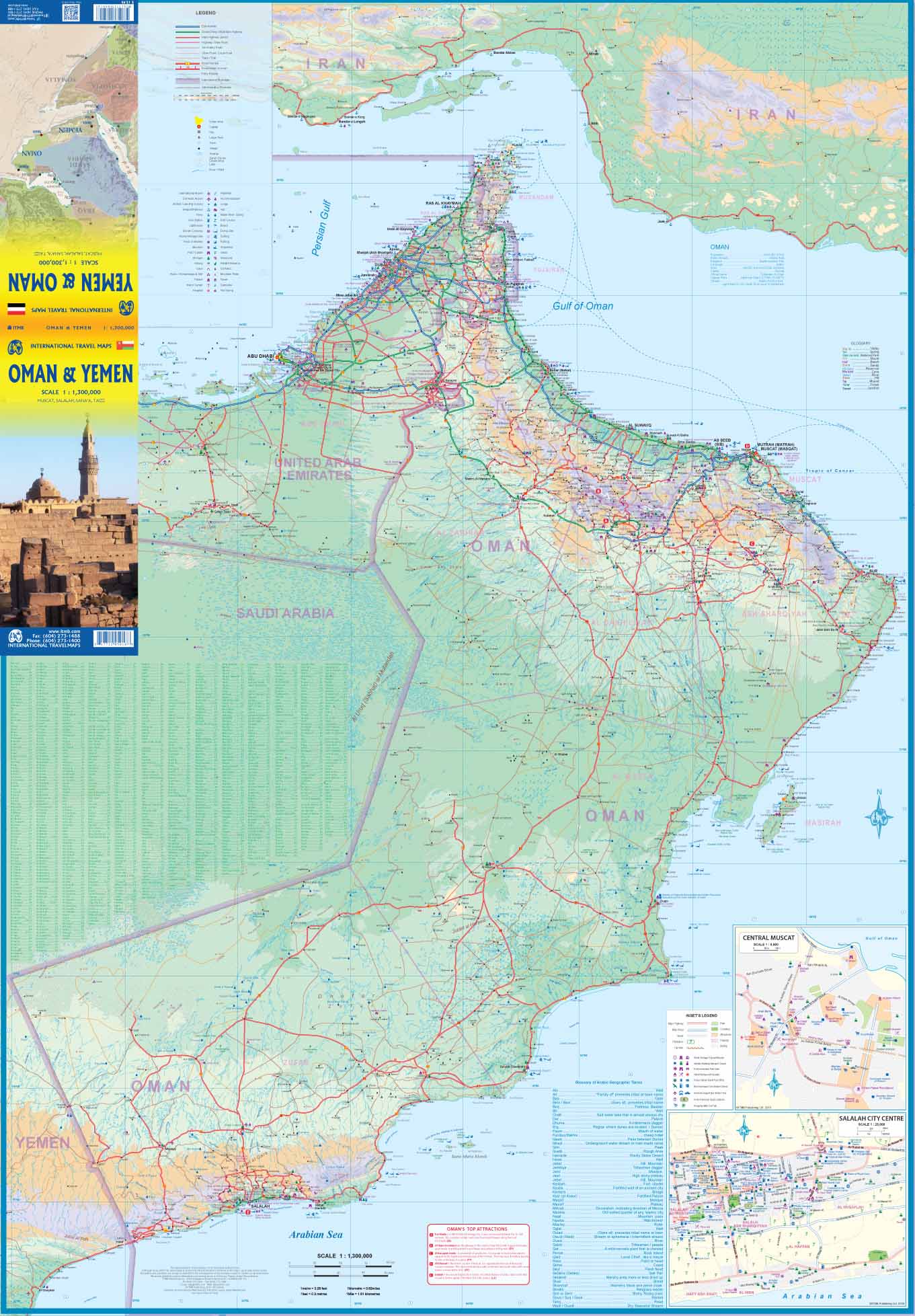
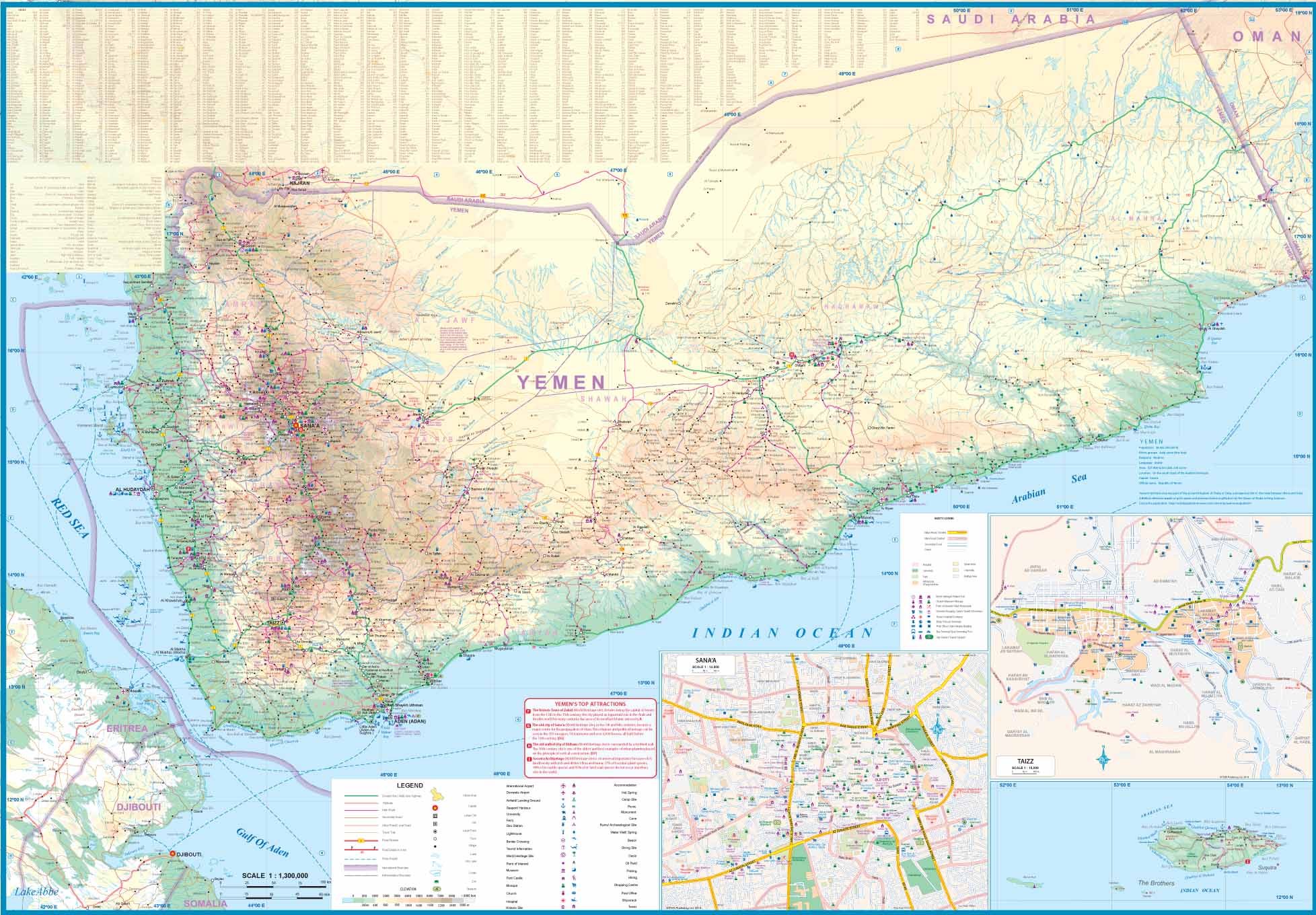
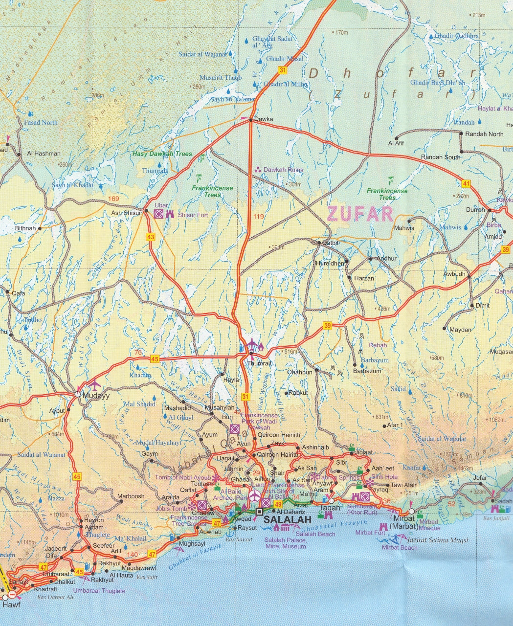
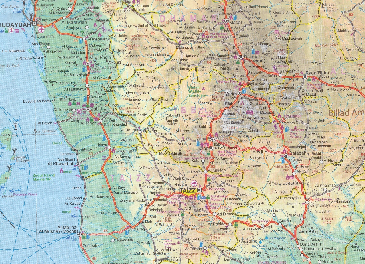
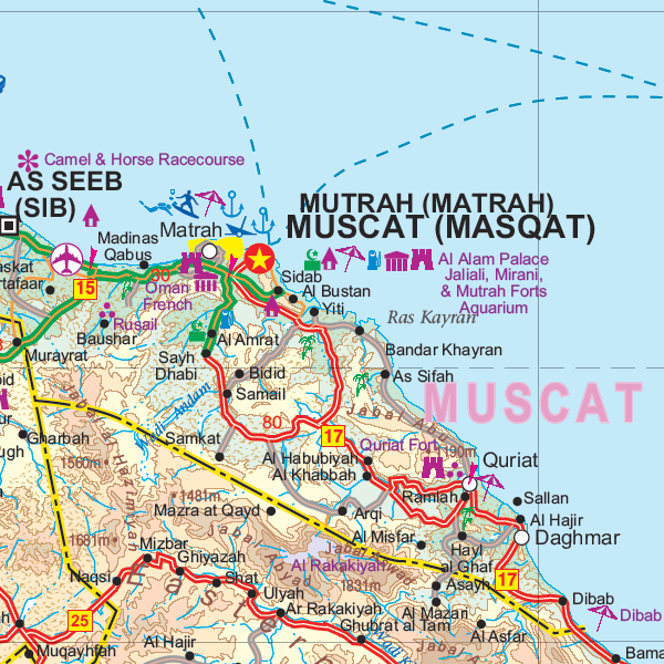
Oman & Yemen ITMB Map
$24.95
Afterpay is only available for orders between $50.00 and $1000.00 More info
Detailed Double-Country Map for Two of Arabia’s Most Captivating Landscapes
Scale: 1:1,400,000
Size: 690 mm x 990 mm
Optional Laminated Edition Available
Explore two of the Arabian Peninsula’s most culturally rich and geographically dramatic nations with the Oman & Yemen Travel Map from ITMB (International Travel Maps). This detailed map highlights the rugged terrain, road networks, and key locations of both countries, making it an invaluable reference for travellers, researchers, and regional planners.
🇴🇲 About Oman
Known for its stark deserts, soaring mountains, and endless coastline, Oman offers a landscape that feels both ancient and untouched. This map beautifully captures the topography of Oman, from the Al Hajar mountain range to the Wahiba Sands and the lush Dhofar region in the south.
-
🗺️ Detailed road network, including highways and desert routes
-
🧭 Accurate physical features with shaded relief showing mountains, wadis, and valleys
-
🕌 Key cities like Muscat, Nizwa, Salalah, and more clearly marked
-
🏕️ Tourist landmarks, border crossings, and remote access points identified
🇾🇪 About Yemen
Yemen remains one of the most enigmatic and least-explored countries in the world. Despite its current political challenges, its geography is stunning—from the highland plateaus and terraced villages to coastal plains and isolated islands. This map does an outstanding job of revealing the physical beauty of the country.
-
🏞️ Exotic and mountainous terrain rendered with exceptional clarity
-
🌆 Key urban centres like Sana’a, Aden, and Mukalla noted
-
📍 Roadways, ports, and airfields clearly marked
-
🏝️ Coastal islands such as Socotra also included
While tourism may be limited at present, this map serves as a valuable resource for researchers, humanitarian professionals, or cultural historians with interests in the region.
🖨️ Optional Laminated Edition
For those who want a map that can withstand field use or frequent handling, we offer a laminated version, finished with:
-
✅ 80-micron gloss laminate, encapsulating both sides for durability
-
✅ Tear-resistant and waterproof – ideal for travel, fieldwork, or educational use
-
✅ Compatible with whiteboard markers for temporary notations
-
✅ Suitable for map dots to mark locations of interest or travel history
Note: Laminated versions are created from flattened folded maps. Some light fold lines may remain visible under the laminate.
📐 Specifications
| Feature | Detail |
|---|---|
| Map Title | Oman & Yemen Travel Map |
| Publisher | ITMB (International Travel Maps) |
| Scale | 1:1,400,000 |
| Size (Flat) | 690 mm x 990 mm |
| Format | Folded map (optional laminated version) |
| Finish (Laminated) | 80-micron gloss laminate (optional) |
| Region Covered | Entirety of Oman and Yemen, incl. islands |
| Language | English |
| Printed In | Canada |
🧳 Ideal For:
-
🧭 Adventurous travellers and overlanders planning Gulf-region routes
-
🌍 Academics and regional analysts studying Middle Eastern geography
-
🚨 NGOs, journalists, or aid workers requiring clear country references
-
🏡 Map enthusiasts and collectors seeking lesser-known world regions
-
🎓 Educators and libraries teaching global geography and current affairs
🗨️ Final Word
The Oman & Yemen Map by ITMB offers a rare window into two of the most geologically and culturally distinct countries in the Arabian Peninsula. Whether you're studying the sprawling deserts of Oman or mapping the ancient mountain settlements of Yemen, this map is detailed, accurate, and beautifully rendered.
A practical tool. A collector’s piece. A striking conversation starter.


